- Maryland Route 392
-
Maryland Route 392
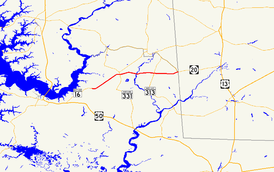
Maryland Route 392 highlighted in redRoute information Maintained by MDSHA Length: 13.54 mi[1] (21.79 km) Major junctions West end:  MD 16 in East New Market
 MD 14 in East New Market
 MD 331 in Hurlock
 MD 313 in Finchville
 MD 577 in Reliance
East end:  DE 20 in Reliance
Location Counties: Dorchester Highway system Maryland highway system
Interstate • US • State • Minor • Former • Turnpikes←  MD 390
MD 393  →
→Maryland Route 392 (MD 392) is a state highway in the U.S. state of Maryland. The state highway runs 13.54 miles (21.79 km) from MD 16 in East New Market east to the Delaware state line in Reliance, where the highway continues east as Delaware Route 20 (DE 20). MD 392 connects East New Market with Hurlock as well as Seaford, Delaware via DE 20. The state highway was constructed from Finchville to Reliance in the early 1930s. MD 392 was extended west to Hurlock in 1951 and to East New Market in 1957.
Contents
Route description
MD 392 begins at an intersection with MD 16 (Mount Holly Road) just outside the town of East New Market. The state highway heads east as the East New Market Bypass.[1] After passing Linkwood Road, MD 392 curves to the northeast and parallels the Seaford Line of the Maryland and Delaware Railroad as the highway passes through the outer edge of East New Market.[1][2] The state highway leaves the town limits after intersecting MD 14 (Railroad Avenue).[1] MD 392 passes through farmland and the hamlet of Hubbard on its way to Hurlock.[2] Just southwest of the town, Poplar Street (unsigned MD 392A) exits to head toward the center of Hurlock while MD 392 curves to the east, crossing the railroad track.[1][2] The state highway becomes Delaware Avenue while passing through the southern part of Hurlock.[1] MD 392 passes Hurlock Park and Hurlock Elementary School before intersecting MD 331 (Main Street).[2]
MD 392 crosses Wrights Branch at the east town limit of Hurlock and the highway's name changes to Harrison Ferry Road.[1] After passing through a forested area, the state highway crosses Palmer Mill Road in the hamlet of Harrison Ferry before traversing Marshyhope Creek on the Harrison Ferry Bridge. MD 392 passes through the Chesapeake Forest Lands before the farmland returns before the intersection with MD 313 (Eldorado Road) in Finchville. The state highway continues east along Finchville Reliance Road to the village of Reliance just west of the Delaware state line.[2] MD 392 intersects MD 577 (Reliance Road) 0.03 mi (0.048 km) west of the state line and meets Galestown Reliance Road on the state line itself.[1] The roadway continues east as DE 20 (Stein Highway) toward Seaford.[2]
History
MD 392 was constructed as a modern highway beginning in 1929 from Finchville.[3][4] The highway was completed to the Delaware state line by 1933.[5] In 1938, the existing Harrison Ferry Bridge was repaired and the county highway between there and Finchville was widened.[6] The highway between MD 14 in East New Market and Poplar Street in Hurlock was constructed on a new alignment as a county highway in 1939.[7] MD 392 was extended west from Finchville to MD 331 in Hurlock in 1951 following the relocation and reconstruction of the highway between Harrison Ferry and Hurlock.[8][9] New highway was constructed between MD 331 and Poplar Street south of Hurlock and between MD 14 and MD 16 south of East New Market in 1956 and 1957, respectively.[10][11] These bypasses and the reconstruction of the East New Market–Hurlock road were part of the extension of MD 392 to East New Market in 1957.[12][11] The present Harrison Ferry Bridge was constructed in 1999.[13]
Junction list
The entire route is in Dorchester County.
Location Mile
[1]Destinations Notes East New Market 0.00 MD 16 (Mount Holly Road) – Cambridge, PrestonWestern terminus 1.08 MD 14 (Railroad Avenue) – East New Market, RhodesdaleHurlock 4.36 Poplar Street north Unsigned MD 392A 4.98 MD 331 (Main Street) – Preston, ViennaFinchville 9.99 MD 313 (Eldorado Road) – Federalsburg, EldoradoReliance 13.51 MD 577 north (Reliance Road) – Federalsburg13.54 Galestown Reliance Road south – Galestown Eastern terminus; Delaware state line; Galestown Reliance Road is former MD 531 DE 20 east (Stein Highway) – Seaford, DE1.000 mi = 1.609 km; 1.000 km = 0.621 mi Auxiliary routes
MD 392A is the unsigned designation for a 0.08-mile (0.13 km) segment of Poplar Street adjacent to its southern terminus at MD 392 in Hurlock.[1][14]
References
- ^ a b c d e f g h i j "Highway Location Reference: Dorchester County" (PDF). Maryland State Highway Administration. 2009. http://www.marylandroads.com/Location/2009_DORCHESTER.pdf. Retrieved 2010-10-20.
- ^ a b c d e f Google, Inc. Google Maps – Maryland Route 392 (Map). Cartography by Google, Inc. http://maps.google.com/maps?f=d&source=s_d&saddr=County+Route+326%2FMD-392+E%2FE+New+Market+Bypass&daddr=Finchville+Reliance+Rd%2FMD-392+E&hl=en&geocode=FdrbTAIdclV5-w%3BFWCHTQId2st8-w&mra=ls&sll=38.622101,-75.856647&sspn=0.030645,0.077162&ie=UTF8&t=h&z=12. Retrieved 2010-05-18.
- ^ Report of the State Roads Commission of Maryland. 1927-1930. Baltimore: Maryland State Roads Commission. 1930-10-01. pp. 208–209. http://www.archive.org/details/reportofstateroa1927mary. Retrieved 2010-05-18.
- ^ Maryland Geological Survey. Map of Maryland Showing State Road System: State Aid Roads and Improved County Road Connections (Map) (1930 ed.).
- ^ Maryland Geological Survey. Map of Maryland Showing State Road System: State Aid Roads and Improved County Road Connections (Map) (1933 ed.).
- ^ Report of the State Roads Commission of Maryland. 1937-1938. Baltimore: Maryland State Roads Commission. 1939-03-04. p. 98. http://www.archive.org/details/reportofstateroa1937mary. Retrieved 2010-05-18.
- ^ Maryland State Roads Commission. General Highway Map: State of Maryland (Map) (1939 ed.).
- ^ Report of the State Roads Commission of Maryland. 1951-1952. Baltimore: Maryland State Roads Commission. 1952-12-15. pp. 114–115. http://www.archive.org/details/reportofstateroa1951mary. Retrieved 2010-05-18.
- ^ Maryland State Roads Commission. Maryland: Official Highway Map (Map) (1952 ed.).
- ^ Maryland State Roads Commission. Maryland: Official Highway Map (Map) (1956 ed.).
- ^ a b Maryland State Roads Commission. Maryland: Official Highway Map (Map) (1957 ed.).
- ^ Report of the State Roads Commission of Maryland. 1955-1956. Baltimore: Maryland State Roads Commission. 1956-11-02. p. 127. http://www.archive.org/details/reportofstateroa1955mary. Retrieved 2010-05-18.
- ^ "NBI Structure Number: 100000090015010". National Bridge Inventory. http://nationalbridges.com/nbi_record.php?StateCode=24&struct=100000090015010. Retrieved 2010-10-20.
- ^ Google, Inc. Google Maps – Maryland Route 392A (Map). Cartography by Google, Inc. http://maps.google.com/maps?f=d&source=s_d&saddr=Poplar+St&daddr=Poplar+St&hl=en&geocode=FZ1sTQIdFkp6-w%3BFfBvTQIde096-w&mra=ls&sll=38.629444,-75.868481&sspn=0.00383,0.009645&ie=UTF8&t=k&z=19. Retrieved 2010-05-18.
External links
Roads in Dorchester County, Maryland State highways 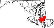
U.S. Highways Categories:- State highways in Maryland
- Roads in Dorchester County, Maryland


Wikimedia Foundation. 2010.