- Maryland Route 335
-
Maryland Route 335
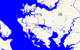
Maryland Route 335 highlighted in redRoute information Maintained by MDSHA Length: 16.36 mi[1] (26.33 km) Major junctions South end: Beginning of state maintenance in Honga  MD 336 in Crossroads
North end:  MD 16 in Church Creek
Location Counties: Dorchester Highway system Maryland highway system
Interstate • US • State • Minor • Former • Turnpikes←  MD 334
MD 336 →Maryland Route 335 (MD 335) is a state highway in the U.S. state of Maryland. The state highway runs 16.36 miles (26.33 km) from Honga on Upper Hooper Island north to MD 16 in Church Creek. MD 335 provides access to several communities along the Honga River in southern Dorchester County, including Hooper's Island. The state highway also passes through Blackwater National Wildlife Refuge. MD 335 was designated as one of the original state roads, but only the portion of the highway from Crossroads to the Blackwater River was completed by 1920. The highway was constructed from Crossroads to Golden Hill in the mid 1920s, from Crossroads to Church Creek in the late 1920s, and from Golden Hill to Hooper's Island with the completion of a modern bridge over Fishing Creek in 1934.
Contents
Route description
MD 335 begins in the village of Honga on Upper Hooper's Island just south of Applegarth Road.[1] Hoopers Island Road continues south through Upper Hooper's Island and Middle Hooper's Island to the villages of Fishing Creek and Hoopersville.[2] MD 335 heads north as Hoopers Island Road on a high-level bridge across Fishing Creek, a strait between Tar Bay and the Honga River.[1][2] After heading north up Meekins Neck, the state highway curves to the east and enters the Great Marsh.[2] Within the marsh, MD 335 intersects Smithville Road at the settlement of Golden Hill between crossings of Great Marsh Creek and Spicer Creek, which flow into the Honga River estuary. The state highway continues southeast where it crosses Wallace Creek before intersecting MD 336 (Lakesville Road) in the hamlet of Crossroads.[1][2] MD 335 turns north onto Golden Hill Road and enters a series of swamps that make up Blackwater National Wildlife Refuge.[1] After the state highway traverses the Blackwater River, the road passes by the Chesapeake Forest Lands and through farmland. MD 335 crosses Birch Dam Creek before entering the town of Church Creek and reaching its northern terminus at MD 16, which is named Church Creek Road north toward Cambridge and Taylors Island Road headed west.[1][2]
History
The section of MD 335 from just north of the Blackwater River to 1 mile (1.6 km) south of Church Creek was paved as a state-aid road by 1921.[3] By 1923, pavement had been added from the southern end of the state-aid section south to Crossroads.[4] The section from Crossroads to Golden Hill was completed in 1925.[5] The section north of Blackwater River was reconstructed and extended to Church Creek by 1930.[6] MD 335 south of Golden Hill was completed in 1933.[7] The last piece of the state highway was a new bridge over Fishing Creek completed in 1934.[8]
Junction list
The entire route is in Dorchester County.
Location Mile[1] Destinations Notes Honga 0.00 Hooper Island Road south – Fishing Creek, Hoopersville Southern terminus Crossroads 6.56 MD 336 east (Lakesville Road) – LakesvilleMD 335 turns north onto Golden Hill Road Church Creek 16.36 MD 16 (Church Creek Road/Taylors Island Road) – Cambridge, Taylors IslandNorthern terminus 1.000 mi = 1.609 km; 1.000 km = 0.621 mi References
- ^ a b c d e f g "Highway Location Reference: Dorchester County" (PDF). Maryland State Highway Administration. 2009. http://www.marylandroads.com/Location/2009_DORCHESTER.pdf. Retrieved 2010-10-20.
- ^ a b c d e Google, Inc. Google Maps – Maryland Route 335 (Map). Cartography by Google, Inc. http://maps.google.com/maps?f=d&source=s_d&saddr=Hoopers+Island+Rd%2FMD-335+N&daddr=Golden+Hill+Rd&geocode=FSohSQIdLd50-w%3BFY5-SwId1AB2-w&hl=en&mra=ls&sll=38.347042,-76.219368&sspn=0.015415,0.038581&ie=UTF8&t=h&z=11. Retrieved 2010-05-07.
- ^ Maryland Geological Survey. Map of Maryland: Showing State Road System and State Aid Roads (Map) (1921 ed.).
- ^ Maryland Geological Survey. Map of Maryland: Showing State Road System and State Aid Roads (Map) (1923 ed.).
- ^ Report of the State Roads Commission of Maryland. 1924-1926. Baltimore: Maryland State Roads Commission. January 1927. p. 100. http://www.archive.org/details/annualreportsofs1924mary. Retrieved 2010-05-14.
- ^ Maryland Geological Survey. Map of Maryland Showing State Road System: State Aid Roads and Improved County Road Connections (Map) (1930 ed.).
- ^ Maryland Geological Survey. Map of Maryland Showing State Road System: State Aid Roads and Improved County Road Connections (Map) (1933 ed.).
- ^ Report of the State Roads Commission of Maryland. 1931-1934. Baltimore: Maryland State Roads Commission. 1934-12-28. p. 332. http://www.archive.org/details/reportofstateroa1931mary. Retrieved 2010-05-14.
External links
Roads in Dorchester County, Maryland State highways 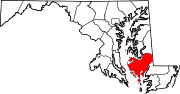
U.S. Highways Categories:- State highways in Maryland
- Roads in Dorchester County, Maryland


Wikimedia Foundation. 2010.