- Maryland Route 300
-
Maryland Route 300
Route information Maintained by MDSHA Length: 13.55 mi[1] (21.81 km)
2 sectionsMajor junctions West end:  MD 213 in Church Hill
 MD 19 in Church Hill
 US 301 near Dudley Corners
 MD 290 in Dudley Corners
 MD 313 in Sudlersville
East end:  DE 300 at the Delaware state line
Location Counties: Queen Anne's Highway system Maryland highway system
Interstate • US • State • Minor • Former • Turnpikes←  MD 299
US 301 →Maryland Route 300 (MD 300) is a state highway in the U.S. state of Maryland. Known for most of its length as Sudlersville Road, the state highway runs 13.55 miles (21.81 km) from MD 213 in Church Hill east to the Delaware state line, where the highway continues as Delaware Route 300 (DE 300). MD 300, which connects Church Hill with Sudlersville in northern Queen Anne's County, is officially separated into two sections, MD 300 and MD 300A, separated by a superstreet intersection with U.S. Route 301 (US 301). MD 300 is a part of the National Highway System between US 301 and the Delaware state line.[2] MD 300 between Church Hill and Dudley Corners was one of the original state roads marked for improvement in 1909. The highway was completed between Church Hill and Sudlersville around 1920. MD 300 between Sudlersville and the Delaware state line was constructed in the late 1920s and early 1930s.
Contents
Route description
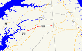
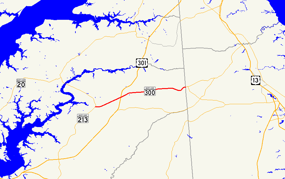
MD 300 begins at an intersection with MD 213 (Church Hill Road) in Church Hill. The highway, officially MD 300A, heads east as two-lane Sudlersville Road and intersects MD 19 (Main Street) before leaving the town and heading northeast through farmland. The state highway intersects US 301 (Blue Star Memorial Highway) at a superstreet intersection.[1][3] Traffic on MD 300 is required to turn right onto US 301, perform a U-turn, then turn right again to continue on MD 300. Now officially MD 300, the highway continues northeast before curving east at the crossing of Red Lion Branch and intersecting MD 290 (Crumpton Road) and Benton Corners Road at Dudley Corners. The state highway heads east to the town of Sudlersville, where the highway's name changes to Main Street. MD 300 intersects MD 837 (Church Circle) and MD 313 (Church Street) before crossing the Centreville Branch of the Northern Line of the Maryland and Delaware Railroad. MD 300 becomes Sudlersville Road again upon leaving town, crossing Unicorn Branch and intersecting Duhamel Corner Road. The state highway passes through a mix of farmland and forest as it meets Peters Corner Road and crosses Andover Branch. MD 300 curves to the northeast at Busic Church Road to its eastern terminus at the Delaware state line. Sudlersville Road continues east as DE 300 toward Kenton and Smyrna.[1][4]
History
The portion of MD 300 between Church Hill and Dudley Corners was designated one of the original state roads, as part of a connection to Crumpton, by the Maryland State Roads Commission in 1909.[5] By 1915, this segment was uncompleted, but the segment of the highway between Dudley Corners and Sudlersville was completed as a state aid road.[6] The link between Church Hill and Dudley Corners was completed between 1919 and 1921.[7][8] The section between Sudlersville and the Delaware state line was started in 1926 with the paving of Main Street east of MD 313 in Sudlersville completed in 1927.[9][10] The highway was extended to Duhamel Corner Road in 1928, to Peters Corner Road in 1930, and to the state line by 1933.[11][12][13] When MD 213's bypass of Church Hill was completed in 1971, MD 300 was extended west to its present terminus.[14] MD 300A was designated along the portion of MD 300 west of US 301 when the superstreet intersection between the two highways was installed in 2005.[15]
Junction list
The entire route is in Queen Anne's County.
Location Mile[1] Intersection Notes Church Hill 0.00 MD 213 (Church Hill Road) – Centreville, ChestertownWestern terminus of MD 300A 0.16 MD 19 (Main Street) – InglesideOld alignment of MD 213 3.92 US 301 (Blue Star Memorial Highway) – Bay Bridge, WilmingtonSuperstreet intersection; eastern terminus of MD 300A; western terminus of MD 300 Dudley Corners 5.52 MD 290 north (Dudley Corner Road) / Benton Corners Road – CrumptonSudlersville 7.28  MD 837 north (Church Circle)
7.34 MD 313 (Church Street) – Millington, Barclay13.55 DE 300 east (Sudlersville Road) – Kenton, DE, Smyrna, DEEastern terminus of MD 300; Delaware state line 1.000 mi = 1.609 km; 1.000 km = 0.621 mi References
- ^ a b c d "Highway Location Reference: Queen Anne's County" (PDF). Maryland State Highway Administration. 2009. http://www.marylandroads.com/Location/2009_QUEENANNES.pdf. Retrieved 2010-09-28.
- ^ Federal Highway Administration (August 2003) (PDF). National Highway System: Maryland (Map). http://www.fhwa.dot.gov/planning/nhs/maps/md/md_Maryland.pdf. Retrieved 2010-09-28.
- ^ Google, Inc. Google Maps – Maryland Route 300A (Map). Cartography by Google, Inc. http://maps.google.com/maps?f=d&source=s_d&saddr=Sudlersville+Rd&daddr=MD-300+E%2FSudlersville+Rd&geocode=FUZdVQIdVJx4-w%3BFfm7VQIdiZZ5-w&hl=en&mra=ls&sll=39.168999,-75.929689&sspn=0.030543,0.077162&ie=UTF8&ll=39.160814,-75.949688&spn=0.030547,0.077162&t=h&z=14. Retrieved 2010-09-28.
- ^ Google, Inc. Google Maps – Maryland Route 300 (Map). Cartography by Google, Inc. http://maps.google.com/maps?f=d&source=s_d&saddr=MD-300+E%2FSudlersville+Rd&daddr=MD-300+E%2FSudlersville+Rd&geocode=Ffm7VQIdiZZ5-w%3BFcUiVgIdVxx8-w&hl=en&mra=ls&sll=39.193815,-75.747943&sspn=0.015266,0.038581&ie=UTF8&t=h&z=12. Retrieved 2010-09-28.
- ^ Report of the State Roads Commission of Maryland. 1927-1930. Baltimore: Maryland State Roads Commission. 1930-10-01. pp. 20–21. http://www.archive.org/details/reportofstateroa1927mary. Retrieved 2010-09-28.
- ^ Report of the State Roads Commission of Maryland. 1912-1915. Baltimore: Maryland State Roads Commission. May 1915. pp. 54, 124. http://www.archive.org/details/annualreportsofs1912mary. Retrieved 2010-09-28.
- ^ Report of the State Roads Commission of Maryland. 1916-1919. Baltimore: Maryland State Roads Commission. January 1920. p. 47. http://www.archive.org/details/annualreportsofs1916mary. Retrieved 2010-09-28.
- ^ Maryland Geological Survey. Map of Maryland: Showing State Road System and State Aid Roads (Map) (1921 ed.).
- ^ Report of the State Roads Commission of Maryland. 1924-1926. Baltimore: Maryland State Roads Commission. January 1927. pp. 33, 95. http://www.archive.org/details/annualreportsofs1924mary. Retrieved 2010-09-28.
- ^ Maryland Geological Survey. Map of Maryland: Showing State Road System and State Aid Roads (Map) (1927 ed.).
- ^ Maryland Geological Survey. Map of Maryland: Showing State Road System and State Aid Roads (Map) (1928 ed.).
- ^ Maryland Geological Survey. Map of Maryland Showing State Road System: State Aid Roads and Improved County Road Connections (Map) (1930 ed.).
- ^ Maryland Geological Survey. Map of Maryland Showing State Road System: State Aid Roads and Improved County Road Connections (Map) (1933 ed.).
- ^ Maryland State Roads Commission. Maryland: Official Highway Map (Map) (1971 ed.).
- ^ "Highway Location Reference: Queen Anne's County" (PDF). Maryland State Highway Administration. 2005. http://www.marylandroads.com/Location/2005_QUEENANNES.pdf. Retrieved 2010-09-28.
External links
Roads in Queen Anne's County, Maryland State highways 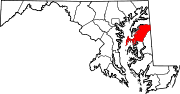
U.S. Highways Categories:- State highways in Maryland
- Roads in Queen Anne's County, Maryland


Wikimedia Foundation. 2010.