- Delaware Route 300
-
Delaware Route 300
Route information Maintained by DelDOT Length: 11.83 mi[1] (19.04 km) Major junctions West end:  MD 300 near Everetts Corner
 DE 44 in Everetts Corner
 DE 11 west of Kenton
 DE 42 in Kenton
 DE 15 southwest of Clayton
 DE 6 in Smyrna
East end:  US 13 / DE 6 in Smyrna
Highway system ←  DE 299
US 301  →
→Delaware Route 300 is a state highway in Kent County, Delaware. The route is a continuation of Maryland Route 300 from the Maryland border near Everetts Corner. It runs in a northeast direction from there to Smyrna, where it ends at U.S. Route 13. The road was first built as a state highway in the 1920s and 1930s between the Maryland border and Clayton, with the DE 300 designation given to the road by 1936. The route was extended to its current terminus in the 1950s.
Contents
Route description
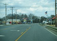 DE 6/DE 300 eastbound approaching US 13 in Smyrna
Delaware Route 300 heads east from the Maryland border on Sudlersville Road. Just across the state line, the route intersects the western terminus of Delaware Route 44 in Everetts Corner. It then heads east through farmland and intersects the northern terminus of Delaware Route 11. It then heads into the town of Kenton, where it is known as Main Street. It intersects Delaware Route 42 within Kenton. Past Kenton, DE 300 heads to the northeast on Wheatleys Pond Road. Midway between Kenton and Clayton, it features a brief concurrency with Delaware Route 15. DE 300 then heads north toward Clayton, passing to the south of the center of the town. Between Clayton and Smyrna, Delaware Route 6 merges onto DE 300, and the two routes head northeast through the northern part of Smyrna on Glenwood Avenue. The road ends at U.S. Route 13, where DE 300 finds its eastern terminus and DE 6 makes a right turn to overlap with US 13.[1][2]
History
By 1920, what is now DE 300 existed as an unimproved county road.[3] The road was completed as a state highway between Kenton and Clayton and was proposed as one west of Kenton by 1924.[4] By 1931, the entire route between Clayton and the Maryland border was completed as a state highway.[5] When Delaware created its state highway system by 1936, DE 300 was routed on its current alignment between the Maryland border and an intersection with DE 6 between Clayton and Smyrna.[6] By 1954, DE 300 was extended east to its present terminus at US 13 in Smyrna.[7]
Major intersections
The entire route is in Kent County.
Location Mile[1] Road Notes 0.00 MD 300 west (Sudlersville Road)Maryland state line, western terminus Everetts Corner 0.33 DE 44 east (Everetts Corner Road)4.54 DE 11 south (Arthursville Road)Kenton 5.32 DE 42 (Commerce Street) DE 15 south (Mt. Friendship Road)West end of DE 15 overlap DE 15 north (Alley Corner Road)East end of DE 15 overlap Smyrna 10.73 DE 6 west (Main Street)West end of DE 6 overlap 11.83 US 13 / DE 6 east (Dupont Boulevard)Eastern terminus 1.000 mi = 1.609 km; 1.000 km = 0.621 mi See also
 U.S. Roads portal
 Delaware portal
References
- ^ a b c http://www.deldot.gov/information/pubs_forms/manuals/traffic_counts/2006/pdf/rpt_pgs1_38_rev.pdf DelDOT 2006 Traffic Count and Mileage Report
- ^ Google, Inc. Google Maps – overview of Delaware Route 300 (Map). Cartography by Google, Inc. http://maps.google.com/maps?f=d&source=s_d&saddr=delaware+300+and+maryland+300&daddr=us+13+and+delaware+300&hl=en&geocode=FdMiVgIdmhx8-ym_Ge7SNoLHiTFrpGXqP-ed8A%3BFRrDVwIdfFR--ykV-EtSOHHHiTHsRzUFWUOgTA&mra=ls&sll=39.293923,-75.614433&sspn=0.114251,0.338173&ie=UTF8&ll=39.252727,-75.679665&spn=0.114318,0.338173&t=h&z=12. Retrieved 2010-08-22.
- ^ Delaware Department of Transportation (PDF). Delaware Official Highway Map (Map) (1920 ed.). http://www.deldot.gov/archaeology/historic_pres/historic_highway_maps/pdf/cd_002.pdf. Retrieved 2010-04-15.
- ^ Delaware Department of Transportation (PDF). Delaware Official Highway Map (Map) (1924 ed.). http://www.deldot.gov/archaeology/historic_pres/historic_highway_maps/pdf/cd_003.pdf. Retrieved 2010-08-01.
- ^ Delaware Department of Transportation (PDF). Delaware Official Highway Map (Map) (1931 ed.). http://www.deldot.gov/archaeology/historic_pres/historic_highway_maps/pdf/cd_005.pdf. Retrieved 2010-08-19.
- ^ Delaware Department of Transportation (PDF). Delaware Official Highway Map (Map) (1936/37 ed.). http://www.deldot.gov/archaeology/historic_pres/historic_highway_maps/pdf/cd_008.pdf. Retrieved 2010-04-15.
- ^ Delaware Department of Transportation (PDF). Delaware Official Highway Map (Map) (1954/55 ed.). http://www.deldot.gov/archaeology/historic_pres/historic_highway_maps/pdf/cd_028.pdf. Retrieved 2010-08-22.
External links
 Media related to Delaware Route 300 at Wikimedia CommonsCategories:
- State highways in Delaware
- Transportation in Kent County, Delaware


Wikimedia Foundation. 2010.