- Maryland Route 552
-
Maryland Route 552
Dominion Road 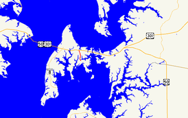
Route information Maintained by MDSHA Length: 2.20 mi[1] (3.54 km) Major junctions South end: Little Creek Road in Dominion  MD 18 in Chester
North end: 
 US 50 / US 301 in Chester
Location Counties: Queen Anne's Highway system Maryland highway system
Interstate • US • State • Minor • Former • Turnpikes←  MD 550
MD 553  →
→Maryland Route 552 (MD 552) is a state highway in the U.S. state of Maryland. The state highway runs 2.20 mi (3.54 km) from Dominion north to U.S. Route 50 and US 301 in Chester. MD 552 was constructed south of Maryland Route 18 (MD 18) in the early 1930s. The state highway was extended north to US 50 and US 301 in the early 1990s.
Contents
Route description
MD 552 begins at a point between First Street and Church Street in the unincorporated village of Dominion. The highway continues south as county-maintained Little Creek Road. MD 552 heads east to an intersection with Parson Island Road, where the state highway turns north.[1][2] The state highway passes through farmland and becomes lined with residences as it approaches an intersection with MD 18 (Main Street) in Chester.[2] MD 552 continues a short distance between shopping centers to its northern terminus at a right-in/right-out interchange with US 50 / US 301 (Blue Star Memorial Highway) at Exit 39B.[1][2]
History
MD 552 was paved starting from MD 18 toward Dominion in two sections that opened in 1933 and 1935, respectively.[3][4][5] MD 552 was extended north to connect with the ramps for Exit 39B of US 50 and US 301 when that highway was upgraded to a freeway around 1991.[6][7]
Junction list
The entire route is in Queen Anne's County.
Location Mile
[1]Destinations Notes Dominion 0.00 Little Creek Road south Southern terminus 0.34 Parson Island Road MD 552 turns north at this intersection Chester 2.11 MD 18 (Main Street) – Stevensville, GrasonvilleOfficially MD 18B 2.20 US 50 east / US 301 north (Blue Star Memorial Highway) – Easton, CentrevilleNorthern terminus; right-in/right-out interchange with eastbound US 50 / US 301 1.000 mi = 1.609 km; 1.000 km = 0.621 mi Auxiliary route
MD 552A is the designation for Chester Station Road, an unsigned 0.08-mile (0.13 km) along the same line as MD 552 on the north side of US 50 and US 301. The state highway runs from a right-in/right-out interchange with westbound US 50 / US 301 at Exit 39B north to Piney Creek Road, which is unsigned MD 18T west of the intersection to the signed mainline of MD 18.[1][8]
References
- ^ a b c d e "Highway Location Reference: Queen Anne's County" (PDF). Maryland State Highway Administration. 2009. http://www.marylandroads.com/Location/2009_QUEENANNES.pdf. Retrieved 2010-09-29.
- ^ a b c Google, Inc. Google Maps – Maryland Route 552 (Map). Cartography by Google, Inc. http://maps.google.com/maps?f=d&source=s_d&saddr=MD-552+N%2FLittle+Creek+Rd&daddr=Dominion+Rd&geocode=FUpHUgIdUAp0-w%3BFci1UgIdmAx0-w&hl=en&mra=ls&sll=38.975583,-76.280753&sspn=0.001906,0.004823&ie=UTF8&t=h&z=14. Retrieved 2010-06-09.
- ^ Maryland Geological Survey. Map of Maryland Showing State Road System: State Aid Roads and Improved County Road Connections (Map) (1933 ed.).
- ^ Report of the State Roads Commission of Maryland. 1931-1934. Baltimore: Maryland State Roads Commission. 1934-12-28. pp. 350–351. http://www.archive.org/details/reportofstateroa1931mary. Retrieved 2010-09-29.
- ^ Maryland Geological Survey. Map of Maryland Showing State Road System: State Aid Roads and Improved County Road Connections (Map) (1935 ed.).
- ^ Maryland State Highway Administration. Maryland: Official Highway Map (Map) (1991 ed.).
- ^ "Highway Location Reference: Queen Anne's County" (PDF). Maryland State Highway Administration. 1999. http://www.marylandroads.com/Location/1999_QUEENANNES.pdf. Retrieved 2010-09-29.
- ^ Google, Inc. Google Maps – Maryland Route 552A (Map). Cartography by Google, Inc. http://maps.google.com/maps?f=d&source=s_d&saddr=Exit+39B&daddr=Piney+Creek+Rd&geocode=FZ-5UgIdWQt0-w%3BFYq8UgIdaAp0-w&hl=en&mra=ls&sll=38.97629,-76.28113&sspn=0.000953,0.002411&ie=UTF8&ll=38.976276,-76.28112&spn=0.000953,0.002411&t=h&z=19. Retrieved 2010-06-09.
External links
Roads in Queen Anne's County, Maryland State highways 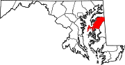
U.S. Highways Categories:- State highways in Maryland
- Roads in Queen Anne's County, Maryland


Wikimedia Foundation. 2010.