- Maryland Route 497
-
Maryland Route 497
Cove Point Road 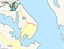
Route information Maintained by MDSHA Length: 2.68 mi[1] (4.31 km) Major junctions West end: 
 MD 2 / MD 4 in Lusby
East end: Cove Point Location Counties: Calvert Highway system Maryland highway system
Interstate • US • State • Minor • Former • Turnpikes←  MD 496
MD 498  →
→Maryland Route 497 (MD 497) is a state highway in the U.S. state of Maryland. Known as Cove Point Road, the state highway runs 2.68 miles (4.31 km) from MD 2 and MD 4 in Lusby east to the community of Cove Point. MD 497 was constructed in the early 1930s.
Contents
Route description
MD 497 begins at an intersection with MD 2 and MD 4, which run concurrently as Solomons Island Road, in Lusby. The state highway heads east as a two-lane road and intersects the old alignment of MD 2, MD 765 (H.G. Trueman Road). MD 497 continues east along Cove Point Park before intersecting Little Cove Point Road, which leads to the Chesapeake Ranch Estates community and the Chesapeake Ranch Airstrip. The state highway passes by the entrance to the Cove Point Liquefied Natural Gas Terminal and through a forested area before reaching its eastern terminus at the entrance to the Cove Point community. The roadway continues as county-maintained Lighthouse Boulevard to the Cove Point Light.[1][2]
History
MD 497 was constructed as a gravel road from MD 2 (now MD 765) to its eastern terminus by 1933.[3] The state highway was extended west to MD 2 and MD 4 when the two highways were relocated from MD 765 to a new divided highway to the west around 1987.[4]
Junction list
The entire route is in Calvert County.
Location Mile[1] Destinations Notes Lusby 0.00 MD 2 / MD 4 (Solomons Island Road) – Prince Frederick, SolomonsWestern terminus 0.25  MD 765 (H.G. Trueman Road)
Officially MD 765Q Cove Point 2.68 Lighthouse Boulevard east Eastern terminus 1.000 mi = 1.609 km; 1.000 km = 0.621 mi References
- ^ a b c "Highway Location Reference: Calvert County" (PDF). Maryland State Highway Administration. 2009. http://www.marylandroads.com/Location/2009_CALVERT.pdf. Retrieved 2011-02-18.
- ^ Google, Inc. Google Maps – Maryland Route 497 (Map). Cartography by Google, Inc. http://maps.google.com/maps?f=d&source=s_d&saddr=Cove+Point+Rd&daddr=Lighthouse+Blvd&hl=en&geocode=FdLDSQIdwq1x-w%3BFTWdSQIdtFpy-w&mra=ls&sll=38.378714,-76.391847&sspn=0.00095,0.002411&ie=UTF8&t=h&z=14. Retrieved 2011-02-18.
- ^ Maryland Geological Survey. Map of Maryland Showing State Road System: State Aid Roads and Improved County Road Connections (Map) (1933 ed.).
- ^ Maryland State Highway Administration. Maryland: Official Highway Map (Map) (1987 ed.).
External links
Roads in Calvert County, Maryland State highways 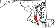 Categories:
- State highways in Maryland
- Roads in Calvert County, Maryland


Wikimedia Foundation. 2010.