- Maryland Route 263
-
Maryland Route 263
Plum Point Road 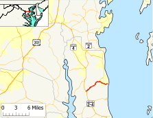
Route information Maintained by MDSHA Length: 6.17 mi[1] (9.93 km) Major junctions West end: 
 MD 2 / MD 4 near Prince Frederick
 MD 261 in Parran
East end: Plum Point Location Counties: Calvert Highway system Maryland highway system
Interstate • US • State • Minor • Former • Turnpikes←  MD 262
MD 264  →
→Maryland Route 263 (MD 263) is a state highway in the U.S. state of Maryland. Known as Plum Point Road, the state highway runs 6.17 miles (9.93 km) from MD 2 and MD 4 near Prince Frederick east to a dead end at Plum Point. MD 263 also connects Prince Frederick with the northeastern Calvert County towns of Chesapeake Beach and North Beach; access to the towns is provided through a connection with MD 261 in Parran. The state highway was constructed in the late 1920s.
Contents
Route description
MD 263 begins at a directional crossover intersection with MD 2 and MD 4, which run concurrently as Solomons Island Road, about 3 miles (4.8 km) north of Prince Frederick. The state highway heads northeast as a two-lane road that immediately crosses Hunting Creek and passes through a forested area with scattered residential subdivisions. MD 263 passes by both ends of its old alignment, which is unsigned MD 761 (Old Plum Point Road), on its way to the community of Parran. Within the community, the state highway intersects Emmanuel Church Road, which leads south to the historic home Cornehill. East of Parran, the roadway continues northeast as MD 261 (Willows Road) toward Chesapeake Beach and North Beach while MD 263 veers east toward Plum Point. MD 263 crosses Plum Point Creek and intersects Wilson Road, which heads south toward Dares Beach, in the community of Plum Point. The state highway intersects Ridge Road, which heads north into the center of the beach community, before it reaches its eastern terminus at a dead end just west of the Chesapeake Bay shoreline.[1][2]
History
MD 263 was constructed as a 15-foot (4.6 m) wide gravel road from MD 2 east to MD 261 in Parran between 1924 and 1927.[3][4] The state highway was constructed to Plum Point in 1929 and 1930.[5][6] MD 263 was widened and paved with bituminous concrete from MD 2 to MD 261 around 1959.[7] The directional crossover intersection at the state highway's western terminus with MD 2 and MD 4 was installed in 2007.[8]
Junction list
The entire route is in Calvert County.
Location Mile[1] Destinations Notes 0.00 MD 2 / MD 4 (Solomons Island Road) – Prince Frederick, Annapolis, Upper MarlboroWestern terminus Parran 4.09 MD 261 north (Willows Road) – Chesapeake BeachPlum Point 6.17 Dead end Eastern terminus 1.000 mi = 1.609 km; 1.000 km = 0.621 mi References
- ^ a b c "Highway Location Reference: Calvert County" (PDF). Maryland State Highway Administration. 2009. http://www.marylandroads.com/Location/2009_CALVERT.pdf. Retrieved 2011-02-17.
- ^ Google, Inc. Google Maps – Maryland Route 263 (Map). Cartography by Google, Inc. http://maps.google.com/maps?f=d&source=s_d&saddr=MD-263+E%2FPlum+Point+Rd&daddr=MD-263+E%2FPlum+Point+Rd&hl=en&geocode=FfK-TAIdTBdv-w%3BFaUfTQIdYH9w-w&mra=ls&sll=38.6093,-76.512394&sspn=0.003789,0.009645&ie=UTF8&t=h&z=13. Retrieved 2011-02-17.
- ^ Report of the State Roads Commission of Maryland. 1924-1926. Baltimore: Maryland State Roads Commission. January 1927. pp. 38, 70. http://www.archive.org/details/annualreportsofs1924mary. Retrieved 2011-02-17.
- ^ Maryland Geological Survey. Map of Maryland: Showing State Road System and State Aid Roads (Map) (1927 ed.).
- ^ Report of the State Roads Commission of Maryland. 1927-1930. Baltimore: Maryland State Roads Commission. 1930-10-01. p. 200. http://www.archive.org/details/reportofstateroa1927mary. Retrieved 2011-02-17.
- ^ Maryland Geological Survey. Map of Maryland Showing State Road System: State Aid Roads and Improved County Road Connections (Map) (1930 ed.).
- ^ Maryland State Roads Commission. Maryland: Official Highway Map (Map) (1959 ed.).
- ^ "Highway Location Reference: Calvert County" (PDF). Maryland State Highway Administration. 2007. http://www.marylandroads.com/Location/2007_CALVERT.pdf. Retrieved 2011-02-17.
External links
Roads in Calvert County, Maryland State highways 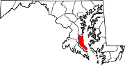 Categories:
- State highways in Maryland
- Roads in Calvert County, Maryland


Wikimedia Foundation. 2010.