- Maryland Route 402
-
Maryland Route 402
Maryland Route 402 highlighted in redRoute information Maintained by MDSHA Length: 4.33 mi[1] (6.97 km) Major junctions West end: 
 MD 2 / MD 4 in Prince Frederick
East end: Chesapeake Avenue in Dares Beach Location Counties: Calvert Highway system Maryland highway system
Interstate • US • State • Minor • Former • Turnpikes←  MD 396
MD 404  →
→Maryland Route 402 (MD 402) is a state highway in the U.S. state of Maryland. Known for most of its length as Dares Beach Road, the state highway runs 4.33 miles (6.97 km) from MD 2 and MD 4 in Prince Frederick east to Chesapeake Avenue in Dares Beach. MD 402 was mostly constructed in 1932. Both termini have changed multiple times; the state highway settled into its present routing in the late 1950s.
Contents
Route description
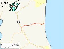
MD 402 begins at an intersection with MD 2 and MD 4, which run concurrently as Solomons Island Road, in the northern end of Prince Frederick. The roadway continues west as West Dares Beach Road to Prince Frederick Boulevard. MD 402 heads east as two-lane Dares Beach Road, which intersects Armory Road and passes the Calvert County Fairgrounds and Calvert High School. The state highway passes through a forested area with scattered residential subdivisions. Between Prince Frederick and Dares Beach, MD 402 intersects Wilson Road, which heads north toward Plum Point. On the western edge of Dares Beach, the old alignment of MD 402, which is unsigned MD 768 (Dares Wharf Road), splits to the northeast. MD 402 continues east as Branch Street to its eastern terminus at Chesapeake Avenue, one block west of the Chesapeake Bay shoreline.[1][2]
History
MD 402 was constructed as a gravel road from MD 2 in Prince Frederick, which originally followed Armory Road, to Wilson Road near Dares Beach in 1932.[3][4] When MD 2 was relocated on the north side of Prince Frederick around 1942, MD 402 was extended south along Armory Road to Main Street (then MD 2, now MD 765).[5][6] The portion of Armory Road north of MD 402 was designated MD 750.[7] In 1957, the state highway was extended east from Wilson Road to Dares Beach using what is now MD 768. MD 402 was removed from Armory Road the same year when the road was transferred to county control.[8] The state highway was reconstructed with a wider bituminous concrete surface starting in 1957 from the Prince Frederick end.[9] The reconstruction was completed in 1959, the same year the highway was extended to its present western terminus at MD 2.[10] MD 402 was rerouted to its present eastern terminus in 1960.[11]
Junction list
The entire route is in Calvert County.
Location Mile[1] Destinations Notes Prince Frederick 0.00 MD 2 / MD 4 (Solomons Island Road) / West Dares Beach Road – Solomons, Annapolis, Upper MarlboroWestern terminus Dares Beach 3.85 Dares Wharf Road north Unsigned MD 768; old alignment of MD 402 4.33 Chesapeake Avenue Eastern terminus 1.000 mi = 1.609 km; 1.000 km = 0.621 mi References
- ^ a b c "Highway Location Reference: Calvert County" (PDF). Maryland State Highway Administration. 2009. http://www.marylandroads.com/Location/2009_CALVERT.pdf. Retrieved 2011-02-17.
- ^ Google, Inc. Google Maps – Maryland Route 402 (Map). Cartography by Google, Inc. http://maps.google.com/maps?f=d&source=s_d&saddr=Dares+Beach+Rd&daddr=MD-402+E%2FDares+Beach+Rd&hl=en&geocode=FZgtTAIdVFVv-w%3BFWRXTAId3nRw-w&mra=ls&sll=38.555998,-76.522828&sspn=0.001896,0.004823&ie=UTF8&t=h&z=14. Retrieved 2011-02-17.
- ^ Report of the State Roads Commission of Maryland. 1931-1934. Baltimore: Maryland State Roads Commission. 1934-12-28. p. 322. http://www.archive.org/details/reportofstateroa1931mary. Retrieved 2011-02-17.
- ^ Maryland Geological Survey. Map of Maryland Showing State Road System: State Aid Roads and Improved County Road Connections (Map) (1933 ed.).
- ^ Report of the State Roads Commission of Maryland. 1941-1942. Baltimore: Maryland State Roads Commission. 1943-03-15. p. 93. http://www.archive.org/details/reportofstateroa1941mary. Retrieved 2011-02-17.
- ^ Maryland State Roads Commission. Maryland: Official Highway Map (Map) (1946-47 ed.).
- ^ Maryland State Roads Commission. Maryland: Official Highway Map (Map) (1950 ed.).
- ^ Maryland State Roads Commission. Maryland: Official Highway Map (Map) (1957 ed.).
- ^ Report of the State Roads Commission of Maryland. 1957-1958. Baltimore: Maryland State Roads Commission. 1958-12-15. p. 73. http://www.archive.org/details/reportofstateroa1957mary. Retrieved 2011-02-17.
- ^ Maryland State Roads Commission. Maryland: Official Highway Map (Map) (1959 ed.).
- ^ Maryland State Roads Commission. Maryland: Official Highway Map (Map) (1960 ed.).
External links
Roads in Calvert County, Maryland State highways  Categories:
- State highways in Maryland
- Roads in Calvert County, Maryland


Wikimedia Foundation. 2010.