- Maryland Route 264
-
Maryland Route 264
Broomes Island Road 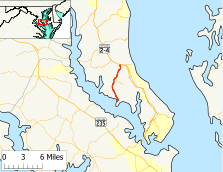
Route information Maintained by MDSHA Length: 6.66 mi[1] (10.72 km) Major junctions South end: Oyster House Road in Broomes Island  MD 265 in Mutual
North end: 
 MD 2 / MD 4 in Port Republic
Location Counties: Calvert County Highway system Maryland highway system
Interstate • US • State • Minor • Former • Turnpikes←  MD 263
MD 265 →Maryland Route 264 (MD 264) is a state highway in the U.S. state of Maryland. Known as Broomes Island Road, the route runs 6.66 miles (10.72 km) from Oyster House Road in Broomes Island north to MD 2 and MD 4 in Port Republic. MD 264 connects the central Calvert County communities of Broomes Island, Island Creek, and Mutual with the county's main highway at Port Republic. The state highway was constructed in the early 1920s.
Contents
Route description
MD 264 begins at the intersection of Ballard Rogers Road and Oyster House Road in Broomes Island. Ballard Rogers Road continues south to the end of the peninsula between Island Creek and the Patuxent River that contains the village of Broomes Island, a former oyster canning center. MD 264 heads north as a two-lane road out of the village through a mix of farmland and forest toward the community of Island Creek, where the highway intersects Parkers Wharf Road and Williams Wharf Road. In the village of Mutual, the state highway intersects MD 265 and Laveille Road, which leads west to the historic home La Veille. North of Mutual, MD 264 passes Christ Church, which with a founded date of 1672 is the oldest church in Calvert County. The state highway passes a spur of old alignment, Yoes Corner Road (unsigned MD 264A), and reaches its northern terminus at a directional crossover intersection with MD 2 and MD 4 (Solomons Island Road) in Port Republic. There is no direct access between MD 264 and MD 765 (St. Leonard Road), which meets the northbound direction of MD 2 and MD 4 at an adjacent right-in/right-out intersection.[1][2]
History
MD 264 was constructed as a gravel road around 1923.[3] The state highway followed the alignment of Yoes Corner Road to MD 2 and MD 4 until the northern end was moved opposite the northern terminus of the St. Leonard – Port Republic segment of MD 765 around 1985.[4] MD 264's northern terminus was changed from a standard intersection to a directional crossover intersection in 2006.[5]
Junction list
The entire route is in Calvert County.
Location Mile[1] Destinations Notes Broomes Island 0.00 Ballard Rogers Road south / Oyster House Road east Southern terminus Mutual 4.42 MD 265 south (Mackall Road) – WallvillePort Republic 6.66 MD 2 / MD 4 (Solomons Island Road) – Prince Frederick, SolomonsNorthern terminus; directional crossover intersection 1.000 mi = 1.609 km; 1.000 km = 0.621 mi Auxiliary route
MD 264A is the designation for Yoes Corner Lane, a 0.19-mile (0.31 km) spur that runs from MD 264 north to a cul-de-sac adjacent to MD 2 and MD 4 just west of MD 264's northern terminus.[1][6]
References
- ^ a b c d "Highway Location Reference: Calvert County" (PDF). Maryland State Highway Administration. 2009. http://www.marylandroads.com/Location/2009_CALVERT.pdf. Retrieved 2011-01-28.
- ^ Google, Inc. Google Maps – Maryland Route 264 (Map). Cartography by Google, Inc. http://maps.google.com/maps?f=d&source=s_d&saddr=MD-264+N%2FBroomes+Island+Rd&daddr=MD-264+N%2FBroomes+Island+Rd&hl=en&geocode=FbYnSgId9Pxv-w%3BFRR2SwIdgiFw-w&mra=ls&sll=38.414196,-76.546893&sspn=0.000482,0.001206&ie=UTF8&t=h&z=12. Retrieved 2011-01-28.
- ^ Maryland Geological Survey. Map of Maryland: Showing State Road System and State Aid Roads (Map) (1923 ed.).
- ^ Maryland State Highway Administration. Maryland: Official Highway Map (Map) (1985-86 ed.).
- ^ "Highway Location Reference: Calvert County" (PDF). Maryland State Highway Administration. 2006. http://www.marylandroads.com/Location/2006_CALVERT.pdf. Retrieved 2011-01-28.
- ^ Google, Inc. Google Maps – Maryland Route 264A (Map). Cartography by Google, Inc. http://maps.google.com/maps?f=d&source=s_d&saddr=MD-264+N%2FBroomes+Island+Rd&daddr=Yoes+Corner+Ln&hl=en&geocode=FeBtSwIdrh1w-w%3BFbR2SwId8Bdw-w&mra=ls&sll=38.499658,-76.538755&sspn=0.003854,0.009645&ie=UTF8&ll=38.498886,-76.539216&spn=0.003854,0.009645&t=h&z=17. Retrieved 2011-01-28.
External links
Roads in Calvert County, Maryland State highways 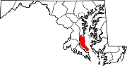 Categories:
- State highways in Maryland
- Roads in Calvert County, Maryland


Wikimedia Foundation. 2010.