- Chesapeake Beach, Maryland
-
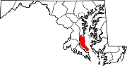
Chesapeake Beach, Maryland — Town — Nickname(s): Twin Beaches (along with North Beach, the adjacent town to the north) Location of Chesapeake Beach, Maryland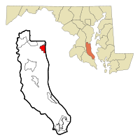
Coordinates: 38°41′42″N 76°32′10″W / 38.695°N 76.53611°WCoordinates: 38°41′42″N 76°32′10″W / 38.695°N 76.53611°W Country United States State Maryland County Calvert Government - Mayor Bruce Wahl Area - Total 2.8 sq mi (7.2 km2) - Land 2.8 sq mi (7.2 km2) - Water 0.0 sq mi (0.0 km2) Elevation 49 ft (15 m) Population (2000) - Total 3,180 - Density 1,144.7/sq mi (442.0/km2) Time zone Eastern (EST) (UTC-5) - Summer (DST) EDT (UTC-4) ZIP code 20732 Area code(s) 301 FIPS code 24-15925 GNIS feature ID 0589951  Map of old Chesapeake Beach Railroad from D.C. to Chesapeake Beach
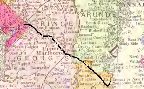
Chesapeake Beach is a town in Calvert County, Maryland, United States. Its major attractions include a Railway Museum & Trail, the Chesapeake Beach Water Park, marinas, piers, charter boat fishing, and a Veterans Memorial Park. In the Census 2000 the population was estimated at 3,180.
Contents
Geography
Chesapeake Beach is located at 38°41′42″N 76°32′10″W / 38.695°N 76.53611°W (38.695070, -76.536125)[1].
According to the United States Census Bureau, the town has a total area of 2.8 square miles (7.3 km2), all of it land.
The city has grown out from the intersection of Fishing Creek and the Chesapeake Bay. The creek has been dredged to allow pleasure craft, commercial fisherman and a few small US Navy vessels to dock in the city.
The southern end of the city remains heavily wooded and is distinguished by the large sandstone cliffs called the Randle Cliffs. These cliffs, and others along the Western Shore of the Chesapeake Bay, tower as high as 180 feet above the water and are constantly eroding due to freeze/thaw and wave action. The debris from these cliffs has formed a number of shallow sand bars which makes navigation by boat near the cliffs very difficult and the water very shallow for hundreds of yards into the Bay.
Demographics
As of the census[2] of 2000, there were 3,180 people, 1,217 households, and 862 families residing in the town. The population density was 1,144.7 people per square mile (441.7/km²). There were 1,331 housing units at an average density of 479.1 per square mile (184.9/km²). The racial makeup of the town was 91.51% White, 5.28% African American, 0.35% Native American, 1.10% Asian, 0.38% from other races, and 1.38% from two or more races. Hispanic or Latino of any race were 1.42% of the population.
There were 1,217 households out of which 35.2% had children under the age of 18 living with them, 52.7% were married couples living together, 12.9% had a female householder with no husband present, and 29.1% were non-families. 21.6% of all households were made up of individuals and 5.4% had someone living alone who was 65 years of age or older. The average household size was 2.61 and the average family size was 3.03.
In the town the population was spread out with 27.2% under the age of 18, 7.4% from 18 to 24, 34.4% from 25 to 44, 24.0% from 45 to 64, and 7.0% who were 65 years of age or older. The median age was 36 years. For every 100 females there were 99.1 males. For every 100 females age 18 and over, there were 93.8 males.
The median income for a household in the town was $68,365, and the median income for a family was $74,167. Males had a median income of $43,125 versus $35,865 for females. The per capita income for the town was $29,616. About 1.6% of families and 3.8% of the population were below the poverty line, including 3.8% of those under age 18 and 5.5% of those age 65 or over.
History
Chesapeake Beach was established as a resort community at the end of the Chesapeake Beach Railway, a short line railroad from Washington, DC. It was the site of many slot machines in the early twentieth century (despite efforts to prohibit them)[3] as part of the "Little Nevada" area of southern Maryland. Between steamer ships from Baltimore and trains from Washington, the weekend population of Chesapeake Beach reached into the 10,000s during the 1920s, until economic depression, and a bad hotel fire, brought an end to the railroad. The construction of the Bay Bridge to the Eastern Shore of Maryland in the 1950s enabled many of the visitors who used to spend their summers in Chesapeake Beach to now spend their time in Ocean City, Maryland instead.[citation needed] A museum at the old railroad station still exists today in Chesapeake Beach with many historic photos and an old passenger car from the railroad. It was listed on the National Register of Historic Places in 1980. In the new millennium a boardwalk and pier, and a new condominium development have risen in Chesapeake Beach. There is also a recreational water park with water slides, a newly-opened resort spa hotel, and a seafood restaurant right on the bay. The Herrington Harbour (Rose Haven) marina resort, which was voted[by whom?] the best marina in the United States, is a few miles north.[citation needed]
Chesapeake Beach is also host to the United States Naval Research Laboratory Chesapeake Bay Detachment that experiments with various military radar systems and fire suppression technology. Perched atop the sandstone cliffs along the Western Shore of the Chesapeake Bay the lab is able to use their radars against a variety of surface and air targets in the Bay. Nearby Naval Air Station Patuxent River has several aircraft that assist in the Research lab's mission.[4]
Hurricane Isabel struck Chesapeake Beach and the adjacent city of North Beach, Maryland in 2003. The storm surge pushed flood waters into both towns, damaging many homes beyond repair in North Beach, and knocking out electrical services for nearly one week.[citation needed]
Notable residents
Thomas V. Mike Miller, Jr., the current president of the Maryland Senate (as of April 2008), lives in Chesapeake Beach.
Tom ClancyReferences
- ^ "US Gazetteer files: 2010, 2000, and 1990". United States Census Bureau. 2011-02-12. http://www.census.gov/geo/www/gazetteer/gazette.html. Retrieved 2011-04-23.
- ^ "American FactFinder". United States Census Bureau. http://factfinder.census.gov. Retrieved 2008-01-31.
- ^ Chesapeake Beach Hotel Co. v. Hall, 121 Md. 643; 89 A. 445 (1913).
- ^ http://www.nrl.navy.mil/field-sites/vxs-1/
Brett Cecil, Current starting pitcher for the Toronto Blue Jays
External links
- Chesapeake Beach Railway Museum
- Chesapeake Beach official website
- Chesapeake Beach Naval Research lab
Municipalities and communities of Calvert County, Maryland County seat: Prince Frederick Towns Chesapeake Beach | North Beach
CDPs Other
communitiesAdelina | Barstow | Bowens | Broomes Island | Chaneyville | Chesapeake Ranch Estates | Dares Beach | Dowell | Johnstown | Lower Marlboro | Mutual | Parran | Pleasant Valley | Port Republic | Scientists Cliffs | Stoakley | Sunderland | Wallville
Categories:- Towns in Maryland
- Populated places in Calvert County, Maryland


Wikimedia Foundation. 2010.