- Maryland Route 234
-
Maryland Route 234
Budds Creek Road 
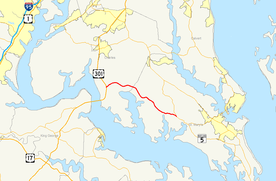
Map of Southern Maryland with MD 234 highlighted in redRoute information Maintained by MDSHA Length: 19.02 mi[1] (30.61 km) Major junctions West end:  US 301 in Allens Fresh
 MD 236 in Budds Creek
 MD 238 in Chaptico
 MD 242 in Clements
East end:  MD 5 in Leonardtown
Location Counties: Charles, St. Mary's Highway system Maryland highway system
Interstate • US • State • Minor • Former • Turnpikes←  MD 231
MD 235  →
→Maryland Route 234 (MD 234) is a state highway in the U.S. state of Maryland. Known as Budds Creek Road, the state highway runs 19.02 miles (30.61 km) from U.S. Route 301 (US 301) in Allens Fresh east to MD 5 in Leonardtown. MD 234 is the primary east–west highway of southern Charles County and western St. Mary's County, connecting the county seat of Leonardtown and the communities of Clements, Chaptico, Budds Creek, Wicomico, and Newport with US 301, which heads north to La Plata and south to the Governor Harry W. Nice Memorial Bridge over the Potomac River.
East of Chaptico, MD 234 originally followed what is now MD 238 east to MD 5 at Helen. The Chaptico–Leonardtown portion of the highway was MD 237. MD 234 was constructed in the early 1920s while MD 237 was built in the late 1920s and early 1930s. MD 237 was between Clements and Leonardtown was reconstructed around 1950. The Chaptico–Clements section of MD 237 and MD 234 west of Chaptico was rebuilt around 1960, a project that involved many relocations and several new bridges. At the conclusion of the project in 1961, MD 234 was extended east over MD 237 to Leonardtown and MD 238 was extended from Chaptico to Helen.
Contents
Route description
MD 234 begins at a directional crossover intersection with US 301 (Robert Crain Highway) about 4 miles (6.4 km) north of the Potomac River Bridge. The state highway heads east as a two-lane road, crossing over CSX's Popes Creek Subdivision and passes through the hamlet of Allens Fresh. MD 234 crosses Allens Fresh Run, a tributary of the Wicomico River, as the stream flows out of the southern end of Zekiah Swamp, which is preserved within Zekiah Swamp Natural Environment Area. The state highway passes through the community of Newport, home of St. Mary's Roman Catholic Church, and crosses Gilbert Swamp Run into the hamlet of Wicomico, which contains the historic home Sarum. MD 234 leaves Charles County by crossing over Budds Creek.[1][2]
MD 234 curves southeast through the hamlet of Budds Creek, where the highway meets the southern end of MD 236 (Thompsons Corner Road) and passes three motorsports facilities: Maryland International Speedway, Budds Creek Motocross, and Potomac Speedway. The state highway continues southeast, passing by Wicomico Shores Country Club and its associated residential area separated from the highway by a large tract of forest. MD 234 crosses Hayden Run and passes through Chaptico, where the highway intersects MD 238 at a roundabout. MD 238 heads northeast as Chaptico Road and southwest as Maddox Road. The state highway passes another historic home, Deep Falls, on the way to Clements. After intersecting MD 242 (Colton Point Road), which leads south to the site of Maryland's First Landing at St. Clement's Island. MD 234 crosses Clements Creek and heads east through farmland, crossing Nelson Run right before the highway reaches its eastern terminus at MD 5 (Point Lookout Road) on the western edge of Leonardtown.[1][2]
History
MD 234 originally followed roughly its current course from Allens Fresh to Chaptico, then followed what is now MD 238 east to MD 5 at Helen. The highway between Chaptico and Leonardtown via Clements was MD 237.[3] MD 234 was constructed as a gravel road from Allens Fresh east to Newport around 1921.[4] The highway was extended east to the St. Mary's County line in 1923. The Chaptico–Helen road, as well as 1 mile (1.6 km) of road west of Chaptico, were also constructed in 1923.[5] The original course of MD 234 was completed when the gap between Chaptico and the county line at Budds Creek was filled in 1925.[6][7] MD 237 was started between Clements and Leonardtown in 1924 and between Chaptico and Clements in 1926.[6] By 1927, there was two 1-mile (1.6 km) sections of gravel east from Chaptico and east from Clements.[7] Another section of highway west from Clements was built in 1928.[8] By 1930, MD 237 was complete from Clements to Leonardtown.[9] The gap between Chaptico and Clements was under construction in 1930 and completed in 1932.[10][11][12]
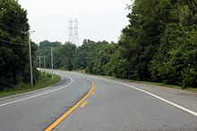 Westbound MD 234 approaching US 301 in Allens Fresh
The first upgrade of MD 234 was a relocation at Allens Fresh Run, which included replacing a dangerous one-way bridge over the stream, that was completed in 1933.[12][13] MD 237 was reconstructed with a bituminous stabilized gravel surface between Clements and Leonardtown in 1950 and 1951, a project that included new bridges over Clements Creek at a spot known as Head-of-the-Bay and over Nelson Run near Leonardtown.[14][15] Reconstruction of MD 234 from Allens Fresh to Chaptico and MD 237 from there to Clements occurred between 1959 and 1961. MD 234 and MD 237 were significantly straightened out, leaving behind many sections of old alignment: Glasva School Road in Allens Fresh; Allens Fresh Road between Allens Fresh and Newport; Stines Store Road in Newport; Plater Road and Olde Mill Road in Wicomico; Stone Corner Lane, which is unsigned MD 868G, and Reed Road in Budds Creek; and Horse Shoe Road between Chaptico and Clements.[16][17] The project also involved new bridges over Gilbert Swamp Run, Chaptico Creek, and Budds Creek.[18][19][20] When the project was completed in 1961, MD 234 assumed the course of MD 237 between Chaptico and Leonardtown and MD 238 was extended over the segment of MD 234 between Chaptico and Helen.[21]
The first roundabout in St. Mary's County was installed at the intersection of MD 238 and MD 234 in Chaptico in 2007.[22][23] In September 2011, MD 234's bridge over Allens Fresh Run was partially washed out by flooding of the creek due to torrential rainfall from the remnants of Tropical Storm Lee.[24] Until a temporary bridge is completed parallel to the damaged section in November 2011, traffic is being detoured over MD 236, MD 6, and US 301.[25] The Maryland State Highway Administration plans to dismantle the damaged 40-foot (12 m) long bridge and build a 100-foot (30 m) long replacement bridge in 2012.[24][25]
Junction list
County Location Mile
[1]Destinations Notes Charles Allens Fresh 0.00 US 301 (Robert Crain Highway) – La Plata, Potomac River BridgeWestern terminus St. Mary's Budds Creek 7.24 MD 236 north (Thompsons Corner Road) – Charlotte HallChaptico 11.28 MD 238 (Maddox Road/Chaptico Road) – Maddox, HelenRoundabout Clements 15.52 MD 242 (Colton Point Road) – Coltons Point, MorganzaLeonardtown 19.02 MD 5 (Point Lookout Road) – Point Lookout, WaldorfEastern terminus 1.000 mi = 1.609 km; 1.000 km = 0.621 mi References
- ^ a b c d Maryland State Highway Administration (2010). Highway Location Reference. http://www.marylandroads.com/pages/hlr.aspx?PageId=832. Retrieved 2011-10-07.
- Charles County (PDF)
- St. Mary's County (PDF)
- ^ a b Google, Inc. Google Maps – Maryland Route 234 (Map). Cartography by Google, Inc. http://maps.google.com/maps?f=d&source=s_d&saddr=MD-234+E%2FBudds+Creek+Rd&daddr=MD-234+E%2FBudds+Creek+Rd&hl=en&geocode=FS4NSgIdLMlp-w%3BFYKcSAId3CNu-w&mra=ls&sll=38.407027,-76.950817&sspn=0.015436,0.038581&ie=UTF8&ll=38.374501,-76.769028&spn=0.247083,0.617294&t=h&z=11. Retrieved 2011-01-14.
- ^ Maryland State Roads Commission. General Highway Map: State of Maryland (Map) (1939 ed.).
- ^ Maryland Geological Survey. Map of Maryland: Showing State Road System and State Aid Roads (Map) (1921 ed.).
- ^ Maryland Geological Survey. Map of Maryland: Showing State Road System and State Aid Roads (Map) (1923 ed.).
- ^ a b Report of the State Roads Commission of Maryland. 1924-1926. Baltimore: Maryland State Roads Commission. January 1927. pp. 36–37, 77, 96–97. http://www.archive.org/details/annualreportsofs1924mary. Retrieved 2011-01-14.
- ^ a b Maryland Geological Survey. Map of Maryland: Showing State Road System and State Aid Roads (Map) (1927 ed.).
- ^ Maryland Geological Survey. Map of Maryland: Showing State Road System and State Aid Roads (Map) (1928 ed.).
- ^ Maryland Geological Survey. Map of Maryland Showing State Road System: State Aid Roads and Improved County Road Connections (Map) (1930 ed.).
- ^ Report of the State Roads Commission of Maryland. 1927-1930. Baltimore: Maryland State Roads Commission. 1930-10-01. pp. 207, 227. http://www.archive.org/details/reportofstateroa1927mary. Retrieved 2011-01-14.
- ^ Maryland Geological Survey. Map of Maryland Showing State Road System: State Aid Roads and Improved County Road Connections (Map) (1933 ed.).
- ^ a b Report of the State Roads Commission of Maryland. 1931-1934. Baltimore: Maryland State Roads Commission. 1934-12-28. pp. 44, 352. http://www.archive.org/details/reportofstateroa1931mary. Retrieved 2011-01-14.
- ^ "NBI Structure Number: 100000080037010". National Bridge Inventory. http://nationalbridges.com/. Retrieved 2011-01-14.
- ^ Report of the State Roads Commission of Maryland. 1951-1952. Baltimore: Maryland State Roads Commission. 1952-12-15. pp. 173, 177–178. http://www.archive.org/details/reportofstateroa1951mary. Retrieved 2011-01-14.
- ^ "NBI Structure Number: 100000180037030". National Bridge Inventory. http://nationalbridges.com/. Retrieved 2011-01-14.
- ^ Maryland State Roads Commission. Maryland: Official Highway Map (Map) (1959 ed.).
- ^ United States Geological Survey. Wicomico, MD quadrangle (Map). 1:48,000. 15 Minute Series (Topographic) (1914 ed.). http://historical.mytopo.com/quad.cfm?quadname=Wicomico&state=MD&series=15. Retrieved 2011-01-14.
- ^ "NBI Structure Number: 100000080047010". National Bridge Inventory. http://nationalbridges.com/. Retrieved 2011-01-14.
- ^ "NBI Structure Number: 100000180015010". National Bridge Inventory. http://nationalbridges.com/. Retrieved 2011-01-14.
- ^ "NBI Structure Number: 100000180014020". National Bridge Inventory. http://nationalbridges.com/. Retrieved 2011-01-14.
- ^ Maryland State Roads Commission. Maryland: Official Highway Map (Map) (1961 ed.).
- ^ Johnson, Jenna (2007-10-18). "Traffic Circle Has Drivers in a Spin". The Washington Post (Washington, DC: The Washington Post Company). http://www.washingtonpost.com/wp-dyn/content/article/2007/10/17/AR2007101702412.html. Retrieved 2010-12-08.
- ^ "Highway Location Reference: St. Mary's County" (PDF). Maryland State Highway Administration. 2007. http://www.marylandroads.com/Location/2007_SAINTMARYS.pdf. Retrieved 2010-12-08.
- ^ a b Newman, Jeff (2011-09-14). "Route 234 remains closed at Allens Fresh". The Maryland Independent (Waldorf, MD: Southern Maryland Newspapers). http://www.somdnews.com/article/20110914/NEWS/709149688&template=southernMaryland. Retrieved 2011-10-07.
- ^ a b Mitrano, Erica (2011-10-05). "Route 234 Allens Fresh bridge delayed until late November". The Maryland Independent (Waldorf, MD: Southern Maryland Newspapers). http://www.somdnews.com/article/20111005/NEWS/710059677&template=southernMaryland. Retrieved 2011-10-07.
External links
Roads in Charles County, Maryland State highways 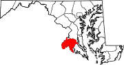
U.S. Highways Roads in St. Mary's County, Maryland State highways  Categories:
- State highways in Maryland
- Roads in Charles County, Maryland
- Roads in St. Mary's County, Maryland
- ^ a b c d Maryland State Highway Administration (2010). Highway Location Reference. http://www.marylandroads.com/pages/hlr.aspx?PageId=832. Retrieved 2011-10-07.


Wikimedia Foundation. 2010.