- Maryland Route 471
-
Maryland Route 471
Indian Bridge Road 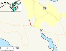
Route information Maintained by MDSHA Length: 1.01 mi[1] (1.63 km) Major junctions South end:  MD 5 in Great Mills
North end: St. Mary's River near Great Mills Location Counties: St. Mary's County Highway system Maryland highway system
Interstate • US • State • Minor • Former • Turnpikes←  MD 470
MD 472  →
→Maryland Route 471 (MD 471) is a state highway in the U.S. state of Maryland. Known as Indian Bridge Road, the state highway runs 1.01 miles (1.63 km) from Maryland Route 5 north to a crossing of the St. Marys River within Great Mills. MD 471 was constructed in two segments in the early 1930s. The second segment near Leonardtown was removed from the state highway system in the mid 1950s but returned as an extension of MD 4 in the early 1980s.
Contents
Route description
MD 471 begins at an intersection with MD 5 (Point Lookout Road) and Flat Iron Road in Great Mills. The state highway heads north as an 18-foot (5.5 m) wide two-lane road north through a forested area. MD 471 passes through the cluster of four buildings that is Cecil's Mill Historic District. The state highway continues northwest, crossing the St. Mary's River twice. MD 471 reaches its northern terminus at the northern end of the second bridge over the river. Indian Bridge Road continues northwest as a county highway toward St. Mary's River State Park and an intersection with MD 4 (St. Andrews Church Road) between Leonardtown and California.[1][2]
History
MD 471 was constructed in two disjoint segments in 1932: the current length of the state highway along Indian Bridge Road and St. Andrews Church Road between MD 5 and Fairgrounds Road near Leonardtown.[3][4] The latter segment of MD 471 was removed from the state highway system in 1956 but returned when MD 4 was extended west from California to Leonardtown in 1982.[5][6] The current portion of MD 471 was also transferred to county control in 1956 but returned to the state highway system by 1963.[5][7]
Junction list
The entire route is in Great Mills in St. Mary's County.
Mile[1] Destinations Notes 0.00 MD 5 (Point Lookout Road) / Flat Iron Road south – St. Mary's City, LeonardtownSouthern terminus 1.01 Indian Bridge Road north Northern terminus; end of state maintenance at St. Marys River 1.000 mi = 1.609 km; 1.000 km = 0.621 mi References
- ^ a b c "Highway Location Reference: St. Mary's County" (PDF). Maryland State Highway Administration. 2009. http://www.marylandroads.com/Location/2009_SAINTMARYS.pdf. Retrieved 2010-12-16.
- ^ Google, Inc. Google Maps – Maryland Route 471 (Map). Cartography by Google, Inc. http://maps.google.com/maps?f=d&source=s_d&saddr=MD-471%2FIndian+Bridge+Rd&daddr=MD-471%2FIndian+Bridge+Rd&hl=en&geocode=FaB1RwIdELFw-w%3BFXmpRwIdVpVw-w&mra=ls&sll=38.250655,-76.507665&sspn=0.000967,0.002411&ie=UTF8&t=h&z=15. Retrieved 2010-12-16.
- ^ Maryland Geological Survey. Map of Maryland Showing State Road System: State Aid Roads and Improved County Road Connections (Map) (1933 ed.).
- ^ Report of the State Roads Commission of Maryland. 1931-1934. Baltimore: Maryland State Roads Commission. 1934-12-28. p. 352. http://www.archive.org/details/reportofstateroa1931mary. Retrieved 2010-12-16.
- ^ a b Maryland State Roads Commission. Maryland: Official Highway Map (Map) (1956 ed.).
- ^ "Traffic Volume Map" (PDF). Maryland State Highway Administration. 1982. http://www.marylandroads.com/Traffic_Volume_Maps/82_Traffic_Volume_Maps.pdf. Retrieved 2010-12-16.
- ^ Maryland State Roads Commission. Maryland: Official Highway Map (Map) (1963 ed.).
External links
Roads in St. Mary's County, Maryland State highways  Categories:
- State highways in Maryland
- Roads in St. Mary's County, Maryland


Wikimedia Foundation. 2010.