- Maryland Route 236
-
Maryland Route 236
Thompsons Corner Road 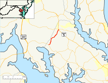
Map of Southern Maryland with MD 236 highlighted in redRoute information Maintained by MDSHA Length: 6.19 mi[1] (9.96 km) Major junctions South end:  MD 234 in Budds Creek
North end:  MD 5 in Charlotte Hall
Location Counties: St. Mary's Highway system Maryland highway system
Interstate • US • State • Minor • Former • Turnpikes←  MD 235
MD 237  →
→Maryland Route 236 (MD 236) is a state highway in the U.S. state of Maryland. Known as Thompsons Corner Road, the state highway runs 6.19 miles (9.96 km) from MD 234 in Budds Creek north to MD 5 in Charlotte Hall. MD 236 parallels the western edge of St. Mary's County, connecting Charlotte Hall with U.S. Route 301 via MD 234. The state highway was constructed in the early 1930s.
Contents
Route description
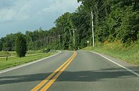 MD 236 northbound in St. Mary's County
MD 236 begins at an intersection with MD 234 (Budds Creek Road) in the hamlet of Budds Creek, which is the site of a trio of racing facilities: Maryland International Speedway, Budds Creek Motocross, and Potomac Speedway. The state highway intersects the old alignment of MD 234, Stone Corner Lane (unsigned MD 868G), and heads northeast as a two-lane road through farmland. MD 236 intersects Lockes Crssing Road in the hamlet of Thompson Corner. The state highway continues north to Charlotte Hall, where the highway crosses the Three Notch Trail at grade and meets New Market Village Road. New Market Village Road to the north, which is the old alignment of MD 236 and is unsigned MD 236A, heads through the hamlet of Newmarket toward the Charlotte Hall Historic District. MD 236 curves to the east to its northern terminus at MD 5 (Three Notch Road), which intersects the highway at two separate intersections separated by a wide median containing businesses.[1][2]
History
MD 236 was constructed as a gravel road starting in 1929 from the north end.[3] By 1930, a small segment of the highway was completed south from Charlotte Hall.[3][4] MD 236 was completed in 1933 from Budds Creek to Charlotte Hall, albeit with a county-maintained gap between Wainwright Road and Ryceville Road toward the Budds Creek end.[5][6] The portion of Thompsons Corner Road in the county system was transferred to the state highway system in 1956.[7] MD 236 originally continued north along what is now MD 236A to its northern terminus at an acute intersection with MD 5 just south of the MD 5–MD 6 intersection in Charlotte Hall.[8] When MD 5 was expanded to a divided highway through Charlotte Hall in 1962, MD 236 remained accessible only from southbound MD 5; traffic from northbound MD 5 needed to make a U-turn at MD 6 to access MD 236.[8][9] The northern end of MD 236 was relocated to its present perpendicular intersections with the opposing directions of MD 5 between 1981 and 1993.[8][10]
Junction list
The entire route is in St. Mary's County.
Location Mile[1] Destinations Notes Budds Creek 0.00  MD 234 (Budds Creek Road) to US 301 – Leonardtown
Southern terminus Charlotte Hall 6.06 New Market Village Road New Market Village Road north is unsigned MD 236A 6.15 MD 5 south (Three Notch Road) – Leonardtown, Lexington Park6.19 MD 5 north (Three Notch Road) – Hughesville, WaldorfNorthern terminus 1.000 mi = 1.609 km; 1.000 km = 0.621 mi Auxiliary route
MD 236A is the designation for New Market Village Road, a 0.18-mile (0.29 km) section of old alignment of MD 236 north through the village of Newmarket to an intersection with southbound MD 5 just south of MD 5's intersection with MD 6.[1][11]
References
- ^ a b c d "Highway Location Reference: St. Mary's County" (PDF). Maryland State Highway Administration. 2009. http://www.marylandroads.com/Location/2009_SAINTMARYS.pdf. Retrieved 2010-12-06.
- ^ Google, Inc. Google Maps – Maryland Route 236 (Map). Cartography by Google, Inc. http://maps.google.com/maps?f=d&source=s_d&saddr=MD-234+E%2FBudds+Creek+Rd&daddr=Thompsons+Corner+Rd&hl=en&geocode=FZ73SQIdFqFr-w%3BFWgCSwIdYIls-w&mra=ls&sll=38.470189,-76.774092&sspn=0.007711,0.01929&ie=UTF8&t=h&z=12. Retrieved 2010-12-06.
- ^ a b Report of the State Roads Commission of Maryland. 1927-1930. Baltimore: Maryland State Roads Commission. 1930-10-01. pp. 226–227. http://www.archive.org/details/reportofstateroa1927mary. Retrieved 2010-12-07.
- ^ Maryland Geological Survey. Map of Maryland Showing State Road System: State Aid Roads and Improved County Road Connections (Map) (1930 ed.).
- ^ Maryland Geological Survey. Map of Maryland Showing State Road System: State Aid Roads and Improved County Road Connections (Map) (1933 ed.).
- ^ Maryland State Roads Commission. General Highway Map: State of Maryland (Map) (1939 ed.).
- ^ Maryland State Roads Commission. Maryland: Official Highway Map (Map) (1956 ed.).
- ^ a b c United States Geological Survey (1981-07-01). 1 km NE of Thompson Corner, Maryland, United States (Map). Topo Map. http://msrmaps.com/image.aspx?T=2&S=13&Z=18&X=215&Y=2661&W=1&qs=. Retrieved 2010-12-07.
- ^ Maryland State Roads Commission. Maryland: Official Highway Map (Map) (1962 ed.).
- ^ United States Geological Survey (1993-04-08). Newmarket, Maryland, United States (Map). Aerial Map. http://msrmaps.com/image.aspx?T=1&S=11&Z=18&X=863&Y=10648&W=1&qs=. Retrieved 2010-12-07.
- ^ Google, Inc. Google Maps – Maryland Route 236A (Map). Cartography by Google, Inc. http://maps.google.com/maps?f=d&source=s_d&saddr=New+Market+Village+Rd&daddr=New+Market+Village+Rd&hl=en&geocode=FQIBSwId4IBs-w%3BFSoLSwId6IJs-w&mra=ls&sll=38.470995,-76.774435&sspn=0.003856,0.009645&ie=UTF8&ll=38.471189,-76.774961&spn=0.003856,0.009645&t=h&z=17. Retrieved 2010-12-06.
External links
Roads in St. Mary's County, Maryland State highways  Categories:
- State highways in Maryland
- Roads in St. Mary's County, Maryland


Wikimedia Foundation. 2010.