- Maryland Route 472
-
Maryland Route 472
North Sandgates Road 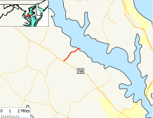
Route information Maintained by MDSHA Length: 2.58 mi[1] (4.15 km) Major junctions South end:  MD 235 in Oakville
North end: South Sandgates Road in Sandgates Location Counties: St. Mary's Highway system Maryland highway system
Interstate • US • State • Minor • Former • Turnpikes←  MD 471
MD 473  →
→Maryland Route 472 (MD 472) is a state highway in the U.S. state of Maryland. Known as North Sandgates Road, the state highway runs 2.58 miles (4.15 km) from MD 235 in Oakville north to Sandgates Creek in Sandgates. MD 472 was built in 1933.
Contents
Route description
MD 472 begins at an intersection with MD 235 (Three Notch Road) in Oakville. The state highway heads northeast as a two-lane road through farmland and forest with scattered residences. After passing the historic home Sandgates on Cat Creek, MD 472 enters the beach community of Sandgates on the Patuxent River. The state highway reaches its northern terminus at the west end of the county-maintained wooden-floored bridge over Sandgates Creek.[2] The roadway continues south as South Sandgates Road, a county highway that connects back with MD 235 in Hillville.[1][3]
History
MD 472 was constructed in 1933.[4][5] Aside from repaving, the state highway has changed very little since then.
Junction list
The entire route is in St. Mary's County.
Location Mile[1] Destinations Notes Oakville 0.00 MD 235 (Three Notch Road) – Waldorf, Lexington ParkSouthern terminus Sandgates 2.58 South Sandgates Road Northern terminus; state maintenance ends at west end of bridge over Sandgates Creek 1.000 mi = 1.609 km; 1.000 km = 0.621 mi References
- ^ a b c "Highway Location Reference: St. Mary's County" (PDF). Maryland State Highway Administration. 2009. http://www.marylandroads.com/Location/2009_SAINTMARYS.pdf. Retrieved 2010-12-16.
- ^ St. Mary's County Department of Public Works and Transportation (August 2009). "Bridge Inventory Update". http://www.stmarysmd.com/docs/BridgeInventory-8-09.pdf. Retrieved 2010-12-16.
- ^ Google, Inc. Google Maps – Maryland Route 472 (Map). Cartography by Google, Inc. http://maps.google.com/maps?f=d&source=s_d&saddr=oakville,+md&daddr=MD-472+E%2FN+Sandgates+Rd&hl=en&geocode=FcTNSQIdDINu-yljMmPdAHC3iTF3jnUh_6fxRw%3BFZsiSgIdkA5v-w&mra=ls&sll=38.413114,-76.608412&sspn=0.001929,0.004823&ie=UTF8&t=h&z=14. Retrieved 2010-12-16.
- ^ Maryland Geological Survey. Map of Maryland Showing State Road System: State Aid Roads and Improved County Road Connections (Map) (1933 ed.).
- ^ Report of the State Roads Commission of Maryland. 1931-1934. Baltimore: Maryland State Roads Commission. 1934-12-28. p. 352. http://www.archive.org/details/reportofstateroa1931mary. Retrieved 2010-12-16.
External links
Roads in St. Mary's County, Maryland State highways  Categories:
- State highways in Maryland
- Roads in St. Mary's County, Maryland


Wikimedia Foundation. 2010.