- Maryland Route 245
-
Maryland Route 245
Route information Maintained by MDSHA Length: 7.55 mi[1] (12.15 km) Major junctions South end: 

 MD 5 / MD 5 Bus. in Leonardtown
 MD 235 in Hollywood
North end: Steer Horn Neck Road near Hollywood Location Counties: St. Mary's Highway system Maryland highway system
Interstate • US • State • Minor • Former • Turnpikes←  MD 244
MD 246  →
→Maryland Route 245 (MD 245) is a state highway in the U.S. state of Maryland. Known for most of its length as Hollywood Road, the state highway runs 7.55 miles (12.15 km) from MD 5 and MD 5 Business in Leonardtown north to Steer Horn Neck Road near Hollywood. MD 245 connects Leonardtown with MD 235 in Hollywood in central St. Mary's County. The state highway was constructed in the mid 1920s and rebuilt around 1950.
Contents
Route description
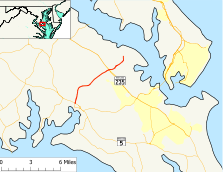
MD 245 begins at an intersection with MD 5 (Point Lookout Road) and MD 5 Business (Washington Street) in the town of Leonardtown. MD 5 Business heads south from the intersection opposite MD 245 to serve downtown Leonardtown. MD 245 heads north as Hollywood Road, a three-lane road with center turn lane. The state highway immediately passes between the Leonardtown campus of the College of Southern Maryland and the St. Mary's Nursing Center. MD 245 continues north past several county facilities, including the St. Mary's Hospital and the St. Mary's County Governmental Center. The state highway passes Leonard Hall Naval Academy and the T Barracks of the Maryland State Police before the road narrows to two lanes and leaves the town limits of Leonardtown.[1][2]
At McIntosh Road, MD 245 curves northeast through a mix of farmland and forest. The state highway crosses Brooks Run before Old Hollywood Road, a loop of old alignment, splits to the east next to Hollywood Park. MD 245 enters the community of Hollywood, where the state highway intersects MD 235 (Three Notch Road) and Old Three Notch Road, the old alignment of MD 235. MD 245 continues northeast as Sotterley Road. The state highway crosses a branch of Cuckold Creek before reaching its northern terminus at Steer Horn Neck Road, which heads east toward Greenwell State Park. Sotterley Road continues north as a county highway toward Sotterley Plantation on the shore of the Patuxent River.[1][2]
History
MD 245 was constructed as a gravel road from MD 5 in Leonardtown north to McIntosh Road around 1923.[3] The state highway was extended northeast to Hollywood in 1924 and 1925 and to its present northern terminus near Sotterley in 1925 and 1926.[4][5] MD 245 was reconstructed and widened as a bituminous stabilized gravel road from Leonardtown to St. Johns Road in 1948.[6] The state highway was rebuilt with a bituminous concrete surface from St. Johns Road to MD 235 in Hollywood in 1950 and 1951; this project included the relocation of the state highway around what is now Old Hollywood Road.[7]
Junction list
The entire route is in St. Mary's County.
Location Mile[1] Destinations Notes Leonardtown 0.00
MD 5 (Point Lookout Road) / MD 5 Bus. south (Washington Street) – Lexington Park, WaldorfSouthern terminus Hollywood 3.63 Old Hollywood Road north Old alignment of MD 245 4.33 Old Hollywood Road south 5.27 MD 235 (Three Notch Road) – Lexington Park, Waldorf7.55 Sotterley Road north / Steer Horn Neck Road east Northern terminus 1.000 mi = 1.609 km; 1.000 km = 0.621 mi References
- ^ a b c d "Highway Location Reference: St. Mary's County" (PDF). Maryland State Highway Administration. 2009. http://www.marylandroads.com/Location/2009_SAINTMARYS.pdf. Retrieved 2010-12-13.
- ^ a b Google, Inc. Google Maps – Maryland Route 245 (Map). Cartography by Google, Inc. http://maps.google.com/maps?f=d&source=s_d&saddr=Hollywood+Rd&daddr=MD-245+N%2FSotterley+Rd&geocode=FZ5dSAId_KNu-w%3BFYRsSQIdXgRw-w&hl=en&mra=ls&sll=38.357979,-76.54707&sspn=0.015446,0.038581&ie=UTF8&t=h&z=12. Retrieved 2010-12-13.
- ^ Maryland Geological Survey. Map of Maryland: Showing State Road System and State Aid Roads (Map) (1923 ed.).
- ^ Report of the State Roads Commission of Maryland. 1924-1926. Baltimore: Maryland State Roads Commission. January 1927. pp. 36, 65. http://www.archive.org/details/annualreportsofs1924mary. Retrieved 2010-12-13.
- ^ Maryland Geological Survey. Map of Maryland: Showing State Road System and State Aid Roads (Map) (1927 ed.).
- ^ Report of the State Roads Commission of Maryland. 1949-1950. Baltimore: Maryland State Roads Commission. 1950-12-20. p. 158. http://www.archive.org/details/reportofstateroa1949mary. Retrieved 2010-12-13.
- ^ Report of the State Roads Commission of Maryland. 1951-1952. Baltimore: Maryland State Roads Commission. 1952-12-15. p. 173. http://www.archive.org/details/reportofstateroa1951mary. Retrieved 2010-12-13.
External links
Roads in St. Mary's County, Maryland State highways  Categories:
- State highways in Maryland
- Roads in St. Mary's County, Maryland


Wikimedia Foundation. 2010.