- Maryland Route 489
-
Maryland Route 489
Park Hall Road 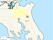
Route information Maintained by MDSHA Length: 1.27 mi[1] (2.04 km) Major junctions West end:  MD 5 in Park Hall
East end:  MD 235 in Park Hall
Location Counties: St. Mary's Highway system Maryland highway system
Interstate • US • State • Minor • Former • Turnpikes←  MD 488
MD 490  →
→Maryland Route 489 (MD 489) is a state highway in the U.S. state of Maryland. Known as Park Hall Road, the state highway runs 1.27 miles (2.04 km) from MD 5 east to MD 235 within Park Hall Estates in southern St. Mary's County. MD 489, which serves as a connector between MD 5 and MD 235 south of Lexington Park, was assigned to Park Hall Road in 1956.
Contents
Route description
MD 489 begins at an intersection with MD 5 (Point Lookout Road) in the unincorporated community of Park Hall Estates between St. Mary's City and Great Mills. The state highway heads east as a two-land road through a mix of farmland and forest. MD 489 reaches its eastern terminus at MD 235 (Three Notch Road) between Ridge and Hermanville.[1][2]
History
The MD 489 designation was originally applied to Whiteleysburg Road in Whiteleysburg in Caroline County.[3] MD 489 was removed from Whiteleysburg Road in 1950; the highway is now part of MD 314.[4][5] MD 489 was assigned to Park Hall Road in 1956.[6] Aside from repaving, the state highway has changed very little since then.
Junction list
The entire route is in Park Hall Estates in St. Mary's County.
Mile[1] Destinations Notes 0.00 MD 5 (Point Lookout Road) – St. Mary's City, LeonardtownWestern terminus 1.27 MD 235 (Three Notch Road) – Lexington Park, RidgeEastern terminus 1.000 mi = 1.609 km; 1.000 km = 0.621 mi References
- ^ a b c "Highway Location Reference: St. Mary's County" (PDF). Maryland State Highway Administration. 2009. http://www.marylandroads.com/Location/2009_SAINTMARYS.pdf. Retrieved 2010-12-14.
- ^ Google, Inc. Google Maps – Maryland Route 489 (Map). Cartography by Google, Inc. http://maps.google.com/maps?f=d&source=s_d&saddr=Park+Hall+Rd&daddr=Park+Hall+Rd&geocode=FfgsRwIdPMVx-w%3BFb4rRwIdMB1y-w&hl=en&mra=ls&sll=38.217009,-76.421242&sspn=0.015476,0.038581&ie=UTF8&ll=38.218324,-76.418753&spn=0.015476,0.038581&t=h&z=15. Retrieved 2010-12-14.
- ^ Maryland State Roads Commission. General Highway Map: State of Maryland (Map) (1939 ed.).
- ^ Maryland State Roads Commission. Maryland: Official Highway Map (Map) (1950 ed.).
- ^ "Highway Location Reference: Caroline County" (PDF). Maryland State Highway Administration. 2009. http://www.marylandroads.com/Location/2009_CAROLINE.pdf. Retrieved 2010-12-14.
- ^ Maryland State Roads Commission. Maryland: Official Highway Map (Map) (1956 ed.).
External links
Roads in St. Mary's County, Maryland State highways 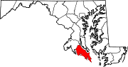 Categories:
- State highways in Maryland
- Roads in St. Mary's County, Maryland


Wikimedia Foundation. 2010.