- Maryland Route 225
-
Maryland Route 225
Hawthorne Road 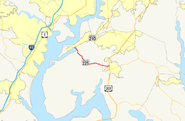
Map of Southern Maryland with MD 225 highlighted in redRoute information Maintained by MDSHA Length: 10.59 mi[1] (17.04 km) Major junctions West end:  MD 210 in Potomac Heights
 MD 224 in Mason Springs
East end:  US 301 in La Plata
Location Counties: Charles Highway system Maryland highway system
Interstate • US • State • Minor • Former • Turnpikes← MD 224MD 227  →
→Maryland Route 225 (MD 225) is a state highway in the U.S. state of Maryland. Known as Hawthorne Road, the state highway runs 10.59 miles (17.04 km) from MD 210 in Potomac Heights east to U.S. Route 301 (US 301) in La Plata. MD 225 connects La Plata, the county seat of Charles County, with Indian Head in the northwestern part of the county, which is home to Indian Head Naval Surface Warfare Center. The state highway was designated one of the original state roads by the Maryland State Roads Commission and constructed in the mid 1910s. MD 225 was reconstructed in the early 1950s, shortly after the highway's western terminus was moved to Potomac Heights following the completion of Indian Head Highway during World War II.
Contents
Route description
MD 225 begins at an intersection with MD 210 (Indian Head Highway) in Potomac Heights. The state highway heads south as a two-lane road, descending into the forested bottomlands of Mattawoman Creek, where the highway intersects the Indian Head Rail Trail and intersects MD 224 (Livingstone Road). The two highways join in a concurrency to cross the creek into the hamlet of Mason Springs, where MD 224 diverges to the west toward Marbury and MD 225 passes the historic home Araby. MD 225 heads southeast along the southern edge of Myrtle Grove Wildlife Management Area to the community of Ripley, where the highway curves east. At the hamlet of Marshalls Corner, the state highway intersects Marshall Corner Road, which heads north to Pomfret, and Rose Hill Road, which provides access to Thomas Stone National Historic Site. MD 225 passes the historic home Locust Grove before intersecting Valley Road and Mitchell Road at the corner of the Hawthorne Country Club. Valley Road heads north toward a trio of historic homes—Linden, Mount Carmel Monastery, and Thainston— and the La Plata campus of the College of Southern Maryland. MD 225 enters the town of La Plata, passing through a residential area before reaching its eastern terminus at US 301 (Robert Crain Highway). The roadway continues east as Hawthorne Drive, the old alignment of MD 225, east to Washington Avenue, the old alignment of US 301.[1][2]
History
The La Plata–Indian Head road was one of the original state roads marked for improvement by the Maryland State Roads Commission in 1909. A short section of pavement had already been laid as a state aid road in Potomac Heights by 1910.[3] The highway was constructed as a 14-foot (4.3 m) gravel road from Indian Head to Mason Springs in 1913 and from La Plata to Ripley in 1915.[4] The gap between Mason Springs and Ripley was filled by 1919.[5][6] In La Plata, the highway's eastern terminus was originally Washington Avenue, which was the original alignment of MD 3 and later US 301. MD 225 originally extended west along Strauss Avenue through Indian Head to the entrance to U.S. Naval Proving Ground.[7][8] The state highway was supplanted by Indian Head Highway as the main access to the military base when that highway was constructed from Washington to Indian Head during World War II.[9] MD 225 was relocated from Strauss Avenue to its present terminus western terminus in Potomac Heights in 1950.[10] The state highway was widened to a 24-foot (7.3 m) road with a bituminous-stabilized gravel surface from La Plata to Ripley in 1949 and 1950 and from Ripley to Potomac Heights in 1951.[11][12] MD 225 was resurfaced again in 1953 and 1954.[13] MD 225's eastern terminus was rolled back from Washington Avenue to US 301 around 1956.[14]
Junction list
The entire route is in Charles County.
Location Mile[1] Destinations Notes Potomac Heights 0.00 MD 210 (Indian Head Highway) – Indian Head, WashingtonWestern terminus Mason Springs 1.23 MD 224 north (Livingston Road) – PomonkeyWest end of concurrency with MD 224 1.63 MD 224 south (Chicamuxen Road) – MarburyEast end of concurrency with MD 224 La Plata 10.59 US 301 (Robert Crain Highway) / Hawthorne Drive east – Waldorf, RichmondEastern terminus 1.000 mi = 1.609 km; 1.000 km = 0.621 mi References
- ^ a b c "Highway Location Reference: Charles County" (PDF). Maryland State Highway Administration. 2009. http://www.marylandroads.com/Location/2009_CHARLES.pdf. Retrieved 2011-01-10.
- ^ Google, Inc. Google Maps – Maryland Route 225 (Map). Cartography by Google, Inc. http://maps.google.com/maps?f=d&source=s_d&saddr=Hawthorne+Rd&daddr=W+Hawthorne+Dr&hl=en&geocode=FUwFTQIdZAdn-w%3BFTIRTAId7E9p-w&mra=ls&sll=38.535847,-76.983433&sspn=0.0143,0.038581&ie=UTF8&ll=38.567227,-77.059135&spn=0.123212,0.308647&t=h&z=12. Retrieved 2011-01-10.
- ^ Maryland Geological Survey. Map of Maryland (Map) (1910 ed.).
- ^ Report of the State Roads Commission of Maryland. 1912-1915. Baltimore: Maryland State Roads Commission. May 1915. p. 110. http://www.archive.org/details/annualreportsofs1912mary. Retrieved 2011-01-10.
- ^ Report of the State Roads Commission of Maryland. 1916-1919. Baltimore: Maryland State Roads Commission. January 1920. p. 32. http://www.archive.org/details/annualreportsofs1916mary. Retrieved 2011-01-10.
- ^ Maryland Geological Survey. Map of Maryland: Showing State Road System and State Aid Roads (Map) (1921 ed.).
- ^ Maryland State Roads Commission. General Highway Map: State of Maryland (Map) (1939 ed.).
- ^ United States Geological Survey. Indian Head, MD quadrangle (Map). 1:48,000. 15 Minute Series (Topographic) (1925 ed.). http://historical.mytopo.com/quad.cfm?quadname=Indian%20Head&state=MD&series=15. Retrieved 2011-01-10.
- ^ Maryland State Roads Commission. Maryland: Official Highway Map (Map) (1946-47 ed.).
- ^ Maryland State Roads Commission. Maryland: Official Highway Map (Map) (1950 ed.).
- ^ Report of the State Roads Commission of Maryland. 1949-1950. Baltimore: Maryland State Roads Commission. 1950-12-20. pp. 152, 157. http://www.archive.org/details/reportofstateroa1949mary. Retrieved 2011-01-10.
- ^ Report of the State Roads Commission of Maryland. 1951-1952. Baltimore: Maryland State Roads Commission. 1952-12-15. p. 170. http://www.archive.org/details/reportofstateroa1951mary. Retrieved 2011-01-10.
- ^ Report of the State Roads Commission of Maryland. 1953-1954. Baltimore: Maryland State Roads Commission. 1954-11-12. pp. 189, 192. http://www.archive.org/details/reportofstateroa1953mary. Retrieved 2011-01-10.
- ^ Maryland State Roads Commission. Maryland: Official Highway Map (Map) (1956 ed.).
External links
Roads in Charles County, Maryland State highways 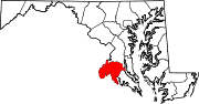
U.S. Highways Categories:- State highways in Maryland
- Roads in Charles County, Maryland


Wikimedia Foundation. 2010.