- Hampstead, Maryland
Infobox Settlement
official_name = Hampstead, Maryland
settlement_type =Town
nickname = H Town
motto =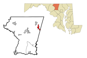
mapsize = 250x200px
map_caption = Location of Hampstead, Maryland
mapsize1 =
map_caption1 =subdivision_type = Country
subdivision_name =United States
subdivision_type1 = State
subdivision_name1 =Maryland
subdivision_type2 = Counties
subdivision_name2 = Carroll, Baltimore
government_footnotes =
government_type =
leader_title =
leader_name =
leader_title1 =
leader_name1 =
established_title =
established_date =unit_pref = Imperial
area_footnotes =area_magnitude =
area_total_km2 = 6.9
area_land_km2 = 6.9
area_water_km2 = 0.0
area_total_sq_mi = 2.7
area_land_sq_mi = 2.7
area_water_sq_mi = 0.0population_as_of = 2000
population_footnotes =
population_total = 5060
population_density_km2 = 728.6
population_density_sq_mi = 1887.1timezone = Eastern (EST)
utc_offset = -5
timezone_DST = EDT
utc_offset_DST = -4
elevation_footnotes =
elevation_m = 283
elevation_ft = 928
latd = 39 |latm = 36 |lats = 37 |latNS = N
longd = 76 |longm = 51 |longs = 5 |longEW = Wpostal_code_type =
ZIP code
postal_code = 21074
area_code = 410
blank_name = FIPS code
blank_info = 24-36500
blank1_name = GNIS feature ID
blank1_info = 0590408
website =
footnotes =Hampstead is a town in Carroll and Baltimore counties in the
U.S. state ofMaryland . The population was 5,060 at the 2000 census. It is currently the only community in Baltimore County to have a local government.Geography
Hampstead is located at coor dms|39|36|37|N|76|51|5|W|city (39.610303, -76.851493)GR|1.
According to the
United States Census Bureau , the town has a total area of 2.7square mile s (6.9km² ).None of the area is covered with water.Hampstead is approximately three miles south of Manchester, and 6 miles east of Westminster.
Demographics
As of the
census GR|2 of 2000, there were 5,060 people, 1,787 households, and 1,327 families residing in the town. Thepopulation density was 1,887.1 people per square mile (729.0/km²). There were 1,851 housing units at an average density of 690.3/sq mi (266.7/km²). The racial makeup of the town was 97.79% White, 0.79% African American, 0.06% Native American, 0.51% Asian, 0.06% from other races, and 0.79% from two or more races. Hispanic or Latino of any race were 1.09% of the population.There were 1,787 households out of which 50.7% had children under the age of 18 living with them, 59.3% were married couples living together, 11.4% had a female householder with no husband present, and 25.7% were non-families. 21.6% of all households were made up of individuals and 6.7% had someone living alone who was 65 years of age or older. The average household size was 2.83 and the average family size was 3.32.
In the town the population was spread out with 34.7% under the age of 18, 5.8% from 18 to 24, 39.5% from 25 to 44, 14.2% from 45 to 64, and 5.8% who were 65 years of age or older. The median age was 31 years. For every 100 females there were 94.3 males. For every 100 females age 18 and over, there were 88.0 males.
The median income for a household in the town was $56,655, and the median income for a family was $62,460. Males had a median income of $45,000 versus $30,407 for females. The
per capita income for the town was $22,730. About 1.3% of families and 2.4% of the population were below thepoverty line , including 1.5% of those under age 18 and 6.4% of those age 65 or over.Other Information
The main schools In Hampstead are
North Carroll High School , North Carroll Middle School, Shiloh Middle School, Spring Garden Elementary School and Hampstead Elementary School, which also service other towns and unincorporated areas nearby. It is a somewhat unknown fact that the headquarters ofJoS. A. Bank Clothiers is here.In the 2009 - 2010 school year, North Carroll High will be broken up to feed the newly constructed, Manchester Valley High School. This means that for the first time since it's establishment in the fifties, that North Carroll will feed mainly from Hampstead and not from neighboring Manchester.
History
*1631 -
King Charles I of England gives a portion of what is now known as Maryland to Lord Baltimore.
*1680 -Christopher Gist marks a trail from Patapsco (Baltimore ), to Le Tort (Carlisle, Pennsylvania ) passing through what was to become Hampstead.
*1720 - The trail evolves into a road.
*1786 - Christopher Baughan maps out the town. Early settlers are disappointed to find noiron ore which they had expected, and becamefarmer s instead.
*Late 1700s - The road through Hampstead is improved. Astagecoach line runs on it between Baltimore and Carlisle.
*1796 - Peter Frank turns the town's first building into atavern and overnightlodging for guests. This was especially lucrative because the town was "swampy" and many travelers would get "bogged down" in it.
*About 1800 - Firstone-room school house is built, where St. John's Methodist church stands today.
*1837 - Carroll County is carved out of parts of Baltimore and Frederick counties. Hampstead becomes the easternmost town in the newly formed county.
*1860 - Many Hampstead residents are involved in theAmerican Civil War in some capacity. Evidence of tunnels from this era, perhaps used to hide slaves or horses, exists in one of the houses on Main Street.
*1879 - The firstrailroad passes through town, running up to Gettysburg.
*1888 - The town is officially incorporated. It was about 6,500 feet long, north to south.
*1904 - The townjail , with one room, is built behind the old fire hall, which is now "Towne Pride Interiors".
*Early 1920s - Malco Milling and Lighting Company occupies a five-story building on Gill Avenue. It attempts to provide DC current electricity, with little success or reliability. This building is still the tallest building in town.
*1919 - The Hampstead School is finished and dedicated. It is the first consolidatedpublic school building in Hampstead.
*1923 - The main road is paved.
*1924 - The firstbus line runs passengers south to Emory Grove. Once there passengers could pick up a trolley to Baltimore.
*1925 - The same bus line is extended north toHanover, Pennsylvania .
*Late 1920s - TheBaltimore Gas & Electric Company runs a line through town.
*1935 - Water lines are run into the town.
*1953 - TheMayor andTown council establish offices in the old First National Bank building on South Main Street.
*1956 - North Carroll Senior High School is opened in Greenmount, consolidating Hampstead and Manchester High Schools.
*1962 - North Carroll Senior High School is enlarged and renamed North Carroll Junior-Senior High School.
*1975 - The currentNorth Carroll High School opens on Hampstead-Mexico Road to accommodate a rising population.
*1986 - A new Hampstead Elementary School opens near the new high school. The oldest building, built in 1919 and now serving solely elementary students, is closed.
*1991 - Spring Garden Elementary is opened to accommodate the need for another elementary school.
*1998 - The building which once housed The First National Bank of Hampstead is renovated to house the Hampstead Police Department.
*2000 - Shiloh Middle School is opened to accommodate the needs for the rising population in Hampstead.
*2006 - Ground is broken on the Hampstead Bypass which will attempt to reduce traffic in town as part of a larger plan to renovate and revitalize the town's Main Street."All timeline information is from Joan Prall's "Hampstead: Its Heart and History", published in 1998, or from any of the external links listed below."
External links
* [http://www.townofhampstead.us/ Town of Hampstead official website]
* [http://www.hampsteadtoday.com/ Hampstead Today - Hampstead, MD daily news headlines, weather, more.]
* [http://www.city-data.com/city/Hampstead-Maryland.html Statistical Data]

Wikimedia Foundation. 2010.