- Franklin, Virginia
-
Franklin, Virginia — City — 
SealLocation in the Commonwealth of Virginia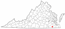
Coordinates: 36°40′29″N 76°55′50″W / 36.67472°N 76.93056°W Country United States State Virginia Incorporated March, 1876 Government - Mayor James P. Councill, III Area - City 8.4 sq mi (21.8 km2) - Land 8.4 sq mi (21.6 km2) - Water 0.1 sq mi (0.1 km2) Elevation 39 ft (12 m) Population (2010) - City 8,582 - Density 999.2/sq mi (385.9/km2) - Metro 1,645,015 Time zone EST (UTC-5) - Summer (DST) EDT (UTC-4) ZIP code 23851 Area code(s) 757 FIPS code 51-29600[1] GNIS feature ID 1494943[2] Website http://www.franklinva.com/ Franklin is an independent city in Virginia. The Bureau of Economic Analysis combines the city of Franklin with Southampton county for statistical purposes. The population was 8,582 in 2010.[3]
Contents
History
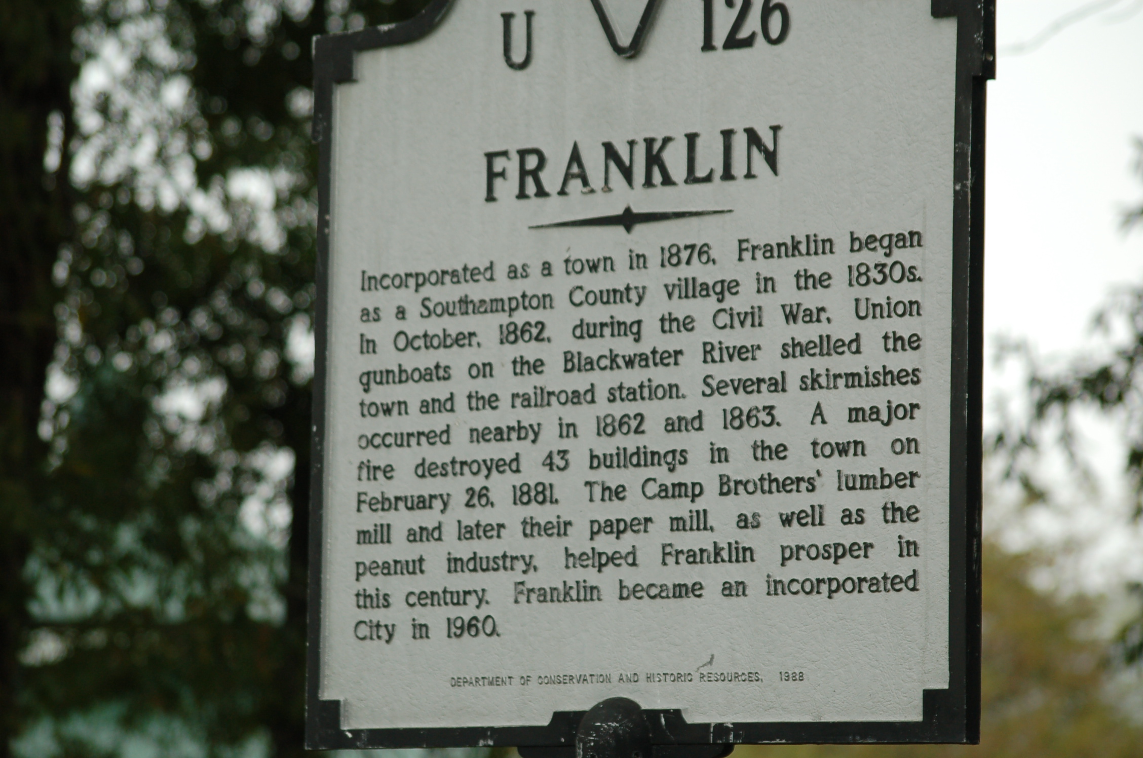
The city of Franklin had its humble beginnings in the 1830s as a railroad stop along the Blackwater River. During this era, the Blackwater River was used to transport goods to and from the Albemarle Sound in North Carolina.[4]
The Civil War
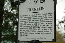
In 1862 the American Civil War came to Franklin, in what was referred to as the Joint Expedition Against Franklin[5] As several United States Navy Flag steamships, led by the USS Commodore Perry, tried to pass through Franklin on the Blackwater River, a band of local Confederates opened fire on the ships. As stated by an officer aboard one of the ships, "The fighting was the same—Here and there high banks with dense foliage, a narrow and very crooked stream, with frequent heavy firing of musketry."[6] In all, the battle yielded five naval casualites and 16 wounded. As the naval vessels retreated, the Confederates tried to block the narrow Blackwater River by felling large trees across the width. In the end, the Confederate attempts failed as no soldiers were captured and no ships were lost.[6] A total of 7 Medals of Honor were awarded to individual seamen for their distinguished service.[7][8]
Industrialization and the Camp family
It was not until 1887 that Franklin began to see significant growth. Six brothers from the Camp Family, with local roots, took possession of a local saw mill. The sawmill was small and had been operating for several years alongside the Blackwater River[9] With the Camp family's acquisition of the mill, it experienced 20 years of rapid growth under the leadership of Paul Douglas Camp(President), James Leonidas Camp(Vice-president) and Robert Judson Camp(Secretary-treasurer). At the end of this period, after bout with near bankruptcy, World War I brought the Camp Family back to financial success, bringing along with it the city of Franklin. By 1918, "Tiny Franklin had become a booming wartime village..."[9] By 1955, the Camp Corporation's annual sales reached $28 million, much of which they spread throughout the city of Franklin. The Camp family with a strong sense of family and community gave much back to the city of Franklin through above average wages and generous donations to local causes.[10] On May 29, 1956, the residents of Franklin were informed that the Local Camp Manufacturing Corporation had just negotiated a merger with the Union Bag and Paper company operating out of New York. This merger formed the Union Camp Corporation, locally known as Union Camp. Union Camp thrived in Franklin until 1999 when it was acquired by International Paper. Even though Union Camp no longer exists in Franklin, the Camp Family name lives on. Their legacy is most notable in the community, with the community college Paul D. Camp Community College, the James L Camp Jr. YMCA, the Texie Camp Marks Children's Center, and The Ruth Camp Campbell Memorial Library.
Economy
Modern day Franklin has two major industrial sectors which are agriculture and manufacturing.[11] Franklin is listed as being the 13th most profitable and 12th largest farming community in the state.[12] The neighboring communities Southampton County, Isle of Wight County and the City of Suffolk are all ranked in the top 20 most profitable farming counties, with Southampton County being the 8th largest in the state.[12] With the high agricultural profile of Franklin and the surrounding areas, it is no surprise that Agriculture is the primary industry for the city. It was not until the opening of the Camp Lumber Mill in 1887 that the manufacturing sector began to expand. The Camp Lumber Mill became the Union Camp Corporation which was eventually bought by International Paper.[11] Today, the International Paper Paper Mill located on the eastern boundary of the city, aside the Blackwater River, produces lumber, pulp and paper products and other chemical by-products.
International Paper announced on October 22, 2009 that the paper mill will be permanently closed in the spring of 2010. This occurred in May 2010.
Demographics
 Age distribution in Franklin
As of the census[1] of 2010, there were 8,582 people, 3,384 households, and 2,277 families residing in the city. The population density was 999.2 people per square mile (385.9/km²). There were 3,767 housing units at an average density of 451.0 per square mile (174.2/km²). The racial makeup of the city was 39.4% White, 56.9% Black or African American, 0.3% Native American, 0.7% Asian, 0.0% Pacific Islander, 0.7% from other races, and 1.9% from two or more races. 1.6% of the population were Hispanic or Latino of any race.
There were 3,384 households out of which 30.1% had children under the age of 18 living with them, 41.8% were married couples living together, 21.9% had a female householder with no husband present, and 32.7% were non-families. 28.9% of all households were made up of individuals and 12.8% had someone living alone who was 65 years of age or older. The average household size was 2.39 and the average family size was 2.93.
In the city the population was spread out with 25.1% under the age of 18, 7.7% from 18 to 24, 24.9% from 25 to 44, 23.9% from 45 to 64, and 18.4% who were 65 years of age or older. The median age was 40 years. For every 100 females there were 79.2 males. For every 100 females age 18 and over, there were 73.4 males.
The median income for a household in the city was $31,687, and the median income for a family was $40,299. Males had a median income of $32,083 versus $21,927 for females. The per capita income for the city was $18,573. About 16.8% of families and 19.8% of the population were below the poverty line, including 34.9% of those under age 18 and 10.2% of those age 65 or over.
Geography

Franklin is located at 36°40′29″N 76°55′50″W / 36.67472°N 76.93056°W (36.674954, -76.930799).[13] According to the United States Census Bureau, the city has a total area of 8.4 square miles (22 km2), of which, 8.4 square miles (22 km2) of it is land and 0.1 square miles (0.26 km2) of it (0.60%) is water.
Adjacent counties
Blackwater River
 22Ft. Water marker in downtown Franklin
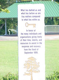 1999 Flood memorial
The Blackwater River, running along the eastern boundary of the city played an important role in the industrialization of the city, but has not been immune to problems plaguing rivers, most notably flooding. In 1999, in the aftermath of Hurricane Floyd, downtown Franklin was submerged under as much as 12 feet of water as the Blackwater River swelled to a new historical crest at 26.4 feet.[14] The hurricane flooding caused the submersion of 182 business and 150 homes located primarily in downtown.[15] In 2006, after a rain storm left the area saturated, the Blackwater River crested at close to 23 feet, the highest crest since 1940 excluding the flood in 1999[14]
Ironically, when the hurricane name "Floyd" was retired in 2000, the name chosen as a replacement was Franklin. In 2006, Franklin endured another large-scale flood reaching just below the record 23 foot water line set from the 1999 flood. The flood was the result of a storm which distributed a large amount of water throughout the watershed in which Franklin resides.
Community
Education
These are all places that provide education at some level in the area of Franklin.
- The Children's Center
- Rock Church School
- JP King Middle School
- SP Morton Elementary School
- SOUTHAMPTON ACADEMY Private School Courtland VA
- Franklin High School
- Southampton High School
- Southampton Academy - Grades Pre-K through 12th
- Paul D. Camp Community College
Community resources
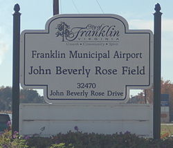
- Franklin Municipal Airport (John Beverly Rose Field)
- Ruth Camp Campbell Memorial Library
- James L. Camp Jr. YMCA
- Southampton Academy Courtland, VA
- Southampton Memorial Hospital
- The Tidewater News (www.tidewaternews.com)
See also
References
- ^ a b "American FactFinder". United States Census Bureau. http://factfinder.census.gov. Retrieved 2008-01-31.
- ^ "US Board on Geographic Names". United States Geological Survey. 2007-10-25. http://geonames.usgs.gov. Retrieved 2008-01-31.
- ^ [1]. Weldon Cooper Center 2010 Census Count Retrieved January 26, 2011
- ^ Rouse, Parke Jr. The Timber Tycoons - The Camp Families of Virginia and Florida, and their empire, 1887-1987. Southampton County Historical Society, 1988. . pg 1.
- ^ United States. US Navy. Report of the Secretary of the Navy, December, 1862. pg 149.
- ^ a b United States. US Navy. Report of the Secretary of the Navy, December, 1862. pg. 153
- ^ "Civil War Medal of Honor Recipients (M-Z)". United States Army Center of Military History. http://www.history.army.mil/html/moh/civwarmz.html. Retrieved 2006-11-07.
- ^ "Medal of Honor Recipients Civil War A-L". United States Army Center of Military History. http://www.history.army.mil/html/moh/civwaral.html. Retrieved 2006-11-07.
- ^ a b Rouse, Parke Jr. The Timber Tycoons - The Camp Families of Virginia and Florida, and their empire, 1887-1987. Southampton County Historical Society, 1988. . pg 2.
- ^ Rouse, Parke Jr. The Timber Tycoons - The Camp Families of Virginia and Florida, and their empire, 1887-1987. Southampton County Historical Society, 1988. . pg 3.
- ^ a b "Tourism & History". Archived from the original on 2006-10-29. http://web.archive.org/web/20061029195337/http://www.franklinva.com/tour_history.html. Retrieved 2006-11-07.
- ^ a b "Virginia Farm Bureau". Archived from the original on 2007-09-05. http://web.archive.org/web/20070905084033/http://www.nass.usda.gov/va/vpage2.htm. Retrieved 2008-01-22.
- ^ "US Gazetteer files: 2010, 2000, and 1990". United States Census Bureau. 2011-02-12. http://www.census.gov/geo/www/gazetteer/gazette.html. Retrieved 2011-04-23.
- ^ a b "Historic Crests for the Blackwater River near Franklin". http://newweb.erh.noaa.gov/ahps2/crests.php?wfo=akq&gage=fknv2. Retrieved 2006-11-07.
- ^ "Virginia Hurricane History". http://www.hpc.ncep.noaa.gov/research/roth/vahur.htm. Retrieved 2006-11-07.
External links
- City of Franklin
- Hampton Roads Economic Development Alliance - serving Franklin
Coordinates: 36°40′30″N 76°55′51″W / 36.674954°N 76.930799°W

Southampton County Southampton County 
Isle of Wight County  Franklin, Virginia

Southampton County Hampton Roads Major Cities Chesapeake · Hampton · Newport News · Norfolk · Portsmouth · Suffolk · Virginia Beach
Counties Currituck · Gloucester · Isle of Wight · James City · Mathews · Surry · York
Other cities Franklin · Poquoson · Williamsburg
Towns Claremont · Dendron · Smithfield · Surry · Windsor
Sub-regions Topics Transportation · People · History · Battle of Hampton Roads ·
Note: Italic indicates independent city not part of any countyCategories:- Cities in Virginia
- Franklin, Virginia
- Populated places in Virginia with African American majority populations
- Hampton Roads


Wikimedia Foundation. 2010.