- Charlottesville metropolitan area
-
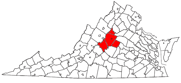
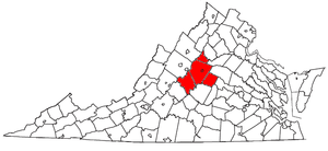 Location of the Charlottesville Metropolitan Statistical Area in Virginia
The Charlottesville Metropolitan Statistical Area is a Metropolitan Statistical Area (MSA) in Virginia as defined by the United States Office of Management and Budget (OMB). As of 2009, the Charlottesville MSA had a population of 195,847 [1].
Contents
MSA components
Note: Since a state constitutional change in 1871, all cities in Virginia are independent cities that are not located in any county. The OMB considers these independent cities to be county-equivalents for the purpose of defining MSAs in Virginia.
Four counties and one independent city are included in the Charlottesville Metropolitan Statistical Area.[2]
- Independent Cities
Communities
Places with more than 40,000 inhabitants
- Charlottesville (Principal city)
Places with 1,000 to 10,000 inhabitants
- Crozet (census-designated place)
- Lake Monticello (census-designated place)
Places with less than 1,000 inhabitants
- Columbia (incorporated town in Fluvanna County)
- Scottsville (incorporated town in Albemarle County)
- Stanardsville (incorporated town in Greene County)
Unincorporated places
- Adial
- Afton
- Allens Creek
- Amicus
- Arrington
- Avon
- Barboursville (partial)
- Barnes
- Beech Grove
- Bryant
- Buffalo Springs
- Burtonville
- Caskie
- Colleen
- Dawsonville
- Durrett Town
- Dyke
- Earlysville
- Elma
- Faber
Demographics
As of the census[3] of 2000, there were 174,021 people, 67,575 households, and 42,840 families residing within the MSA. The racial makeup of the MSA was 80.77% White, 14.07% African American, 0.16% Native American, 2.68% Asian, 0.03% Pacific Islander, 0.80% from other races, and 1.50% from two or more races. Hispanic or Latino of any race were 2.23% of the population.
The median income for a household in the MSA was $42,166, and the median income for a family was $50,225. Males had a median income of $32,974 versus $26,579 for females. The per capita income for the MSA was $21,574.
Politics
The Charlottesville area leans towards the Democratic party. Like many college towns, the city of Charlottesville is a Democratic stronghold, while the rural areas outside of Charlottesville and Ablemarle County are more conservative.
The Charlottesville area is located in Virginia's 5th congressional district, represented by Robert Hurt. The district has a Cook PVI of R+5. The previous representative, Tom Perriello, is a resident of the town of Ivy, located in Ablemarle county just west of Charlottesville.
Presidential election results Year GOP DEM Others 2008 39.6% 39,701 59.2% 59,247 1.2% 1.208 2004 47.4% 39,928 51.5% 43,374 1.2% 909 2000 48.7% 33,575 45.7% 32,129 6.4% 4,524 1996 45.0% 27,115 48.0% 28,903 6.9% 4,178 1992 41.4% 25,834 45.9% 28,644 12.7% 7,979 1988 54.6% 28,117 44.2% 22,767 1.3% 653 1984 59.3% 28,642 40.2% 19.142 0.5% 247 1980 48.2% 21,504 42.4% 18,918 9.6% 4,213 1976 49.9% 19,664 48.9% 18,892 2.2% 872 1972 61.6% 19,222 36.7% 11,452 1.8% 551 1968 48.4% 13.012 30.0% 8,030 21.7% 5,841 1964 46.6% 10,023 52.9% 11,370 0.5% 98 1960 54.1% 8,897 45.0% 7,404 0.9% 149 See also
References
- ^ [1]. Weldon Cooper Official Population Estimates Retrieved January 28, 2011
- ^ "Metropolitan Statistical Areas and Components" (TXT). Metropolitan statistical areas and metropolitan divisions defined by the Office of Management and Budget, November 2007. United States Census Bureau, Population Division. 2008-06-24. http://www.census.gov/population/www/metroareas/lists/2007/List4.txt. Retrieved 2008-09-01.
- ^ "American FactFinder". United States Census Bureau. http://factfinder.census.gov. Retrieved 2008-01-31.
Wikimedia Foundation. 2010.