- Portsmouth, Virginia
-
Portsmouth, Virginia Downtown Portsmouth
Nickname(s): P-town Location in the Commonwealth of Virginia
Coordinates: 36°49′52″N 76°20′44″W / 36.83111°N 76.34556°W Country United States State Virginia County None (independent city) Founded 1752 Government - Mayor Kenneth I. Wright Area - Total 46.6 sq mi (120.7 km2) - Land 33.2 sq mi (85.9 km2) - Water 13.5 sq mi (34.9 km2) Elevation 20 ft (6 m) Population (2010 Census) - Total 95,535 - Density 3,029.4/sq mi (1,170.9/km2) Time zone EST (UTC-5) - Summer (DST) EDT (UTC-4) Area code(s) 757 FIPS code 51-64000[1] GNIS feature ID 1497102[2] Website http://www.portsmouthva.gov/ Portsmouth is located in the Hampton Roads metropolitan areas of the U.S. Commonwealth of Virginia. As of 2010, the city had a total population of 95,535.[3]
The Norfolk Naval Shipyard, often called the Norfolk Navy Yard, is a historic and active U.S. Navy facility that is actually located in Portsmouth rather than Norfolk; the name "Norfolk" was adopted to avoid confusion with Portsmouth, New Hampshire, where a naval shipyard already existed when the Virginia facility opened. The shipyard builds, remodels, and repairs the Navy's ships of all types.
Directly opposite Norfolk, the city of Portsmouth also has miles of waterfront land on the Elizabeth River as part of the harbor of Hampton Roads. There is a ferry boat that takes riders back and forth across the water between Downtown Norfolk and Olde Towne Portsmouth.
Contents
History
Portsmouth is located on the western side of the Elizabeth River directly across from the City of Norfolk. In 1620, the future site of Portsmouth was recognized as suitable shipbuilding location by John Wood, a shipbuilder, who petitioned King James I of England for a land grant. The surrounding area was soon settled as a plantation community.[4]
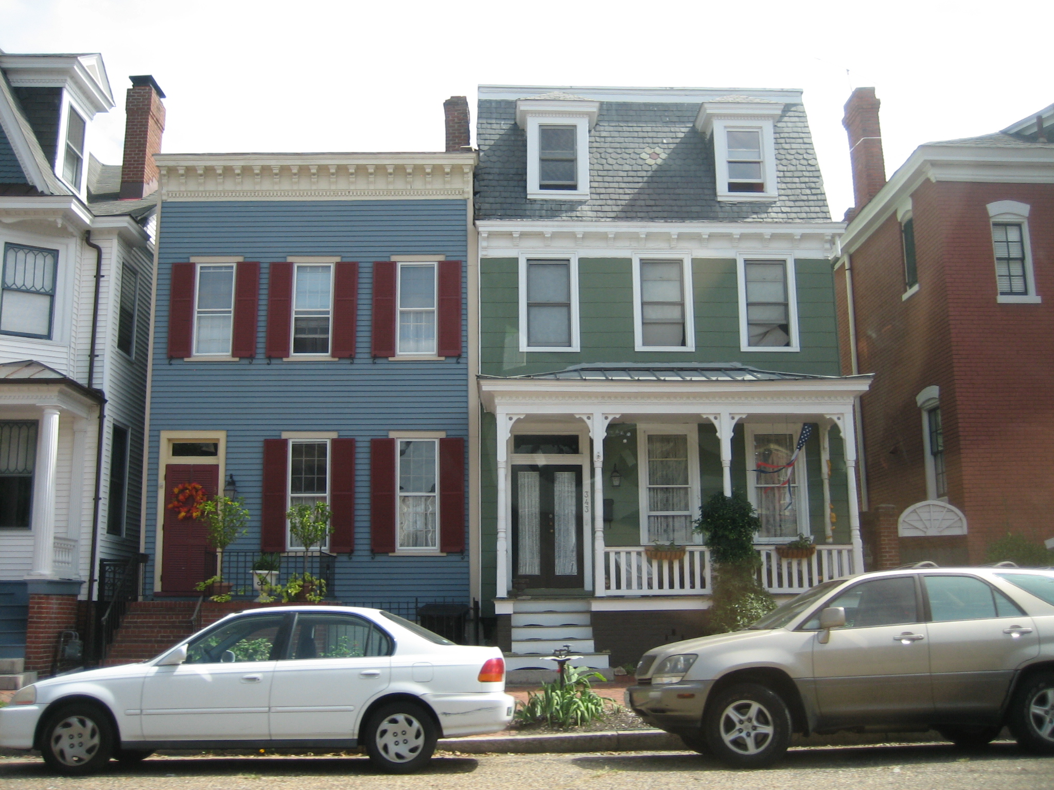
 Historic homes in Olde Towne Portsmouth
 Historic commercial building in Olde Towne
Portsmouth was founded as a town by an act of the Virginia General Assembly on behalf of 1752 by Col. William Crawford, a wealthy merchant and ship owner, who dedicated the four corners of High and Court Streets for a church, a market, a courthouse, and a jail. It was named for Portsmouth, England.[4]
In 1855, the Portsmouth and Norfolk area suffered an epidemic of yellow fever which killed 1 of every 3 citizens. It became an independent city from Norfolk County in 1858.
In 1767, Andrew Sprowle, a shipbuilder, founded the Gosport Shipyard adjacent to Portsmouth. The Gosport Shipyard at Portsmouth was owned by the Commonwealth of Virginia after the American Revolutionary War and was sold to the new United States federal government. During the American Civil War, in 1861, Virginia joined the Confederate States of America. Fearing that the Confederacy would take control of the shipyard at Portsmouth, the shipyard commander ordered the burning of the shipyard. The Confederate forces did in fact take over the shipyard, and did so without armed conflict through an elaborate ruse orchestrated by civilian railroad builder William Mahone (soon to become a famous Confederate officer). The Union forces withdrew to Fort Monroe across Hampton Roads, which was the only land in the area which remained under Union control.
In early 1862, the Confederate ironclad warship CSS Virginia was rebuilt using the burned-out hulk of USS Merrimack. Virginia engaged the Union ironclad USS Monitor in the famous Battle of Hampton Roads during the Union blockade of Hampton Roads. The Confederates burned the shipyard again when they left in May 1862.
Following the recapture of Norfolk and Portsmouth by the Union forces, the name of the shipyard was changed to Norfolk Naval Shipyard. The name of the shipyard was derived from its location in Norfolk County. The Norfolk Naval Shipyard today is located entirely within the city limits of Portsmouth, Virginia. The Norfolk Naval Shipyard name has been retained to minimize any confusion with the Portsmouth Naval Shipyard, which itself is actually located in Kittery, Maine across the Piscataqua River from Portsmouth, New Hampshire.

Portsmouth was the county seat of Norfolk County until 1963 when the new City of Chesapeake was formed in a political consolidation with the City of South Norfolk. Portsmouth's other county neighbor, the former Nansemond County, also consolidated with a smaller city, forming the new City of Suffolk in 1974.
One of the older cities of Hampton Roads, in the early 21st century, Portsmouth was undergoing moderate urban renewal in the downtown area. However, population had been declining and there was no room for expansion, as it is surrounded by water and other cities of South Hampton Roads.
The city has a radically limited tax base.[citation needed] A large portion of the city is controlled by the U.S. Navy; when Navy facilities are combined with schools, churches, and other tax-exempt entities, over half of Portsmouth's assessed valuation is off the tax rolls. The APM "MAERSK" marine terminal for container ships opened in 2007 in the West Norfolk section. Virginia has funded millions of dollars in railroad and transportation improvements to serve it.
Historic sites
The Olde Towne section features one of the largest collections of historically significant homes between Alexandria, Virginia and Charleston, South Carolina.[5] Located in Olde Towne is Emanuel African Methodist Episcopal Church (AME), which was built by slaves and free men and is the second-oldest building in Portsmouth and the city's oldest black church.
The city contains a number of historic buildings including the Pass House which was built in 1841 by Judge James Murdaugh and occupied by Union troops from 1862 to 1865. Federal forces required Portsmouth residents to obtain a written pass to travel across the Elizabeth River and beyond. These passes were issued from the English basement and thus the name "Pass House" was derived.
The Hill House
Four-story 1825 English basement home furnished entirely with original family belongings. It is evident from the furnishings that the Hill family were avid collectors and lived graciously over a period of 150 years. The house remains in its original condition, with limited renovation through the years.
Cedar Grove Cemetery
Established in 1832, Cedar Grove is the oldest city-owned cemetery in Portsmouth. Listed on the Virginia and national registers of historic sites, the cemetery is noted for its funerary art and the civic, business, maritime, religious and military leaders who are buried there. Historical markers placed throughout the cemetery allow for self-guided tours. The cemetery is located between Effingham Street and Fort Lane in Olde Towne Portsmouth. Entrance is through the south gate to the cemetery, located on London Boulevard.
Geography
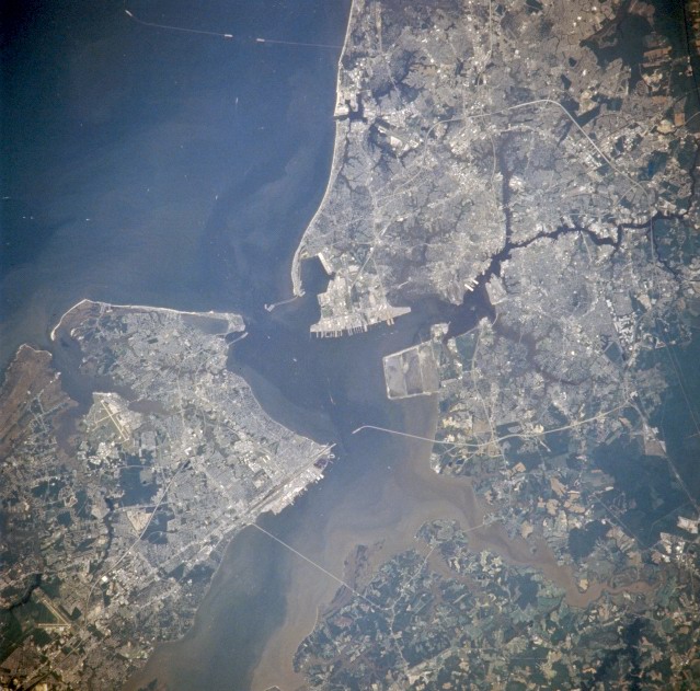
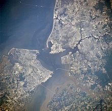 Newport News, Hampton, Portsmouth and Norfolk, Virginia from space in July 1996. (Portsmouth is in the center right portion of the photo)
Portsmouth is located at 36°49′52″N 76°20′44″W / 36.83111°N 76.34556°W (36.831298, -76.345641)[6].
According to the United States Census Bureau, the city has a total area of 46.6 square miles (121 km2), of which, 33.2 square miles (86 km2) of it is land and 13.5 square miles (35 km2) of it (28.87%) is water.
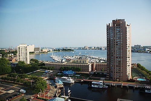
Cityscape
Portsmouth has a long history as a port town and city. The Olde Towne Business and Historical District is located in the downtown area, where a combination of preservation and redevelopment has been underway. An example is Hawthorn Hotel & Suites at The Governor Dinwiddie Hotel, which was renovated and reopened in 2005 after being closed for more than 10 years. It has been recognized by Historic Hotels of America, a program of the National Trust for Historical Preservation that identifies hotels that have maintained their historical integrity, architecture and ambiance and provides resources for their preservation.[7] The historic hotel was named for Governor Robert Dinwiddie, who was the administrative head of the Colony of Virginia during the time Portsmouth was founded in 1752. It was largely through his efforts that Virginia survived the French and Indian War relatively well.[8] (Dinwiddie County near Petersburg was also named for him).
High schools
There are three public high schools in Portsmouth, Virginia, located at three corners of the city. In the northwest section of the city, off Cedar Lane, is Churchland High School. In the downtown section of the city, off London Blvd/High Street, is I.C. Norcom High School. In the southwest section of Portsmouth, on Elmhurst Avenue, is Woodrow Wilson High School.
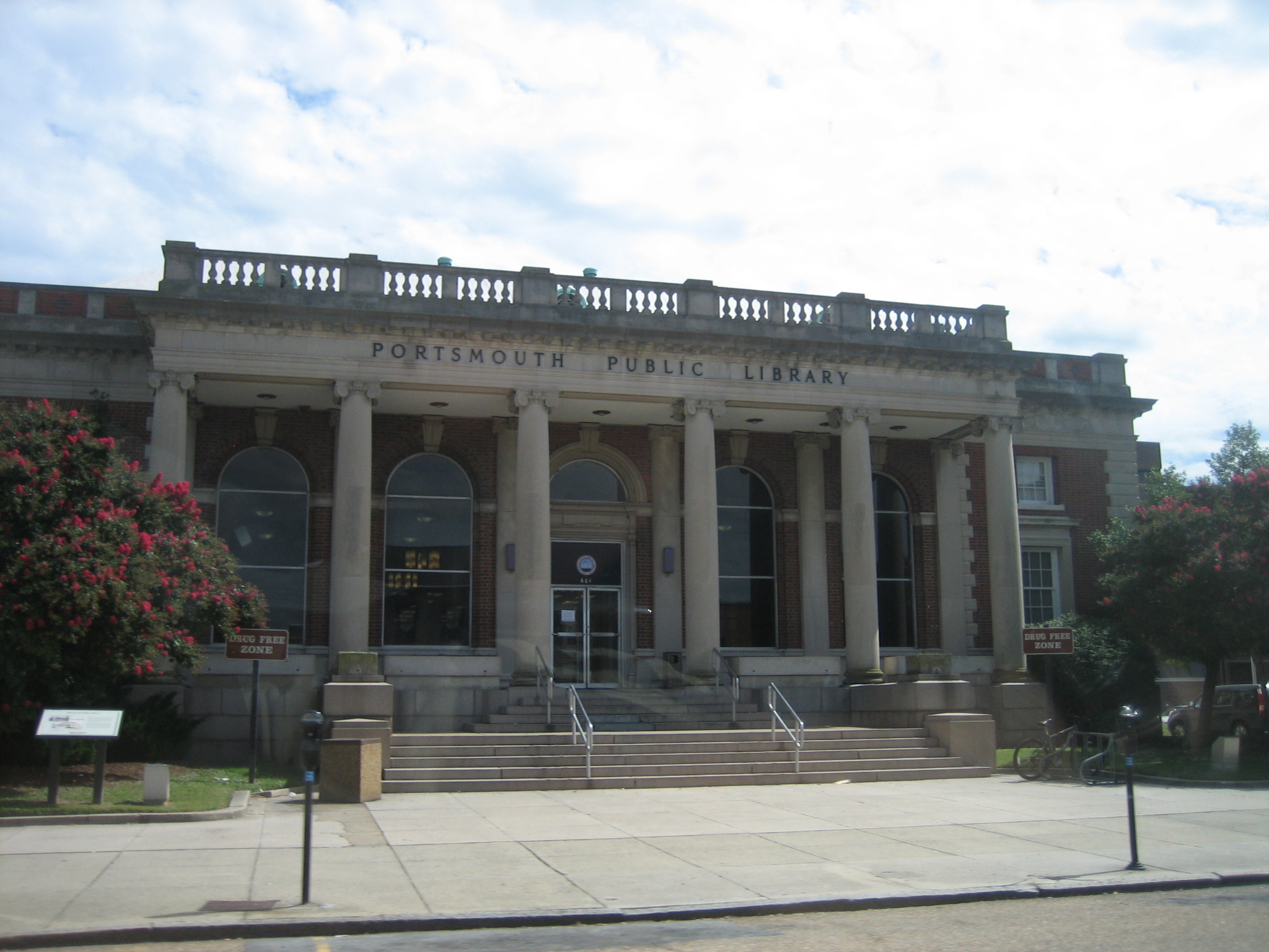
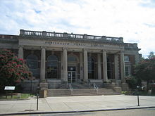 Portsmouth Library in Olde Towne
Climate
Portsmouth's mild humid subtropical climate means outdoor activities can be enjoyed year round. The weather in Portsmouth is temperate and seasonal. Summers are hot and humid with warm evenings. The mean annual temperature is 65 °F (18 °C), with an average annual snowfall of 3 inches and an average annual rainfall of 47 inches. No measurable snow fell in 1999. The wettest seasons are the spring and summer, although rainfall is fairly constant all year round. The highest recorded temperature was 105.0°F in 1980. The lowest recorded temperature was -3.0°F on January 21, 1985.[9][10]
Additionally, the geographic location of the city, with respect to the principal storm tracks, is especially favorable, as it is south of the average path of storms originating in the higher latitudes, and north of the usual tracks of hurricanes and other major tropical storms.[11] Snow falls rarely, averaging 3 inches (76 mm) per season.[12]
Climate data for Portsmouth, Virginia Month Jan Feb Mar Apr May Jun Jul Aug Sep Oct Nov Dec Year Record high °F 84 82 92 97 100 102 104 105 100 95 86 80 105 Average high °F 54 58 64 69 75 83 87 85 79 69 61 60 70.3 Average low °F 35 37 40 50 58 66 71 70 65 53 44 36 52.1 Record low °F −3 2 14 23 36 45 54 49 40 27 17 5 −3 Precipitation inches 3.93 3.34 4.08 3.38 3.74 3.77 5.17 4.79 4.06 3.47 2.98 3.03 45.74 Record high °C 29 28 33 36 38 39 40 41 38 35 30 27 41 Average high °C 12 14 18 21 24 28 31 29 26 21 16 16 21.3 Average low °C 2 3 4 10 14 19 22 21 18 12 7 2 11.2 Record low °C −19 −17 −10 −5 2 7 12 9 4 −3 −8 −15 −19 Precipitation mm 99.8 84.8 103.6 85.9 95 95.8 131.3 121.7 103.1 88.1 75.7 77 1,161.8 Source: The Weather Channel[13] Transportation
From the earliest development, Portsmouth has been oriented to the water. In the 1830s, it was the first community in Hampton Roads to receive a new land transportation innovation, railroad service. The Portsmouth and Roanoke Railroad, a predecessor of the Seaboard Air Line Railroad, extended to the rapids of the Roanoke River on its fall line near Weldon, North Carolina. It was to be 20 more years before its bigger neighbor, the City of Norfolk, also received a rail line, in 1858, when the Norfolk and Petersburg Railroad was completed.
Portsmouth is primarily served by the Norfolk International Airport (IATA: ORF, ICAO: KORF, FAA LID: ORF), now the region's major commercial airport. The airport is located near Chesapeake Bay, along the city limits of neighboring Norfolk and Virginia Beach.[14] Seven airlines provide nonstop services to twenty five destinations. ORF had 3,703,664 passengers take off or land at its facility and 68,778,934 pounds of cargo were processed through its facilities.[15] Newport News/Williamsburg International Airport (IATA: PHF, ICAO: KPHF, FAA LID: PHF) also provides commercial air service for the Hampton Roads area.[16] The Chesapeake Regional Airport provides general aviation services and is located five miles (8 km) outside the city limits.[17]
In the 21st century, the city has access to lines of CSX Transportation, Norfolk Southern and three short line railroads. Portsmouth is served by Interstate 264 and Interstate 664, which is part of the Hampton Roads Beltway. U.S. Route 17 and U.S. Route 58 pass through. The Elizabeth River is crossed via the Midtown Tunnel, the Downtown Tunnel and Berkley Bridge combination.
Transportation within the city, as well as the other cities of Hampton Roads, is served by a regional bus service, Hampton Roads Transit.[18]
Demographics
Historical populations Census Pop. %± 1840 6,477 — 1850 8,626 33.2% 1860 9,496 10.1% 1870 10,590 11.5% 1880 11,390 7.6% 1890 13,268 16.5% 1900 17,427 31.3% 1910 33,190 90.5% 1920 54,387 63.9% 1930 45,704 −16.0% 1940 50,745 11.0% 1950 80,039 57.7% 1960 114,773 43.4% 1970 110,963 −3.3% 1980 104,577 −5.8% 1990 103,910 −0.6% 2000 100,565 −3.2% 2010 95,535 −5.0%  Age distribution in Portsmouth
As of the census[1] of 2010, there were 95,535 people, 38,170 households, and 25,497 families residing in the city. The population density was 3,032.7 people per square mile (1,170.9/km²). There were 41,605 housing units at an average density of 1,254.7 per square mile (484.4/km²). The racial makeup of the city was 53.3% African American, 41.6% White, 0.4% Native American, 1.1% Asian, 0.1% Pacific Islander, 1.0% from other races, and 2.6% from two or more races. Hispanic or Latino of any race were 3.1% of the population.
There were 38,170 households out of which 30.6% had children under the age of 18 living with them, 41.1% were married couples living together, 10.9% have a female household with no husband present and 33.2% were non-families. 27.5% of all households were made up of individuals and 10.8% had someone living alone who was 65 years of age or older. The average household size was 2.51 and the average family size was 3.05.
In the city the population was spread out with 25.7% under the age of 18, 11.1% from 18 to 24, 29.1% from 25 to 44, 20.3% from 45 to 64, and 13.8% who were 65 years of age or older. The median age was 34 years. For every 100 females there were 93.5 males. For every 100 females age 18 and over, there were 90.6 males.
The median income for a household in the city was $36,742. Males had a median income of $30,122 versus $23,375 for females. The per capita income for the city was $16,507. About 13.3% of families and 16.2% of the population were below the poverty line, including 22.7% of those under age 18 and 10.7% of those age 65 or over.
Media
Portsmouth's daily newspaper is the Virginian-Pilot with The Currents being the Portsmouth edition of the Sunday paper. Other papers include the New Journal and Guide, and the Hampton Roads Business Journal.[19] Hampton Roads Magazine serves as a bi-monthly regional magazine for Portsmouth and the Hampton Roads area.[20] Portsmouth is served by a variety of radio stations on the AM and FM dials, with towers located around the Hampton Roads area.[21]
Portsmouth is also served by several television stations. The Hampton Roads designated market area (DMA) is the 42nd largest in the U.S. with 712,790 homes (0.64% of the total U.S.).[22] The major network television affiliates are WTKR-TV 3 (CBS), WAVY 10 (NBC), WVEC-TV 13 (ABC), WGNT 27 (CW), WTVZ 33 (MyNetworkTV), WVBT 43 (Fox), and WPXV 49 (ION Television). The Public Broadcasting Service station is WHRO-TV 15. Portsmouth residents also can receive independent stations, such as WSKY broadcasting on channel 4 from the Outer Banks of North Carolina and WGBS broadcasting on channel 7 from Hampton. Portsmouth is served by Cox Cable. DirecTV and Dish Network are also popular as an alternative to cable television in Portsmouth. WAVY-TV and WVBT-TV are both sister stations owned by LIN TV and have their office and studio located in the city.
See also
Sister cities
 Portsmouth, United Kingdom
 Dunedin, New Zealand
 Orizaba, Mexico
 Eldoret, Kenya
 Goree Island, Senegal
Notable residents
Notable current and former residents of Portsmouth include:
- Ruth Brown (1928–2006), R&B singer and actress.[23]
- Jack Temple Kirby (1938–2009), historian of the Southern United States, who was awarded the Bancroft Prize for his 2006 book Mockingbird Song: Ecological Landscapes of the South.[24]
- James Murphy (1967-) Metal guitarist. Such notable bands include Death, Testament, Obituary and Disincarnate.
- Missy Elliott (1971-) American recording artist, award winning producer, singer-songwriter, dancer, actress and clothing line designer.
- Wanda Sykes (1964-) Writer, stand-up comedian, and actress.
- Perry Ellis (1940–1986) American Fashion Designer who founded a sportswear house in the mid-1970s
References
- ^ a b "American FactFinder". United States Census Bureau. http://factfinder.census.gov. Retrieved 2008-01-31.
- ^ "US Board on Geographic Names". United States Geological Survey. 2007-10-25. http://geonames.usgs.gov. Retrieved 2008-01-31.
- ^ [1]. Weldon Cooper Center 2010 Census Count Retrieved January 26, 2011
- ^ a b City of Portsmouth, Virginia - History
- ^ Portsmouth Virginia, Department of Economic Development
- ^ "US Gazetteer files: 2010, 2000, and 1990". United States Census Bureau. 2011-02-12. http://www.census.gov/geo/www/gazetteer/gazette.html. Retrieved 2011-04-23.
- ^ Topic Galleries - dailypress.com
- ^ Robert Dinwiddie - Ohio History Central - A product of the Ohio Historical Society
- ^ Climate information from NOAA.
- ^ Maximum and minimum temperatures from Yahoo! Weather
- ^ Information from NOAA.
- ^ "Quick Data View Norfolk." National Oceanic and Atmospheric Administration. 1971-2000.
- ^ "Seasonal Temperature and Precipitation Information". http://www.weather.com/weather/wxclimatology/monthly/graph/USVA0557.
- ^ "Norfolk International Airport Mission and History". Norfolk International Airport. http://www.norfolkairport.com/airportinfo/missionhistory.htm. Retrieved 2007-10-02.
- ^ "Norfolk International Airport Statistics" (PDF). Norfolk International Airport. http://www.norfolkairport.com/airportinfo/orfstats.pdf. Retrieved 2007-10-02.
- ^ "Newport News/Williamsburg International Airport". Newport News/Williamsburg International Airport. http://www.nnwairport.com/. Retrieved 2008-02-25.
- ^ "Chesapeake Regional Airport". http://www.chesapeakeairport.com/. Retrieved 2008-01-12.
- ^ Hampton Roads Transit
- ^ "Hampton Roads News Links". abyznewslinks.com. http://www.abyznewslinks.com/unitevavb.htm. Retrieved 2007-08-06.
- ^ "Hampton Roads Magazine". Hampton Roads Magazine. http://www.hrmag.com. Retrieved 2007-08-06.
- ^ "Hampton Roads Radio Links". ontheradio.net. http://www.ontheradio.net/metro/Norfolk_VA.aspx. Retrieved 2007-08-06.
- ^ Holmes, Gary. "Nielsen Reports 1.1% increase in U.S. Television Households for the 2006-2007 Season." Nielsen Media Research. September 23, 2006. Retrieved on September 28, 2007.
- ^ Gulla, Bob (2008). Icons of R&B and Soul, p. 72. Greenwood Publishing Group.
- ^ Hevesi, Dennis. "Jack T. Kirby, Southern Historian, Dies at 70", The New York Times, August 13, 2009. Accessed August 14, 2009.
External links
- City of Portsmouth official website
- City of Portsmouth Events website
- Children's Museum of Virginia website
- Courthouse Galleries Museum website
- The Virginia Sports Hall of Fame & Museum website
- Portsmouth Virginia Guide
- Hampton Roads Economic Development Alliance - serving Portsmouth
Coordinates: 36°49′53″N 76°20′44″W / 36.831298°N 76.345641°W

Chesapeake Bay City of Suffolk 
City of Norfolk  Portsmouth, Virginia

City of Chesapeake City of Chesapeake City of Chesapeake Hampton Roads Major Cities Chesapeake · Hampton · Newport News · Norfolk · Portsmouth · Suffolk · Virginia Beach
Counties Currituck · Gloucester · Isle of Wight · James City · Mathews · Surry · York
Other cities Towns Claremont · Dendron · Smithfield · Surry · Windsor
Sub-regions Topics Transportation · People · History · Battle of Hampton Roads ·
Note: Italic indicates independent city not part of any countyCategories:- Cities in Virginia
- Portsmouth, Virginia
- Populated places in Virginia with African American majority populations
- Hampton Roads


Wikimedia Foundation. 2010.