- Orange County, Virginia
-
For other uses, see Orange County (disambiguation).
Orange County, Virginia 
Seal
Location in the state of Virginia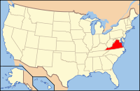
Virginia's location in the U.S.Founded 1734 Seat Orange Area
- Total
- Land
- Water
343 sq mi (888 km²)
342 sq mi (886 km²)
2 sq mi (5 km²), 0.50%Population
- Density
33,481
76/sq mi (29.2/km²)Website www.orangecova.com Orange County is a county located in the Commonwealth of Virginia. As of 2010, the population was 33,420.[1] Its county seat is Orange.[2]
Contents
History
The area was inhabited for thousands of years by varying cultures of indigenous peoples. At the time of European encounter, the historic Siouan-speaking Manahoac tribe lived in this Piedmont area.
The first European settlement in what was to become Orange County was Germanna, formed when Governor Alexander Spotswood settled 12 immigrant families from Westphalia, Germany there in 1714; a total of 42 people. Settlers established the legal entity of Orange County in 1734 from a portion of Spotsylvania County. Unlike other counties whose boundaries had ended at the Blue Ridge Mountains, Orange was conceived of as extending to the Mississippi River and Great Lakes. The colony of Virginia claimed the land, but very little of it had yet been occupied by any English. For this reason, some contend that Orange County was at one time the largest county that ever existed.[3] This condition lasted only four years; in 1738 most of the western tract was split off into Augusta County.
Orange County was named for Prince William III of Orange, a famous Protestant King of Great Britain and Ireland, by Ulster-Scots settlers in the 18th century. The family name of William of Orange was derived from the dynasty's ancestral origins as feudal lords of the French town of Orange, which was named by the ancient Gauls in honour of a Celtic water deity.
President James Madison's home, Montpelier, and the ruins of Virginia governor and U.S. Senator James Barbour's former home, Barboursville, are located in the county. Both are listed on the National Register of Historic Places. President Zachary Taylor was born here.[4] During the Civil War, the Battle of the Wilderness took place in the County in May 1864. Portions of the battlefield are preserved as Fredericksburg and Spotsylvania National Military Park, established in 1927.
Geography
According to the U.S. Census Bureau, the county has a total area of 343 square miles (889 km²), of which 342 square miles (885 km²) is land and 2 square miles (4 km²) (0.50%) is water.
Adjacent Counties
- Madison County - northwest
- Culpeper County - north
- Spotsylvania County - east
- Louisa County - south
- Albemarle County - southwest
- Greene County - west
Demographics
Historical populations Census Pop. %± 1790 9,921 — 1800 11,449 15.4% 1810 12,323 7.6% 1820 12,913 4.8% 1830 14,637 13.4% 1840 9,125 −37.7% 1850 10,067 10.3% 1860 10,851 7.8% 1870 10,396 −4.2% 1880 13,052 25.5% 1890 12,814 −1.8% 1900 12,571 −1.9% 1910 13,486 7.3% 1920 13,320 −1.2% 1930 12,070 −9.4% 1940 12,649 4.8% 1950 12,755 0.8% 1960 12,900 1.1% 1970 13,792 6.9% 1980 18,063 31.0% 1990 21,421 18.6% 2000 25,881 20.8% 2010 33,481 29.4% As of the census[5] of 2000, there were 25,881 people, 10,150 households, and 7,470 families residing in the county. The population density was 76 people per square mile (29/km²). There were 11,354 housing units at an average density of 33 per square mile (13/km²). The racial makeup of the county was 84.36% White, 13.78% Black or African American, 0.20% Native American, 0.34% Asian, 0.02% Pacific Islander, 0.39% from other races, and 0.90% from two or more races. 1.28% of the population were Hispanic or Latino of any race.
There were 10,150 households out of which 29.60% had children under the age of 18 living with them, 58.70% were married couples living together, 10.70% had a female householder with no husband present, and 26.40% were non-families. 22.10% of all households were made up of individuals and 10.10% had someone living alone who was 65 years of age or older. The average household size was 2.50 and the average family size was 2.90.
In the county, the population was spread out with 23.00% under the age of 18, 6.50% from 18 to 24, 27.80% from 25 to 44, 25.60% from 45 to 64, and 17.20% who were 65 years of age or older. The median age was 40 years. For every 100 females there were 93.80 males. For every 100 females age 18 and over, there were 91.70 males.
The median income for a household in the county was $42,889, and the median income for a family was $48,197. Males had a median income of $31,982 versus $24,209 for females. The per capita income for the county was $21,107. About 7.10% of families and 9.20% of the population were below the poverty line, including 11.60% of those under age 18 and 10.80% of those aged 65 or over.
Education
The county is served by Orange County Public Schools,[6] whose superintendent is Dr. Robert P. Grimesey.[7]
Media
The county is served locally by the Orange County Review a Media General owned weekly newspaper and regionally by the Fredericksburg, Virginia based The Free Lance Star. Radio station WVCV is licensed to Orange and the county is also served by radio stations in the Fredericksburg, Virginia and Charlottesville, Virginia radio markets.
Towns
Incorporated
Unincorporated
Attractions
Orange County is the location of a number of National Register of Historic Places-listed properties and districts, including Montpelier and Barboursville.
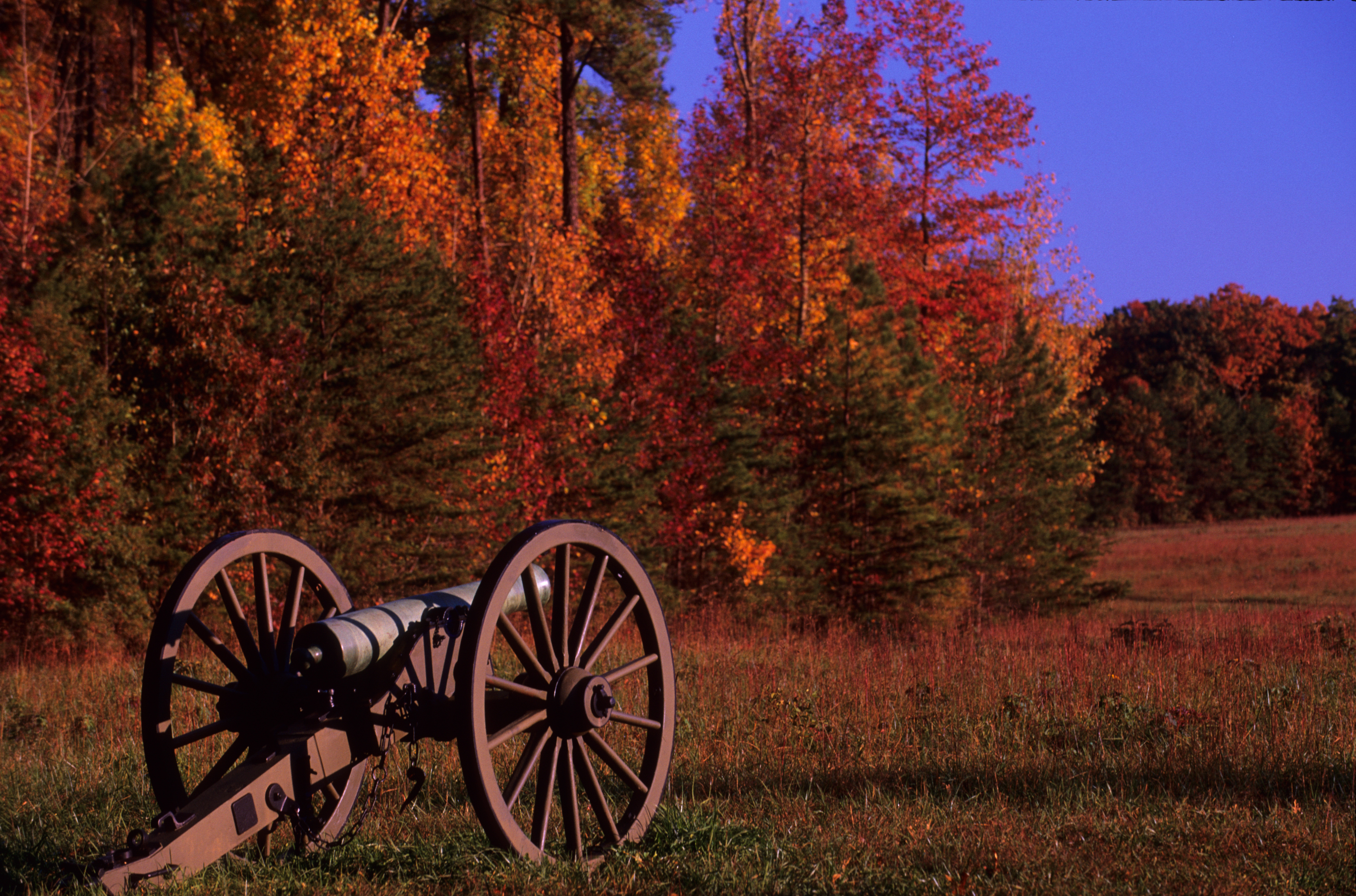
The Wilderness Battlefield
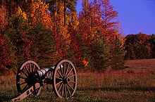 The Wilderness Battlefield - Widow Tapp Field
The Battle of the Wilderness was fought in Orange County on May 5–6, 1864. The battle marked the first occasion legendary Generals Ulysses S. Grant and Robert E. Lee would face each other in battle. The fighting at the Wilderness was also the first battle in Grant's Overland Campaign that would ultimately lead to the fall of Richmond and Lee’s surrender at Appomattox.
Over 160,000 troops were engaged at the Wilderness in a bloody, see-saw, battle that saw both sides on the brink of destruction. When the guns fell silent on May 7, over 29,000 soldiers lay dead or wounded on the fields at the Wilderness, and Grant’s Union army was able to disengage and press on toward Richmond.
Today, the Battle of the Wilderness is a part of the Fredericksburg and Spotsylvania National Military Park, which has preserved 2,773 acres (11.22 km2) of the original battlefield. The park is closed on New Years Day, Thanksgiving and Christmas Day. Otherwise the park grounds are open from dawn to dusk on a daily basis.
Ellwood
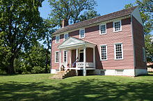 Ellwood Manor
The Ellwood Manor is the only surviving house that witnessed the Battle of the Wilderness in May 1864. During the battle Ellwood became a base of operations for the Union Army as Union General Ulysses S. Grant made his headquarters nearby. Ellwood would also play a role in the Battle of Chancellorsville in 1863 when Confederate General Stonewall Jackson, who was wounded during the battle, had his arm amputated and buried in the family cemetery at Ellwood. Following the battle at Chancellorsville, Ellwood served as a Confederate hospital.
In 2008, Ellwood was named “Favorite Virginia Civil War Site” by the Rappahannock Electric Cooperative’s “Cooperative Living” magazine.[8]
Doctor Holladay House

Formerly called the Doctor Holladay House, the Holladay House in Orange, Virginia (c.a. 1830) is on the nationally-recognized Journey Through Hallowed Ground. Named for Dr. Lewis Holladay, a prominent Virginia physician, the Holladay House has witnessed almost two centuries of American history. The building is historically significant because it is one of only a few antebellum structures still standing in Orange, Virginia.
Since approximately 1830, the Holladay House has served as a mercantile store, a residence, a doctor’s office, and a Virginia bed and breakfast inn. In the early 20th century, a private schoolhouse for local children was also on the property. Only a handful of proprietors have owned the home, and the Holladay family was its steward for over 100 years. The Holladay House still boasts much of its original woodwork, including floors, mantels, doors and period antiques from the Holladay family.
Now a Virginia bed and breakfast inn, the Holladay House is one of the two oldest standing structures in historic downtown Orange, and is registered with the National Register of Historic Places as part of the Orange Commercial Historic District. It has been a landmark on Main Street for generations.
Portions of Orange County lie within the Monticello AVA. Several award-winning wineries are within the county, including Barboursville Vineyards, Burnley Vineyards and Horton Vineyards.
Development concerns
As of September 2008, Wal-Mart has submitted a proposal to build a 141,000-square-foot (13,100 m2) Supercenter store less than one quarter mile from the National Park Service Boundary of the Wilderness Battlefield. It would be situated on a 52-acre (210,000 m2) tract just north of the Route 3/Route 20 intersection in Orange County. Preservation groups have formed the Wilderness Battlefield Coalition to oppose the construction of this Wal-Mart, arguing that it is likely to produce a significant increase in traffic and subsequent development.[9]
See also
- National Register of Historic Places listings in Orange County, Virginia
- Orange Volunteer Fire Company
References
- ^ [1]. Weldon Cooper Center 2010 Census Count Retrieved September 9, 2011
- ^ "Find a County". National Association of Counties. http://www.naco.org/Counties/Pages/FindACounty.aspx. Retrieved 2011-06-07.
- ^ John Gwathmey, 1937, Twelve Virginia Counties p. 277.
- ^ "American President: Zachary Taylor". Miller Center of Public Affairs. http://millercenter.org/academic/americanpresident/taylor. Retrieved 2008-10-21.
- ^ "American FactFinder". United States Census Bureau. http://factfinder.census.gov. Retrieved 2008-01-31.
- ^ Virginia, State of (1998-2009). "Virginia.gov - Education - Home Page". http://www.state.va.us/cmsportal3/education_4096/schools,_libraries_and_museums_4101/k-12_schools_4356/index.html. Retrieved 2009-05-30.
- ^ Schools, Orange County Public. "Orange County Schools Office of the Superintendent". http://www.ocss-va.org/departments/superintendent/index.htm. Retrieved 2009-05-30.
- ^ Ellwood named favorite Virginia Civil War site - Culpeper Star-Exponent
- ^ Groups want to sidetrack Orange project - Fredericksburg Free-Lance Star
External links
- Orange County official government site
- Orange County Historical Society
- Memorial Foundation of the Germanna Colonies in Virginia
- The Wilderness Battlefield Coalition - Help Stop the Wilderness Walmart

Madison County Culpeper County Greene County 
Spotsylvania County  Orange County, Virginia

Albemarle County Louisa County Municipalities and communities of Orange County, Virginia Towns 
CDP Lake of the Woods
Unincorporated
communitiesBarboursville‡ | Bledsoe Corner | Burr Hill | Lahore | Locust Grove | Montpelier Station | Rhoadesville | Scuffletown | Unionville
Footnotes ‡This populated place also has portions in an adjacent county or counties
Categories:- Virginia counties
- Orange County, Virginia
- 1734 establishments in the Thirteen Colonies
- Populated places established in 1734


Wikimedia Foundation. 2010.