- Piscataqua River
Geobox River
name = Piscataqua River
native_name =
other_name =
other_name1 =

image_size = 300
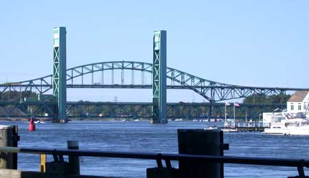
image_caption = Piscataqua River from Portsmouth, NH, with theSarah Mildred Long Bridge and thePiscataqua River Bridge (background).
country =USA
country1 =
state =New Hampshire
state1 =Maine
state2 =
state3 =
region =
region1 =
district =
district1 =
city =
city1 =
length_imperial = 12
watershed_imperial =
discharge_location =
discharge_average_imperial =
discharge_max_imperial =
discharge_min_imperial =
discharge1_location =
discharge1_average_imperial =
source_name = Cochecho andSalmon Falls River s
source_location =
source_district =
source_region =
source_state =New Hampshire /Maine border
source_country =USA
source_lat_d = 43
source_lat_m = 10
source_lat_s = 34
source_lat_NS = N
source_long_d = 70
source_long_m = 49
source_long_s = 29
source_long_EW = W
source_elevation_imperial = 0
source_length_imperial =
mouth_name =Atlantic Ocean
mouth_location = Portsmouth Harbor
mouth_district =
mouth_region =
mouth_state =New Hampshire /Maine border
mouth_country =USA
mouth_lat_d = 43
mouth_lat_m = 3
mouth_lat_s = 22
mouth_lat_NS = N
mouth_long_d = 70
mouth_long_m = 42
mouth_long_s = 11
mouth_long_EW = W
mouth_elevation_imperial = 0
tributary_left =Salmon Falls River
tributary_left1 =
tributary_right =Cochecho River
tributary_right1 = Great Bay
free_name =
free_value =
map_size =
map_caption = The Piscataqua River, in the northeasternUnited States , is a convert|12|mi|adj=on long tidalestuary formed by the confluence of the Salmon Falls and Cochecho rivers. The drainage basin of the river is approximately convert|1495|sqmi. The river runs southeastward, determining part of the boundary between the states ofNew Hampshire andMaine , and empties into theAtlantic Ocean east ofPortsmouth, New Hampshire . The last six miles before the sea form one of the finestharbor s in the northeastern United States, despite a tidal current rated as one of the fastest in North America (at Nobles Island across from downtown Portsmouth). [ [http://tidesandcurrents.noaa.gov/faq4.html#70 NOAA "Tides & Currents fact sheet] ] Named by the area's originalAbenaki inhabitants, "Piscataqua" combines "peske" (branch) with "tegwe" (a river with a strong current, possibly tidal). "Peske-tegwe", then, describes a place where a river separates into two or three parts, or literally, "a place where boats orcanoe s ascending the river together from its mouth were compelled to separate according to their several destinations" -- for example, at Dover Point. The first knownEurope an to explore the river wasMartin Pring in 1603. Captain John Smith placed a spelling similar to "Piscataqua" for the region on his map of 1614. The river was site of the firstsawmill in the colonies in 1623, the same year the contemporary spelling "Piscataqua" was first recorded.The
Portsmouth Naval Shipyard is located onSeavey's Island inKittery, Maine near the Piscataqua's mouth. The dispute between New Hampshire and Maine over ownership of Seavey’s Island was settled by the U.S. Supreme Court in 2001, locating the state border at the center of the river's navigable channel.cite web |title=Supreme Court Collection |url=http://www.law.cornell.edu/supct/html/130ORIG.ZS.html |work=Cornell Law School |accessdate=2007-05-22]See also
*
List of New Hampshire rivers
*List of Maine rivers
*Great Bay
*Memorial Bridge (Portsmouth, New Hampshire) External links
* [http://www.mainerivers.org/piscataqua.html MaineRivers.org] Piscataqua River
* [http://www.utulsa.edu/law/classes/rice/Constitutional/Storey/story_history_newhampshire.html History as Border of New Hampshire]References
* Ralph May, "Piscataqua, The Correctness of Use and the Meaning of the Word" (1966), Randall Press, Portsmouth, NH
* [http://www.oyez.org/oyez/resource/case/1247/ New Hampshire v. Maine (2001)] U.S. Supreme Court Case regarding border dispute
Wikimedia Foundation. 2010.
