- Chesapeake Bay Interpretive Buoy System
-
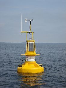 The Patapsco River Chesapeake Bay Interpretive Buoy System smart buoy in July 2007.
Chesapeake Bay Interpretive Buoy System (CBIBS) is a network of observational buoys that are deployed throughout the Chesapeake Bay to observe the estuary's changing conditions and to serve as way points along the Captain John Smith Chesapeake National Historic Trail. They are maintained by the United States National Oceanic and Atmospheric Administration (NOAA). These "smart buoys" observe and record meteorological, oceanographic and water quality data which can be obtained in real-time by calling 1-877-BUOY-BAY or by logging on to http://buoybay.noaa.gov/. CBIBS is the only operational buoy system in the Chesapeake Bay dedicated to maintaining the broad range of measurements necessary to track Bay restoration progress.[1]
Contents
Location of the buoys
There are ten operational buoys in the system located:
- at the mouth of the Susquehanna River (near Havre de Grace, Maryland) 39°32.541′N 76°04.495′W / 39.54235°N 76.074917°W[2]
- at the mouth of the Patapsco River (near Baltimore) 39°09′07″N 76°23′28″W / 39.15191°N 76.39115°W[3]
- at the mouth of the Severn River (near Annapolis, Maryland) 38°57′47″N 76°26′51″W / 38.9631°N 76.4475°W[4]
- in the Upper Potomac River south of the Woodrow Wilson Bridge (near Alexandria, Virginia) 38°47′15.6″N 77°02′08.34″W / 38.787667°N 77.03565°W[5]
- off the mouth of the Little Choptank River 38°33.375′N 76°24.882′W / 38.55625°N 76.4147°W[6]
- at the mouth of the Potomac River (near Point Lookout, Maryland) 38°01′59″N 76°20′08″W / 38.033°N 76.3355°W[7]
- at the mouth of the Rappahannock River (near Stingray Point and Deltaville, Virginia) 37°33′06″N 76°15′05″W / 37.5517°N 76.2514°W[8]
- in the James River (near Jamestown, Virginia) 37°12′15″N 76°46′39″W / 37.20417°N 76.7775°W[9]
- in the Elizabeth River (near Norfolk, Virginia) 36°50′44″N 76°17′53″W / 36.8455°N 76.298°W[10]
- at the mouth of the Chesapeake Bay (near Cape Henry, Virginia) 36°58′45″N 76°02′37″W / 36.9793°N 76.0436°W[11]
Types of data observed
The buoys observe and record a wide variety of meteorological, oceanographic, and water quality real-time data including air temperature, relative humidity, barometric pressure, wind speed and direction, wave height and direction, currents, water temperature, salinity, dissolved oxygen, chlorophyll, and turbidity. Anyone can obtain the data by calling 1-877-BUOY-BAY or by going to http://buoybay.noaa.gov/.
Some buoys in the network have experimental sensors that record changes in water level and nutrient (nitrogen and phosphorus) pollution levels. The James River buoy has an instrument that can track the passage of Atlantic sturgeon tagged by scientists.
Relationship to other ocean observing systems
CBIBS is a component of the Chesapeake Bay Observing System (CBOS) and the U.S. Integrated Ocean Observing System (IOOS).[1]
Partners
A variety of partners contribute to the Chesapeake Bay Interpretive Buoy System including the U.S. Coast Guard and Coast Guard Auxiliary, the National Park Service, the U.S. Army Corps of Engineers, the Conservation Fund, the National Geographic Society, the Chesapeake Bay Foundation, the Friends of the John Smith Chesapeake Trail, Dominion Power, and the Nauticus museum (located in Norfolk, Virginia).
Data users
CBIBS data is relied on by a variety of users including recreational boaters, fishermen, commercial mariners, scientists, educators, and natural resource decision makers.
Link to the National Historic Trail
In addition to providing real-time data about the Bay's changing conditions, CBIBS also marks and interprets the Captain John Smith Chesapeake National Historic Trail, the first water trail in the National Historic Trail System. This trail is administered by the National Park Service and commemorates Captain Smith's exploratory voyages in the Bay during the summer of 1607 and 1608.
References
 This article incorporates public domain material from websites or documents of the National Oceanic and Atmospheric Administration.
- ^ a b "Frequently Asked Questions". Chesapeake Bay Interpretive Buoy System. http://buoybay.noaa.gov/about/faq.html. Retrieved July 14, 2011.
- ^ "Chesapeake Bay Interpretive Buoy System: Susquehanna River – S". Chesapeake Bay Interpretive Buoy System. http://buoybay.noaa.gov/locations/susquehanna.html. Retrieved July 14, 2011.
- ^ "Chesapeake Bay Interpretive Buoy System: Patapsco River – SN". Chesapeake Bay Interpretive Buoy System. http://buoybay.noaa.gov/locations/patapsco.html. Retrieved July 14, 2011.
- ^ "Chesapeake Bay Interpretive Buoy System: Annapolis – AN". Chesapeake Bay Interpretive Buoy System. http://buoybay.noaa.gov/locations/annapolis.html. Retrieved July 14, 2011.
- ^ "Chesapeake Bay Interpretive Buoy System: Upper Potomac – UP". Chesapeake Bay Interpretive Buoy System. http://buoybay.noaa.gov/locations/upper-potomac.html. Retrieved July 14, 2011.
- ^ "Chesapeake Bay Interpretive Buoy System: Gooses Reef – GR". Chesapeake Bay Interpretive Buoy System. http://buoybay.noaa.gov/locations/gooses-reef.html. Retrieved July 14, 2011.
- ^ "Chesapeake Bay Interpretive Buoy System: Potomac – PL". Chesapeake Bay Interpretive Buoy System. http://buoybay.noaa.gov/locations/potomac.html. Retrieved July 14, 2011.
- ^ "Chesapeake Bay Interpretive Buoy System: Stingray Point – SR". Chesapeake Bay Interpretive Buoy System. http://buoybay.noaa.gov/locations/stingray-point.html. Retrieved July 14, 2011.
- ^ "Chesapeake Bay Interpretive Buoy System: Jamestown – J". Chesapeake Bay Interpretive Buoy System. http://buoybay.noaa.gov/locations/jamestown.html. Retrieved July 14, 2011.
- ^ "Chesapeake Bay Interpretive Buoy System: Norfolk (N)". Chesapeake Bay Interpretive Buoy System. http://buoybay.noaa.gov/locations/norfolk.html. Retrieved July 14, 2011.
- ^ "Chesapeake Bay Interpretive Buoy System: First Landing (FL)". Chesapeake Bay Interpretive Buoy System. http://buoybay.noaa.gov/locations/first-landing.html. Retrieved August 17, 2011.
External links
Categories:- Buoyage
- Chesapeake Bay Watershed
- James River Watershed
- Maritime safety
- National Oceanic and Atmospheric Administration
- Navigation
- Potomac River Watershed

Wikimedia Foundation. 2010.