- Celtic Sea
-
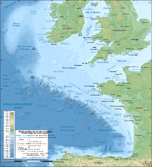
The Celtic Sea (Irish: An Mhuir Cheilteach; Welsh: Y Môr Celtaidd; Cornish: An Mor Keltek; Breton: Ar Mor Keltiek; French: La mer Celtique) is the area of the Atlantic Ocean off the south coast of Ireland bounded to the east by Saint George's Channel;[1] other limits include the Bristol Channel, the English Channel, and the Bay of Biscay, as well as adjacent portions of Wales, Cornwall, Devon, and Brittany. The southern and western boundaries are delimited by the continental shelf, which drops away sharply.
Contents
History
The Celtic heritage of the bounding lands to the north and east gives the sea its name,[2] first proposed by E. W. L. Holt at a 1921 meeting in Dublin of fisheries experts from England, Ireland, Scotland and France.[2] The northern portion of this sea had previously been considered as part of Saint George's Channel and the southern portion as an undifferentiated part of the "Southwest Approaches" to Britain. The need for a common name came to be felt because of the common marine biology, geology and hydrology.[2] It was adopted in France before being common in the English-speaking countries.[2] It was adopted by marine biologists and oceanographers, and later by oil exploration firms.[3] It is named in a 1963 British atlas,[4] but a 1972 article states "what British maps call the western approaches, and what the oil industry calls the Celtic Sea [...] certainly the residents on the western coast [of Great Britain] don't refer to it as such."[5]
Limits
There are no land features to divide the Celtic Sea from the open Atlantic Ocean to the south and west. For these limits, Holt suggested the 200 fathom (366 m) marine contour and the island of Ushant off the tip of Brittany.
The definition approved by 1974 by the Hydrographer of the Royal Navy for use in Admiralty Charts was "bounded roughly by lines joining Ushant, Land's End, Hartland Point, Lundy Island, St. Govan's Head and Rosslare, thence following the Irish coast south to Mizen Head and then along the 200-metre isobath to approximately the latitude of Ushant."[6]
The International Hydrographic Organization defines the limits of the Celtic Sea as follows:[7]
On the North. The Southern limit of the Irish Sea [a line joining St David's Head to Carnsore Point], the South coast of Ireland, thence from Mizen Head a line drawn to a position 51°0′N 11°30′W / 51°N 11.5°W.
On the West and South. A line from the position 51°0′N 11°30′W / 51°N 11.5°W South to 49°N, thence to latitude 46°30'N on the Western limit of the Bay of Biscay [a line joining Cape Ortegal to Penmarch Point], thence along that line to Penmarch Point.
On the East. The Western limit of the English Channel [a line joining Île Vierge to Land's End] and the Western limit of the Bristol Channel [a line joining Hartland Point to St. Govan's Head].
Seabed
The seabed under the Celtic Sea is called the Celtic Shelf, part of the continental shelf of Europe. The northeast portion has a depth of between 90m and 100m, increasing towards Saint George's Channel. In the opposite direction, sand ridges pointing southwest have a similar height, separated by troughs approximately 50m deeper. These ridges were formed by tidal effects when the sea level was lower. South of 50° the topography is more irregular.[8]
Oil and gas exploration in the Celtic Sea has had limited commercial success. The Kinsale Head gas field supplied much of the Republic of Ireland in the 1980s and 1990s.
See also
References
- ^ C.Michael Hogan. 2011. Celtic Sea. eds. P.saundry & C.Cleveland. Encyclopedia of Earth. National Council for Science and the /environment. Washington DC.
- ^ a b c d Haslam, D. W. (Hydrographer of the Royal Navy) (March 29, 1976; Issue 59665). "It's the Celtic Sea—official". The Times: p. 15 (Letters to the Editor), col G.
- ^ Cooper, L. H. N. (February 02, 1972; Issue 58391). "In Celtic waters". The Times: p. 20; col G (Letters to the Editor).
- ^ The Atlas of Great Britain and Northern Ireland. Clarendon Press. 1963. pp. 20–21.; cited in
Shergold, Vernon G. (January 27, 1972; Issue 58386). "Celtic Sea: a good name". The Times: p. 20 (Letters to the Editor); col G. - ^ Vielvoye, Roger (January 24, 1972; Issue 58383). "Industry in the regions Striking oil in Wales and West Country". The Times: p. 19; col A.
- ^ Parliamentary Debates, House of Commons, 16 December 1974, column 317W.
- ^ "Limits of Oceans and Seas, 3rd edition + corrections". International Hydrographic Organization. 1971. p. 42 [corrections to page 13]. http://www.iho-ohi.net/iho_pubs/standard/S-23/S23_1953.pdf. Retrieved 6 February 2010.
- ^ Hardisty, Jack (1990). The British Seas: an introduction to the oceanography and resources of the north-west European continental shelf. Taylor & Francis. pp. 20–21. ISBN 0415035864.
External links
- Coccoliths in the Celtic Sea: a bloom of phytoplankton in the Celtic Sea, visible from outer space in an MISR image, 4 June 2001
Categories:- Celtic Sea
- Republic of Ireland–United Kingdom border

Wikimedia Foundation. 2010.