- Mizen Head
-
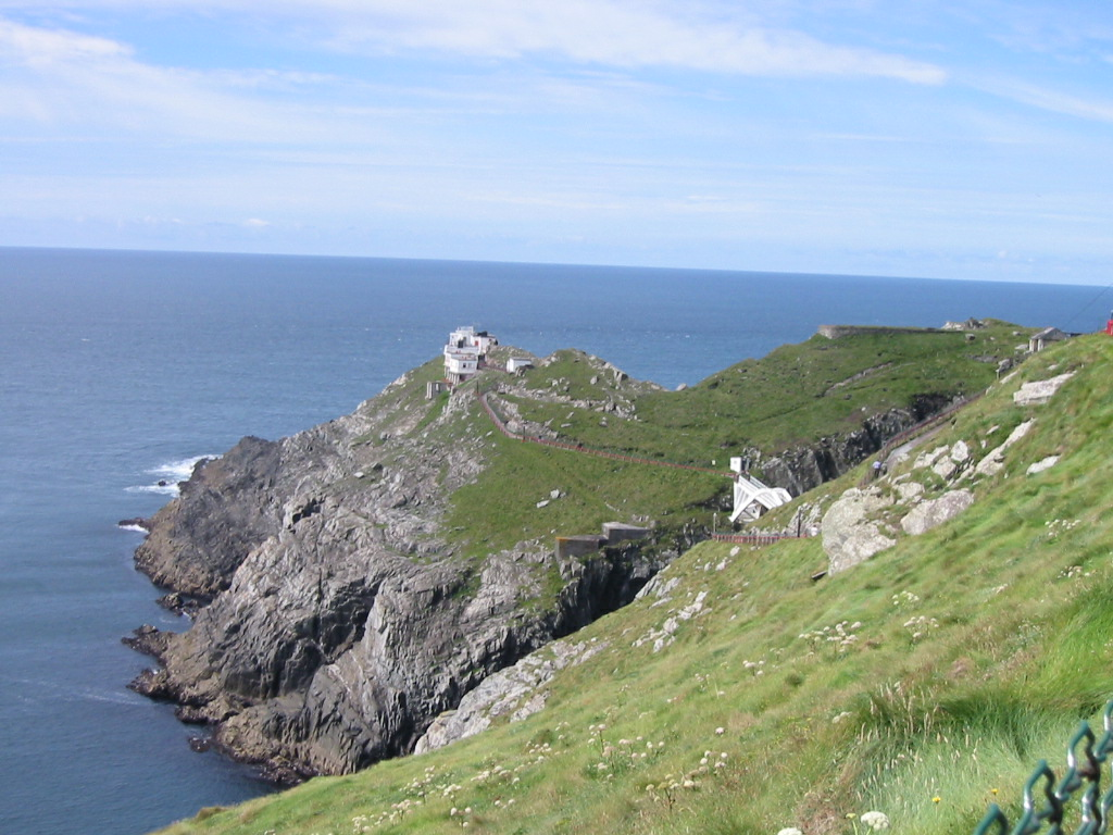
 Mizen Head: the most south-westerly point of Ireland
Mizen Head (Irish: Carn Uí Néid), is located at the extremity of a peninsula in the district of Carbery in County Cork, Ireland. It is one of the extreme points of the island of Ireland and is a major tourist attraction, noted for its dramatic cliff scenery. The tip of the peninsula is an island formed by a deep chasm, now spanned by a bridge; this gives access to an old signalling station, a weather station, and a lighthouse. The signalling station, once permanently manned, is now a museum housing displays relating to the site's strategic significance for transatlantic shipping and communications. The "99 steps" which formed part of the original access route have been supplemented by a series of paths and viewing platforms, and a full range of visitor facilities is available at the entrance to the site. The villages of Ballydehob, Crookhaven, Goleen, and Schull are located on the peninsula to the east.
Contrary to popular belief, Mizen Head is not the most southerly point on the mainland of Ireland - nearby Brow Head holds that title. Nevertheless, geography books have long measured the length of Ireland "from Fair Head to Mizen Head"[1] or "from Malin Head to Mizen Head.[2]
Contents
See also
- Malin to Mizen
- Carbery's Hundred Isles
References
Sources
- Mizen Journal, Archaeology Paddy O'Leary, No 11, 2003 ISSN 1649-203X
- Archaeological Inventory of County Cork, Vol 1 West Cork, Office of Public Works, 1992 ISBN 0-7076-0175-4
- BHAS Journal vol 2 p.106-119, Townlands Donal Fitzgerald ISSN 0791-6612
- Northside of the Mizen, General reading, Patrick McCarthy & Richard Hawkes
External links
- Mizen Head Pictures and Travel Guide
- http://www.irelandaerialphotography.com/aerial_photos/000383_mizen_head.html Mizen Head and lighthouse aerial photo
- 360 Virtual Tour of Mizen Head
Coordinates: 51°27′1″N 9°49′10″W / 51.45028°N 9.81944°W
Irish lighthouses Lighthouses are shown in anti-clockwise sequence beginning from the north and proceeding west, south, east, and back to north. County Donegal Inishowen · Inishtrahull · Fanad · Dunree · Buncrana · Tory Island · Arranmore · Ballagh Rocks · Rathlin O'Birne · Rotten Island · St. John's

County Sligo Blackrock · Lower Rosses Point · Metal Man · Oyster Island
County Mayo Broadhaven · Eagle Island · Blackrock · Blacksod Bay · Achillbeg · Inishgort
County Galway Slyne Head Cashla Bay · Eeragh · Straw Island · Inisheer
County Clare Blackhead · Loop Head · Kilcredaun Head · Corlis Point Front · Corlis Point Rear · Scattery Island
County Kerry Little Samphire Island · Inishtearaght · Cromwell Point · Valentia Rear · Valentia Front · Skelligs
County Cork Bull Rock · Ardnakinna · Castletown Directional Light · Roancarrig · Sheep's Head · Mizen Head · Crookhaven · Copper Point · Fastnet Rock · Baltimore Beacon · Galley Head · Old Head of Kinsale · Charlesfort · Roches Point · Ballycotton · Youghal
County Waterford Mine Head · Ballinacourty Point · Dunmore East
County Wexford County Wicklow County Dublin Muglins · Poolbeg · Kish Bank · Baily · Howth Head · Rockabill
County Louth County Down Green Island · Vidal Bank · Haulbowline · St. John's Point · ` Angus Rock · Donaghadee · Mew Island
County Antrim Blackhead · Chaine Tower · The Maidens · Rathlin East · Rue Point · Rathlin West
List of lighthouses in Ireland · Lightvessels in Ireland · Commissioners of Irish Lights · Category:Lighthouses in Ireland · List of islands of Ireland · Coastal landforms of Ireland Categories:- Headlands of County Cork
- Visitor attractions in County Cork

Wikimedia Foundation. 2010.