- County Waterford
-
County Waterford
Contae Phort Láirge
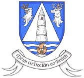
Coat of armsMotto: Déisi oc Declán co Bráth (Irish)
"May the Déise remain with Declan forever"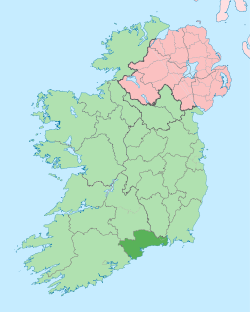
Country Ireland Province Munster Dáil Éireann Tipperary South
WaterfordEU Parliament South County seat Waterford Government - Type County Council and City Council Area - Total 1,857 km2 (717 sq mi) Area rank 20th Population (2011) 113,707 - Rank 20th Car plates W (city) & WD (county) Website waterfordcoco.ie County Waterford (Irish: Contae Phort Láirge) is a county in Ireland. It is part of the South-East Region and is also located in the province of Munster. It is named after the city of Waterford which is derived from the Old Norse name Veðrafjǫrðr or Vedrarfjord. Waterford County Council and Waterford City Council are the local authorities for the county. There is an Irish-speaking area in the south of the county. The population of the county is 113,707 according to the 2011 census.
Contents
Geography and political subdivisions
County Waterford has two mountain ranges, the Knockmealdown Mountains and the Comeragh Mountains. The highest point in the county is Knockmealdown, at 794m. It also has many rivers, including Ireland's third longest river, the River Suir (184 km); and Ireland's fourth longest river, the Munster Blackwater (168 km). There are over 30[citation needed] beaches along Waterford's volcanic[citation needed] coast line. A large stretch of this coastline, known as the Copper Coast has been designated as a UNESCO Geopark, a place of great geological importance. The area around Ring (An Rinn) is a Gaeltacht, an Irish-speaking area.
Dungarvan is the county seat[1] for Waterford County Council.
Baronies
There are eight historic baronies in the county: Coshmore and Coshbride, Decies-within-Drum, Decies-without-Drum, Gaultiere, Glenahiry, Middle Third, Upperthird and Waterford City.
Towns and villages
Historical populations Year Pop. ±% 1653 13,136 — 1659 13,286 +1.1% 1821 76,103 +472.8% 1831 85,217 +12.0% 1841 196,187 +130.2% 1851 164,035 −16.4% 1861 134,252 −18.2% 1871 123,310 −8.2% 1881 112,768 −8.5% 1891 98,251 −12.9% 1901 87,187 −11.3% 1911 83,966 −3.7% 1926 78,562 −6.4% 1936 77,614 −1.2% 1946 76,108 −1.9% 1951 75,061 −1.4% 1956 74,031 −1.4% 1961 71,439 −3.5% 1966 73,080 +2.3% 1971 77,315 +5.8% 1979 87,278 +12.9% 1981 88,591 +1.5% 1986 91,151 +2.9% 1991 91,624 +0.5% 1996 94,680 +3.3% 2002 101,546 +7.3% 2006 107,961 +6.3% 2011 113,707 +5.3% [2][3][4][5][6][7] - Abbeyside, Affane, Aglish, Annestown, An Rinn, Ardmore
- Ballinacourty, Ballinameela, Ballinamult, Ballinroad, Ballybeg, Ballybricken, Ballyduff Lower, Ballyduff Upper, Ballydurn, Ballygunner, Ballylaneen, Ballymacarbry, Ballymacart, Ballynaneashagh, Ballysaggart, Ballytruckle, Bilberry, Bunmahon, Butlerstown
- Cappoquin, Carrickbeg, Carriglea, Cheekpoint, Clashmore, Clonea-Power, Clonea Strand, Colligan, Coolnasmear, Crooke
- Dungarvan, Dunhill, Dunmore East
- Faha, Faithlegg, Fenor, Ferrybank, Fews, Fourmilewater
- Glencairn, Grange
- Helvick Head
- Kilbrien, Kilgobinet, Kill, Killea, Kilmacthomas, Kilmanahan, Kilmeaden, Kilrossanty, Kilwatermoy, Kinsalebeg, Knockanore
- Lemybrien, Lisduggan, Lismore
- Mahon Bridge, Mine Head, Modeligo, Mothel, Mount Congreve, Mount Mellaray
- Newtown
- Old Parish
- Passage East, Portlaw
- Rathgormack
- Sliabh gCua, Stradbally
- Tallow, Tramore, Touraneena, Tourin, Tycor
- Waterford, Whitechurch, Whiting Bay, Woodstown
- Villierstown
History
County Waterford is colloquially known as "The Déise" (An Déise). Some time between the 4th and 8th centuries, a tribe of native Gaelic people called the Déisi were driven from southern county Meath/north Kildare, conquering and settling here. The ancient principality of the Déise is today roughly coterminous with the current Roman Catholic Diocese of Waterford and Lismore. The westernmost of the baronies are "Decies within Drum" and "Decies without Drum", separated by the Drum-Fineen hills.[8] There are many megalithic tombs and ogham stones[9] in the county. The Viking influence can still be seen with Reginald's Tower, one of the first buildings to use a bricks and mortar construction method in Ireland. Woodstown, a settlement dating to the 9th Century was discovered 5.5 kilometres west of Waterford city. It was the largest settlement outside of Scandinavia and the only large-scale 9th Century Viking settlement discovered to date in Western Europe. Other architectural features are products of the Anglo-Norman Invasion of Ireland and its effects.
Location Grid

County Tipperary Northeast: County Kilkenny County Cork 
County Wexford  County Waterford

Celtic Sea Local government and politics
The area of the county is now covered by two local administrative authorities: Waterford County Council and Waterford City Council. They rank equally as first level local administrative units of the NUTS 3 South-East Region for Eurostat purposes. There are 34 LAU 1 entities in the Republic of Ireland. The remit of Waterford County Council includes some suburbs of the city not within the remit of Waterford City Council. Both local authorities are responsible for certain local services such as sanitation, planning and development, libraries, the collection of motor taxation, local roads and social housing.
The county is part of the South constituency for the purposes of European elections. For elections to Dáil Éireann, the county is divided between two constituencies: Waterford and Tipperary South. Together they return 7 deputies (TDs) to the Dáil. The Electoral (Amendment) Act 2009 defines the Waterford constituency as "The county of Waterford, except the part thereof which is comprised in the constituency of Tipperary South; and the city of Waterford."."[10]
See also
- List of abbeys and priories in the Republic of Ireland (County Waterford)
- Saint Declan
- Lord Lieutenant of Waterford
- High Sheriff of County Waterford
References
- ^ "Waterford County Council website". http://www.waterfordcoco.ie/en/localauthorities/waterfordcountycouncil/.
- ^ For 1653 and 1659 figures from Civil Survey Census of those years, Paper of Mr Hardinge to Royal Irish Academy March 14, 1865.
- ^ Census for post 1821 figures.
- ^ http://www.histpop.org
- ^ http://www.nisranew.nisra.gov.uk/census
- ^ Lee, JJ (1981). "On the accuracy of the Pre-famine Irish censuses". In Goldstrom, J. M.; Clarkson, L. A.. Irish Population, Economy, and Society: Essays in Honour of the Late K. H. Connell. Oxford, England: Clarendon Press.
- ^ Mokyr, Joel; O Grada, Cormac (November). "New Developments in Irish Population History, 1700-1850". The Economic History Review 37 (4): 473–488. doi:10.1111/j.1468-0289.1984.tb00344.x. http://www3.interscience.wiley.com/journal/120035880/abstract.
- ^ Egan, P.M. (20 November 2004) [1893]. "Early Waterford History 2. The Decies". History of Waterford. http://www.waterfordcountymuseum.org/exhibit/web?task=Display&art_id=184&pagenum=2. Retrieved 2008-02-23.
- ^ "Prehistoric Waterford tombs, dolmens and standing stones.". http://www.prehistoricwaterford.com/sites-a-z/.
- ^ "Electoral (Amendment) Act 2009: Schedule". Irish Statute Book database. http://www.irishstatutebook.ie/2009/en/act/pub/0004/sched.html. Retrieved 29 September 2010.
External links
- Waterford County Council website
- Waterford County Museum – 3500 pages of County Waterford history
- Waterford County Image Archive – Thousands of photos and images from County Waterford history
- WaterfordTourism.org – Official Waterford Tourism website
- The Diocese of Waterford and Lismore
- Work in Waterford- Provide assistance for people who wish to work in county Waterford.
- Invest in Waterford- an initiative by Waterford County Council to encourage industry to invest in County Waterford.
Places in County Waterford County town: Waterford Towns 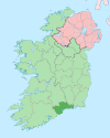
Villages and
TownlandsAbbeyside · Affane · Aglish · An Rinn · Annestown · Ardmore · Ballinacourty · Ballinameela · Ballinamult · Ballinroad · Ballybeg · Ballylaneen · Bunmahon · Cappoquin · Carrickbeg · Clashmore · Dunmore East · Fenor · Ferrybank · Grange · Kill · Kilmacthomas · Kilmeaden · Knockanore · Lemybrien · Mahon Bridge · Mothel · Old Parish · Passage East · Portlaw · Rathgormack · Sliabh gCua · Talllow · Touraneena · Villierstown · Whitechurch · Woodstown
List of townlands in County Waterford · Category:Mountains and hills of County Waterford · Category:Rivers of County Waterford · Category:Geography of County Waterford Counties of Ireland The counties are listed per province Connacht 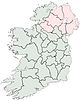
Munster Clare · Cork (Cork City) · Kerry · Limerick (Limerick City) · Tipperary (North Tipperary • South Tipperary) · Waterford (Waterford City)
Leinster Ulster Italics denote non-administrative counties. Brackets denote eponymous cities or non-traditional counties. † denotes counties of Northern Ireland Categories:- County Waterford
- Munster
- Counties of the Republic of Ireland
- Local administrative units of the Republic of Ireland

Wikimedia Foundation. 2010.