- NUTS of the Republic of Ireland
-
Main article: Nomenclature of Territorial Units for Statistics
The Nomenclature of Territorial Units for Statistics (NUTS) is a geocode standard for referencing the subdivisions of the Republic of Ireland for statistical purposes. The standard is developed and regulated by the European Union. The NUTS standard is instrumental in delivering the European Union's Structural Funds. The NUTS code for Ireland is IE and a hierarchy of three levels is established by Eurostat. The subdivisions correspond to administrative divisions within the country in all but the lowest level. Formerly, the further NUTS divisions (IV and V) existed; these have now been replaced by Local Administrative Units (LAU-1 and LAU-2 respoectively). In Ireland, the LAUs are structured as followed:
- LAU 1 – County councils (29) and their legal equivalent City councils (5).
- LAU 2 – District Electoral Divisions. This level, however, is not used for local government purposes.
Contents
Level Number of
SubdivisionsNUTS 1 1 (the entire state) NUTS 2 statistical regions 2 NUTS 3 statistical regions 8 NUTS levels 1, 2 and 3
Main article: NUTS 2 statistical regions of the Republic of IrelandNUTS 1 Code NUTS 2 Code NUTS 3 Code Republic
of IrelandIE0 Border, Midland and Western NUTS-II Region IE01 Border Region IE011 Midlands Region, Ireland IE012 West Region, Ireland IE013 Southern and Eastern NUTS-II Region IE02 Dublin Region IE021 Mid-East Region, Ireland IE022 Mid-West Region, Ireland IE023 South-East Region, Ireland IE024 South-West Region, Ireland IE025 Local administrative units
Main article: Local administrative unitFormerly known as NUTS level 4 and 5, these statistical levels are now known as Local Administrative Units (LAU). There are two such levels:
LAU level Subdivisions # LAU 1 Administrative counties and cities 34 LAU 2[1] District Electoral Division 3441 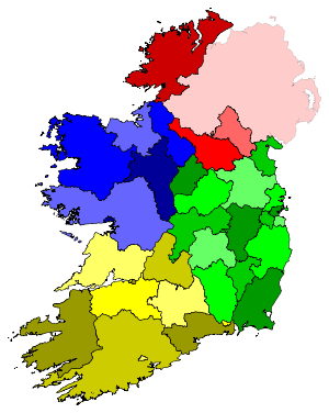 County County and City Council areas of the Republic of Ireland
County Council
or City CouncilNUTS 3
RegionPopulation
(2006) [2]Area
(km²)Population
DensityCouncil
Head officeCode[3] Louth County Council Border Region 111,267 831.99 133.7 Dundalk LH Leitrim County Council Border Region 28,950 1,588.85 18.2 Carrick-on-Shannon LM Sligo County Council Border Region 60,894 1,837.46 33.1 Sligo SO Cavan County Council Border Region 64,003 1,931.88 33.1 Cavan CN Donegal County Council Border Region 147,264 4,859.51 30.3 Lifford DL Monaghan County Council Border Region 55,997 1,295.92 43.2 Monaghan MN Laois County Council Midlands Region 67,059 1,719.46 39.0 Portlaoise LS Longford County Council Midlands Region 34,391 1,091.25 31.5 Longford LD Offaly County Council Midlands Region 70,868 1,989.81 35.6 Tullamore OY Westmeath County Council Midlands Region 79,346 1,824.86 43.5 Mullingar WH Galway City Council West Region 72,414 50.57 1,432.0 Galway G Galway County Council West Region 159,256 6,099.95 26.1 Galway G Mayo County Council West Region 123,839 5,588.31 22.2 Castlebar MO Roscommon County Council West Region 58,768 2,548.04 23.1 Roscommon RN - Border, Midland and Western NUTS-II Region - - - - - Dublin City Council Dublin Region 506,211 117.61 4,304.1 Dublin D Dún Laoghaire-Rathdown County Council Dublin Region 194,038 126.95 1,528.5 Dún Laoghaire D Fingal County Council Dublin Region 239,992 453.09 529.7 Swords D South Dublin County Council Dublin Region 246,935 223.01 1,107.3 Tallaght D Limerick City Council Mid-West Region, Ireland 52,539 20.35 2,581.8 Limerick L Limerick County Council Mid-West Region, Ireland 131,516 2,739.67 48.0 Limerick LK North Tipperary County Council Mid-West Region, Ireland 66,023 2,046.30 32.3 Nenagh TN Clare County Council Mid-West Region, Ireland 110,950 3,442.32 32.2 Ennis CE Kildare County Council Mid-East Region 186,335 1,694.20 110.0 Naas KE Meath County Council Mid-East Region 162,831 2,334.54 69.7 Navan MH Wicklow County Council Mid-East Region 126,194 2,032.60 62.1 Wicklow WW Wexford County Council South-East Region 131,749 2,365.27 55.7 Wexford WX Kilkenny County Council South-East Region 87,558 2,071.69 42.3 Kilkenny KK Carlow County Council South-East Region 50,349 897.90 56.1 Carlow CW South Tipperary County Council South-East Region 83,221 2,257.94 36.9 Clonmel TS Waterford City Council South-East Region 45,748 41.58 1,100.2 Waterford W Waterford County Council South-East Region 62,213 1,817.13 34.2 Dungarvan WD Cork City Council South-West Region 119,418 39.61 3,014.8 Cork C Cork County Council South-West Region 361,877 7,467.97 48.5 Cork C Kerry County Council South-West Region 139,835 4,734.65 29.5 Tralee KY - Southern and Eastern NUTS-II Region - - - - - Republic of Ireland - 4,239,848 70,182.24 60.4 - - See also
- ISO 3166-2 codes of Ireland
- FIPS region codes of Ireland
Sources
- The LAU codes of Ireland can be downloaded here: [1]

- Hierarchical list of the Nomenclature of territorial units for statistics - NUTS and the Statistical regions of Europe
- Overview map of EU Countries - NUTS level 1
- Correspondence between the NUTS levels and the national administrative units
- List of current NUTS codes
- Counties of Ireland, Statoids.com
References
- ^ Eurostat - Equivalence of DEDs to LAU-2 units in the Republic of Ireland
- ^ Central Statistics Office
- ^ The code refers to the code in use for the purpose of vehicle registration plates in Ireland. The code may straddle the jurisdictions of several council areas, as in the case of the four entities of the Dublin Region.
EU members AT Austria • BE Belgium • BG Bulgaria • CY Cyprus • CZ Czech Republic • DE Germany • DK Denmark • EE Estonia • ES Spain • FI Finland • FR France • GR Greece • HU Hungary • IE Ireland • IT Italy • LT Lithuania • LU Luxembourg • LV Latvia • MT Malta • NL Netherlands • PL Poland • PT Portugal • RO Romania • SE Sweden • SI Slovenia • SK Slovakia • UK United KingdomCandidate countries EFTA countries Categories:- NUTS
- Subdivisions of the Republic of Ireland
- Local administrative units of the Republic of Ireland
- Regions of the Republic of Ireland

Wikimedia Foundation. 2010.