- Dún Laoghaire
-
This article is about the town of Dún Laoghaire. For the parliamentary constituency, see Dún Laoghaire (Dáil Éireann constituency). For the song D.U.N L.A.O.G.H.A.I.R.E, see Like Clockwork.
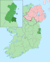
Dún Laoghaire — Town — Location in Ireland Coordinates: 53°18′N 6°08′W / 53.30°N 6.14°WCoordinates: 53°18′N 6°08′W / 53.30°N 6.14°W Country Ireland Province Leinster County Dun Laoghaire
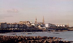
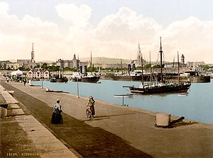
RathdownElevation 24 m (79 ft) Population (2006) - Urban 23,857 Irish Grid Reference O241284 Website dun-laoghaire.com Historical populations Year Pop. ±% 1821 1,506 — 1831 5,736 +280.9% 1841 7,229 +26.0% 1851 10,458 +44.7% 1861 12,469 +19.2% 1871 16,378 +31.3% 1881 18,586 +13.5% 1891 17,352 −6.6% 1901 17,377 +0.1% 1911 16,941 −2.5% 1926 35,111 +107.3% 1936 39,785 +13.3% 1946 44,674 +12.3% 1951 58,485 +30.9% 1956 64,855 +10.9% 1961 68,101 +5.0% 1966 84,818 +24.5% 1971 98,379 +16.0% 1981 120,607 +22.6% 1986 122,072 +1.2% 1991 180,693 +48.0% 1996 184,829 +2.3% 2002 186,641 +1.0% 2006 188,761 +1.1% [1][2][3][4][5] Dún Laoghaire or Dún Laoire (Irish pronunciation: [d̪ˠuːn̪ˠ ˈɫeːrʲə]), sometimes anglicised as "Dunleary"[citation needed] (English pronunciation: /dʌnˈlɪəri/), is a suburban seaside town in County Dublin, Ireland, about twelve kilometres south of Dublin city centre. It is the county town of Dun Laoghaire-Rathdown County and a major port of entry from Great Britain. From 1821 to 1921 it was officially called Kingstown.
Contents
Etymology
The town's name derives from Lóegaire mac Néill, a 5th century High King of Ireland, who chose the site as a sea base from which to carry out raids on Britain and Gaul. Dún is an Irish word meaning fort, and traces of fortifications from that period have been found on the coast. Some stone from that fort is preserved in the Maritime Museum.
The original Irish spelling is now almost always used in preference to its anglicised forms, although most Irish people pronounce it "Dunleary."
History
The present town of Dún Laoghaire dates from the 1820s. An earlier Dun Laoghaire village was located around the area where "The Purty Kitchen" pub is now located (sometimes mapped as "Old Dun Laoghaire"). Dun Laoghaire had a coffee house, and a small cove, both of which are shown on a number of old maps, and it may have had a salt mine (Salthill is close by). At that time, the area on which the town is currently located was a craggy, rocky pasture area with some quarries.
The events of the night of November 18/19, 1807 were to lead eventually to the transformation of the area. On that night, the troopships, the Prince of Wales, and the Rochdale, both of which had departed from Dublin, were driven on the rocks between Blackrock and Dun Laoghaire with the combined loss of over 400 lives. This disaster gave new impetus to an existing campaign for a new harbour to be constructed near Dublin. By 1816, the legislation was passed authorising the construction of what is now called the "West Pier". When King George IV came to visit the new port under construction in 1821, the name Dunleary was dropped in favour of the name "Kingstown"; the town returned to its former name with the creation of the Irish Free State in 1921.
Some maps show the commencement of a small town centre along what is now Cumberland St, close to the junction with York Road, but from the 1820s the harbour brought new business to the area, and a new town centre began to form along Georges St. That street may originally have been laid out as a military road connecting the Dún Laoghaire Martello Towers—one at the "Peoples Park", the other near the end of the West Pier—both of which have long disappeared.
Ireland's first railway from Dublin to Kingstown, opened for business in 1834, terminated near the West Pier. It established Kingstown as a preferred suburb of Dublin, and led to the construction of elegant residential terraces. By 1844 the "Atmospheric Train" (designed by Robert Mallet) connected Kingstown to Dalkey, leading to further development. The Atmospheric Train ceased in 1854, but was replaced by the extension of the railway, which was subsequently extended to the ferryport of Rosslare.
The main road to Dublin, through Monkstown village and Blackrock, was the sole road connection to the city of Dublin until 1932. In that year, the Eucharistic Congress, held in Dublin brought thousands of visitors to Dublin, and plans indicated that most of them would come through Dún Laoghaire. The road was considered inadequate, and a new coast road was created by connecting some short segments of road and closing some gardens. This road is now Seapoint Avenue. An agreement with the local residents to restore the area to pre-congress condition was never fulfilled.
The British 59th (2nd North Midland) Division disembarked at Kingstown in April 1916 and marched up the road to Dublin, in order to crush the Easter Rising. Adjacent to the Carlisle Pier and overlooked by the National Maritime Museum of Ireland, there is an anchor, recovered from the wreck of the mailboat RMS Leinster which was torpedoed over the Kish Bank in 1918, with the loss of over 500 lives.
Dún Laoghaire was hit by a stray German bomb during World War II, the bomb landing near the People's Park at Rosmeen Gardens. Damage from the bomb was limited to buildings.
Governance and representation
Dún Laoghaire was once the core element of the borough of Dún Laoghaire, and remains the only town in Ireland to have its own Vocational Education Committee. It is considered part of the Greater Dublin Area.
The area is governed locally by Dún Laoghaire-Rathdown County Council which is responsible for the provision of local services and amenities. For elections the town is part of the Dún Laoghaire local electoral area which elects six councillors. Following the 2009 local elections there are two councillors each from the Labour Party (centre left) and Fine Gael (centre right) and one each from Fianna Fáil (centrist) and PBPA (left wing).
For elections to Dáil Éireann the town is part of the Dún Laoghaire constituency which is currently represented by four TDs; two from Fine Gael and one from the Labour Party and PBPA. The most high profile TD from the constituency is current Tánaiste Eamonn Gilmore, who resides in Shankill to the south.
Features
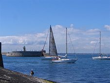
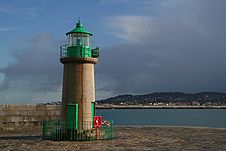 Lighthouse at the West Pier.
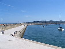
The harbour, one of the largest in the country, and base for a now limited car ferry route to the United Kingdom, is notable for its two granite piers. The East Pier is particularly popular with walkers, and was featured in the 1996 movie Michael Collins, where Liam Neeson (as Collins) and two of his co-stars are seen walking along a seaside promenade, which is actually the Dún Laoghaire East Pier. A band is seen playing on a bandstand in this movie scene, and this is the actual bandstand on the East Pier. The bandstand was restored to its original condition in 2010 by the Dún Laoghaire Harbour Company.[6]
It took 42 years to construct the harbour, from 1817 to 1859. The obelisk near the old ferryport terminal at the harbour commemorates the construction of this harbour.
A lighthouse was located at the end of the East Pier, while the new headquarters of the Commissioners of Irish Lights (the General Lighthouse Authority for Ireland) is located on Harbour Road.
South of the harbour is Scotsman's Bay, where there was a Victorian seaside amusement area, with walks, shelters and baths. The walks and shelters are largely intact but the Dún Laoghaire Baths have been derelict for many years. Plans for restoration of this area are much debated, and some of the more ambitious ideas have been highly controversial.
A traditional Victorian-style park, the People's Park, is located at the eastern end of George's Street, and including still-functioning tea rooms.
At least one traditional "cabman's shelter" survives – these were small buildings built for the drivers of horse-drawn taxis.
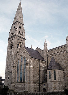
Community facilities include the Boylan Community Centre, the Dún Laoghaire Scout Den, and a community information service in the tower building of St. Michael's Church.
Dún Laoghaire promenade.
Transport
Public transport
Dún Laoghaire is connected to central Dublin by the DART suburban railway, and is also a stop on the mainline rail service from Dublin to Wexford and Rosslare. The town is also served by a frequent bus service e.g. 7, 45a, 46a, 59, 111, and 75. Beside the railway station is the terminus of the 75 and the 46a, the most frequent and heavily used bus route in Dublin. The 746 bus route from the station terminus to Dublin Airport was discontinued in October 2010. Sandycove and Glasthule and Salthill and Monkstown also serve the area.
An Aircoach service links the area with Dublin Airport 24 hours a day with stops at County Hall and the Royal Marine Hotel.
Rail history
The Dublin and Kingstown Railway, constructed and opened in 1834, was the first ever railway in Ireland, built to standard gauge. This was followed by the Dalkey Atmospheric Railway, an extension of the D&K that opened in 1843 (also built to standard gauge), the first railway to have practical application of pneumatic power. In 1854, the Dublin, Wicklow and Wexford Railway took over both lines, converting both to Irish gauge and the latter to steam power, extending further south to Bray, Wicklow, and eventually Wexford and Waterford as the Dublin and South Eastern Railway. In 1925, the DSER was amalgamated into the Great Southern Railways company, which lasted until 1944 when the railway was merged into CIÉ. Electrification arrived in 1984, and the suburban service was re-branded as DART.
Ferry
The town has a ferry connection to Holyhead in Anglesey, Wales, one of Ireland's main sea links to Great Britain.
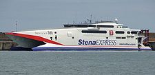
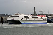
One sailing each way links Dún Laoghaire and Holyhead served by two Stena Line high speed ferries, the Stena Explorer and the Stena Lynx III.
Pedestrianisation
In the early 2000s, Lower George's Street underwent pedestrianisation, placing a ban on all general traffic with the exception of bus routes toward central Dublin. Bus routes coming along this road into Dún Laoghaire were re-routed along the sea front.[clarification needed] This restriction was reversed in late 2008. Many of the local residents[who?] felt that Dundrum Shopping Centre, which opened a mere 20 minutes drive from Dun Laoghaire was the major contributory factor to the "downturn" and were disappointed that the pedestrianisation was never implemented seriously by the local authorities.[citation needed] Dún Laoghaire Business Association attributed the downturn to high parking charges. They unsuccessfully called for these charges to be reduced to one euro per hour. (Dundrum charges two euro for three hours)[7]
Sports
Boating
Dún Laoghaire harbour is home to six yacht clubs. From north (West Pier) to south (East Pier) they are the Dún Laoghaire Motor Yacht Club, the Sailing in Dublin Club, the Royal Irish Yacht Club, the Royal St. George Yacht Club, the Royal Alfred Yacht Club, and the National Yacht Club. The Irish National Sailing School & Club, Ireland's largest sail training provider for adults and children alike is based at the foot of the West Pier.
The area to the north of the West Pier at Salthill Beach sees much windsurfing activity over the twelve months of the year.
St. Michael's Rowing Club, one of the longest-established members of the East Coast Rowing Council, has its roots in Dún Laoghaire harbour since the hobblers of the 18th and 19th centuries. The club itself has existed since the early 1920s and still resides in the Coal Harbour boat yard today. Members can regularly be seen rowing their traditional, clinker built skiffs around the harbour and Scotsman's Bay throughout the year.
Marina
The 500-berth marina is the largest in the country, and opened in 2001 following resistance for over 15 years by a group led by the late John de Courcy Ireland, the maritime historian. Following his death in April 2006, a 240-berth extension, involving an investment of €3 million, was approved in June 2006 by An Bord Pleanála; the project was completed in April 2007.
Golf
The town had a golf club from 1909 to 2007, but its members agreed to sell the course to housing developers and move to Ballyman Road, near Enniskerry in County Wicklow. The move occurred on 1 August 2007, to a purpose-built 96-acre (390,000 m2) site, with spectacular views over the Wicklow countryside including the Sugarloaf mountain. The new course is one of the finest in the Dublin area, with some people dubbing the course "The D Club", in reference to Kildare's spectacular K Club.
Dun Laoghaire Golf Club’s 27-hole championship course has been designed by Hawtree to allow different combinations of the three nine-hole courses to be played. The championship courses played from the blue tees range from 6543 to 6281 metres, although with five sets of tees, the course provides an exhilarating challenge to both professional and club golfers alike.
The magnificent 5-star Clubhouse which incorporates a spectacular terrace with stunning panoramic views of the Wicklow Mountains has spacious locker, dining and bar facilities, meeting rooms and offices and is perfectly equipped to cater for any function.
It’s golf performance academy is one of Ireland’s leading teaching facilities and includes indoor swing studio, indoor putting studio, 13-bay driving range, dedicated pitching and chipping area, bunker area and gym. Dun Laoghaire Golf Club’s 27-hole championship course has been designed by Hawtree to allow different combinations of the three nine-hole courses to be played. The championship courses played from the blue tees range from 6543 to 6281 metres, although with five sets of tees, the course provides an exhilarating challenge to both professional and club golfers alike.
The magnificent 5-star Clubhouse which incorporates a spectacular terrace with stunning panoramic views of the Wicklow Mountains has spacious locker, dining and bar facilities, meeting rooms and offices and is perfectly equipped to cater for any function. It’s golf performance academy is one of Ireland’s leading teaching facilities and includes indoor swing studio, indoor putting studio, 13-bay driving range, dedicated pitching and chipping area, bunker area and gym. http://www.dunlaoghairegolfclub.ie/
Education
The Dún Laoghaire area is home to four third level education establishments; Senior College Dún Laoghaire in the town centre, which will shortly move to Blackrock;[8] Dún Laoghaire Institute of Art, Design and Technology, Dún Laoghaire College of Further Education on Cumberland Street and Sallynoggin College of Further Education.
The main Primary School in Dún Laoghaire is Dominican Primary School Dún Laoghaire
Dún Laoghaire has seen several of its secondary schools close in the past two decades, due to population shifts to outlying areas. Three schools which closed are, CBS Eblana Avenue, founded in 1856 and closed in 1992 (although the fee paying school C.B.C. Monkstown which relocated from Eblana continues to this day), the Dominican Convent girls' school, which closed a year earlier in 1991 and Presentation College Glasthule founded in 1902, closed in 2007.
Located in Monkstown Farm, Holy Family National School is a primary school in the area. Also METNS (Monkstown Educate Together National School) located on Kill Avenue, Dún Laoghaire.
Shopping and business
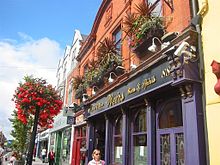
George's Street, the town's main shopping thoroughfare
Dún Laoghaire has one main shopping street, George's Street, as well as two shopping centres: the Dún Laoghaire Shopping Centre and Bloomfields, the former dating from 1977. Recent years have seen some commercial development of the land around the George's Street area, including, notably, the old Pavilion Cinema and Theatre site opposite the town hall. There is a regular antiques fair held bi-monthly, on Sundays in the Royal Marine Hotel, near the harbour, and a weekly farmers market held in the People's Park on Sundays.
The town has a wide range of eating places and public houses, as well as more than one hundred other retail businesses, including famous high street shops such as Marks and Spencer, Penneys and Dunnes Stores.
The town is home to the head office of Ireland's largest supermarket operator, Tesco Ireland, whose stores previously anchored both major shopping centres in the town. But the one in Dún Laoghaire Shopping Centre which had been in operation since 1977, closed in May 2011 leaving only the one in Bloomfields. [9]
Dún Laoghaire also holds other company headquarters, such as those of Bord Iascaigh Mhara and Lionbridge Ireland.
There is an active Business Association, and a local Chamber of Commerce.
Health
Dún Laoghaire is home to St. Michael's Hospital as well as a number of private clinics, therapists and general practitioners.
Tourism
Much of the town's early growth came from visitors from Dublin, and today there is one large hotel, heavily refurbished in 2007, the Royal Marine, along with several small hotels, and a number of bed-and-breakfasts.
Bars & Night Life
Dún Laoghaire boasts 11 bars and 4 night clubs, mostly centred along the main street Georges Street Upper. They include “traditional Irish bars” like Farrell's, Walter's, Lion Bar, Weir's, McKenna's & Dunphy's
Culture
Dún Laoghaire has associations with many leading cultural figures, most notably James Joyce and Samuel Beckett.
Joyce's stay with Oliver St. John Gogarty in a Martello tower in nearby Sandycove he later immortalised in the opening chapter of Ulysses. This tower, known as the James Joyce Tower, is in nearby Sandycove. It contains a small museum.
Samuel Beckett came from nearby Foxrock and is said to have experienced an artistic epiphany, alluded to in his play Krapp's Last Tape, while sitting on the end of one of Dún Laoghaire's piers. A bronze plaque marks the spot.
The famed black equestrian and circus owner, Pablo Fanque, immortalized in The Beatles' song Being for the Benefit of Mr. Kite! performed here for one week during a long engagement in Dublin, in 1850.[10]
In August 1991, Seattle grunge band Nirvana played at the The Top Hat.
Dún Laoghaire was previously home to the Festival Of World Cultures, a three day festival dedicated to music from all corners of the globe. It was one of the largest music festivals in Ireland attracting over a quarter of a million visitors to the town over a weekend in August. For nine years (2001-2010), the festival was a huge success, but unfortunately it was decided by Dún Laoghaire Rathdown County Council to stop hosting the festival as in 2010 there was large losses.[11]
A new purpose built theatre, the Pavilion, opened its doors in 2000. Built on the site of the 1903 'Kingstown Pavilion', it serves as the Municipal Theatre for Dún Laoghaire-Rathdown, and is a host venue for a number of important festivals including the International Puppet Festival, and, recently, the Dublin Theatre Festival.
St Michael's Church is home to the longest-running series of organ concerts in Ireland, featuring the famous 1974 organ by Rieger Orgelbau which is the only organ of its type in Ireland.
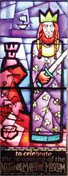
The National Maritime Museum of Ireland is housed in "Mariners' Church", which formerly served the British Navy, and is situated in the town centre, alongside a spiral walk, pond and public bowling ground. The museum is currently undergoing major refurbishment[12] and is due to reopen in 2011.
A Carnegie library, with a modern extension, is located on Library Road, and hosts the county library headquarters. A new central library will be built alongside the maritime museum.[13]
There is a tiny oratory (4m x 6m). described as a "gem of Celtic Renaissance Art".[14]
People
see Category:People from Dún Laoghaire
See also
References
- ^ Census for post 1821 figures.
- ^ http://www.histpop.org
- ^ http://www.nisranew.nisra.gov.uk/census
- ^ Lee, JJ (1981). "On the accuracy of the Pre-famine Irish censuses". In Goldstrom, J. M.; Clarkson, L. A.. Irish Population, Economy, and Society: Essays in Honour of the Late K. H. Connell. Oxford, England: Clarendon Press.
- ^ Mokyr, Joel; O Grada, Cormac (November). "New Developments in Irish Population History, 1700-1850". The Economic History Review Volume 37 (Issue 4): 473–488. doi:10.1111/j.1468-0289.1984.tb00344.x. http://www3.interscience.wiley.com/journal/120035880/abstract
- ^ restored[1]
- ^ Dún Laoghaire Business (Dún Laoghaire: Dún Laoghaire Business Association). December 2009.
- ^ Senior College Dun Laoghaire's New Blackrock Campus
- ^ Tesco to close store in Dun Laoghaire centre - The Irish Times - Wednesday, May 11, 2011
- ^ The Freeman's Journal and Daily Commercial Appeal, 17 June 1850.
- ^ No Festival of World Cultures in 2011?
- ^ Maritime Institute of Ireland press release
- ^ Dún Laoghaire-Rathdown County Council – press release
- ^ "Heritage Week 2008 in Dún Laoghaire-Rathdown County". Dún Laoghaire-Rathdown County Council. http://www.dlrcoco.ie/heritage/week.htm. Retrieved 2009-05-22..
External links
- Dún Laoghaire Town - Official Site of EU Brand Project
- Dún Laoghaire-Rathdown County Council
- Dún Laoghaire Borough Historical Society
- Dún Laoghaire Harbour Company
- Dún Laoghaire Lifeboat Station
- Dún Laoghaire-Rathdown County Enterprise Board
- Festival of World Cultures
- History of the Holyhead to Dún Laoghaire ferry service
- Pavilion Theatre
- 8th Port Sea Scouts of Dun Laoaghaire
- Dun Laoaghaire Golf Club
- Dun Laoghaire School
- Virtual Tour of Dun Laoaghaire
Places in Dún Laoghaire–Rathdown County town: Dún Laoghaire Towns Dún Laoghaire · Glencullen · Shankill
Villages Ballinteer · Ballybrack · Blackrock · Booterstown · Cabinteely · Carrickmines · Cherrywood · Churchtown · Dalkey · Deansgrange · Dundrum · Foxrock · Goatstown · Glasthule · Glenageary · Johnstown · Killiney · Kilmacud · Kilternan · Leopardstown · Loughlinstown · Monkstown · Rathfarnham · Sandyford · Sandycove · Sallynoggin · Stepaside · Stillorgan
Category:Mountains and hills of County Dublin · Category:Rivers of County Dublin · Category:Geography of County Dublin Divisions of County Dublin, Ireland County seats: Dublin · Dún Laoghaire · Tallaght · Swords Cities Counties Districts See also Categories:- Dún Laoghaire
- Towns and villages in Dun Laoghaire-Rathdown
- Port cities and towns in the Republic of Ireland
- Irish Sea
- Marinas in Ireland
- County towns in the Republic of Ireland
- Articles on towns and villages in Ireland possibly missing Irish place names
Wikimedia Foundation. 2010.

