- Clontarf, Dublin
-
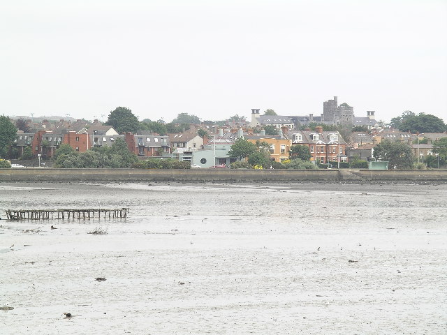
Clontarf
Cluain Tarbh— Town — 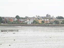 Location in Ireland
 Clontarf
Coordinates: 53°21′54″N 6°12′36″W / 53.365°N 6.21°WCoordinates: 53°21′54″N 6°12′36″W / 53.365°N 6.21°W Country Ireland Province Leinster County Dublin 3 Population (2006) - Urban 31,063 Time zone WET (UTC+0) - Summer (DST) IST (WEST) (UTC-1) Irish Grid Reference Clontarf (Irish: Cluain Tarbh) is a coastal suburb on the northside of Dublin, in Ireland. It is most famous for giving the name to the Battle of Clontarf in 1014, in which Brian Boru, High King of Ireland, defeated the Vikings of Dublin and their allies, the Irish of Leinster. This battle, which extended to districts over several miles, is seen as marking an end to the Irish-Viking Wars. The Irish version of the suburb name (Cluain Tarbh) literally means "The meadow of the bull", this literal translation explains the prevalence of the word "bull" in a number of location names within the suburb.
Clontarf lacks a single "village centre" but has a range of commercial facilities in several locations, mainly centred around Vernon Avenue. Clontarf adjoins Fairview, Marino, Killester, Artane and Raheny, and is in the postal district Dublin 3.
Contents
Access
Clontarf's sea front is served by the No. 130 Dublin Bus route, and the inland parts can be reached from buses on the Howth Road, such as the 29A, 31 series and 32 series. The area's historic railway station, on the Howth Road, closed many years ago, but a new railway station, Clontarf Road railway station, a stop on the Dublin Area Rapid Transit system, is located between Clontarf and Fairview.
Natural features and amenities
Clontarf lies on one side of the estuary of one of Dublin's three main rivers, the River Tolka, and the Naniken River reaches the sea at the Raheny end of the district, its mouth marking a civil parish boundary.
One of Dublin's largest parks, St Anne's Park, lies between Clontarf and Raheny.
The Bull Island, also shared with Raheny, is connected to Clontarf by an historic wooden bridge. While most of the island is city property, the (North) Bull Wall and breakwater, related road and path, and Bull (Wooden) Bridge belong to the Dublin Port Company, and are closed for a day each year to assert this. At the end of the breakwater is a statue of Our Lady, Star of the Sea (Realt na Mara), to watch over mariners and dockworkers.
Clontarf Island
There used to be an island, called Clontarf Island, off the coast of Clontarf near the mouth of the Tolka, as shown on maps such as that of John Rocque in 1753,[1] with a single dwelling, and at some periods (notably in the 19th century), bathing facilities. The island was also used as a refuge from plague in 1650. Construction work on the Great South Wall and Bull Wall in Dublin Port changed the flow of water in Dublin Bay, threatening its existence, though it was in fact eventually destroyed by a large storm in 1844.
History
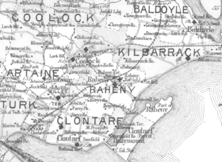 Clontarf and nearby districts, 1901
Following the defeat of the Vikings and the Leinstermen, Clontarf enjoyed relative peace for over 100 years until the arrival of the Normans in 1172. Shortly afterwards, Clontarf was granted to Adam de Pheypo, a follower of Strongbow. He built the first Clontarf Castle.
A settlement at Clontarf has been dated to at least the 12th century, and in the 19th century remains from earlier times were thought to have been found. Clontarf features on the 1598 map "A Modern Depiction of Ireland, One of the British Isles" by Abraham Ortelius as "Clantarfe".
The manor and church of Clontarf were held by the Templars and subsequently the Hospitallers, and there was a Holy Well in the area, near what is now The Stiles Road, until recent times (another spring, named for Brian Boroimhe, of uncertain age, still exists, on Castle Avenue near the sea).
A manor house and small associated village was located on the slight ridge overlooking the sea where the Clontarf Castle Hotel is now situated. The manor house was rebuilt many times, with the current hotel dating largely to the early 19th century. The tower house on the site is a 19th-century replica of the original Templar structure on the site. The adjoining ruined church is the old Church of Ireland parish church, dates to the mid-17th century and includes what may be the earliest use of red brick in Ireland.[citation needed]
Clontarf Castle was burned in 1641 by Cromwell's General, Charles Coote, apparently in revenge for the disloyalty of the then owner, George King. The castle, estate and district are then said to have been given by Cromwell to John Blackwell, who assigned his interest to John Vernon, Quartermaster-General of Cromwell's army in Ireland, although this is described in Lewis's Topographical Dictionary of 1837 as “conferred by the Crown on Admiral Vernon”. The Vernon family subsequently occupied the Castle for nearly three hundred years. See the entry on Clontarf Castle (After Cromwell) for further details.
In 1659, the population of Clontarf was 79.
Fishing, oyster-catching and farming remained the main occupations over the following centuries, with a major fish-curing industry at the Sheds, near the foot of Vernon Avenue (the Public House at the site still bears the name), around 1 km from the original village. In the 18th century, this developed into a secondary settlement, of fishermen and small farmers, living in basic cabins and with drying sheds for the fish. It is prominently marked on navigation maps for Dublin Bay dating to the 18th century. However, as with many such 'informal' settlements in Ireland, Clontarf Sheds became the site for a 19th-century Roman Catholic church - the Church of Ireland St. John's Church, and the Roman Catholic St. Anthony's are closer to the original settlement - and then outgrew the original village.
The 1837 Lewis report remarked that “ The land in this Parish is reported to be in the very highest state of cultivation...”
The 19th century
In the early 19th century, Clontarf had become a popular holiday resort for the citizens of Dublin, who came out from the city to enjoy bathing in the sea or in the hot and cold seawater baths erected by Mr. Brierly. A horse omnibus service from the city was started and Clontarf became a fashionable place to live - Samuel Lewis lists twenty-seven major houses, apart from Clontarf Castle, in which resided wealthy and important gentry.[2] The Confirmation list for 1824 includes four titled ladies – Lady Charlemont, Lady Caroline Clements, Lady Maria Caulfield and Lady Emily Caulfield.
Clontarf had an important role in the career of the prominent Irish nationalist leader Daniel O'Connell who sought to hold on this location, symbolic because of its association with the Battle of Clontarf in 1014, a mass meeting calling for repeal of the Act of Union. The meeting was banned by then-Prime Minister, Sir Robert Peel, and despite appeals from his supporters, O'Connell refused to defy the authorities and he called off the meeting, as he was unwilling to risk bloodshed.
A key arrival at Clontarf was Sir Benjamin Lee Guinness, son of Arthur Guinness II and his partner in running the brewery, who purchased various lands in Clontarf and Raheny, combining them to form St. Anne's Estate (the remnants of which form St Anne's Park).
By the late 19th century Clontarf was becoming urbanised, initially as a holiday resort for wealthy Dubliners, but rapidly as a suburb of the city. A tram line was laid along the coast, increasing activity in the area.
For a time, Clontarf was an Urban District incorporated in its own right but lost this formal status at the start of the 20th century. By the mid-20th century it was fully absorbed into the city and would now be considered part of the inner suburbs.
Religion
Clontarf today has two Roman Catholic parishes (for more see Parish of Clontarf (Roman Catholic)), a Church of Ireland Parish of Clontarf, a Presbyterian congregation and a Methodist parish.
Historically Clontarf has had a strong Protestant community for many years, with the Church of Ireland parish being one of the most populated Anglican parishes in the country up to the 1950s. In the 1911 census, 39% of the population of Clontarf were Protestant, 25% being Church of Ireland, 8.5% Presbyterian and 5.5% Methodist. Relations between all the faith communities have always been good in Clontarf and mixed marriages were part of life even in 1911.
Sport and social organisations
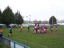 Rugby and cricket as well as GAA and football are popular in the suburb, here we see a Clontarf rugby team compete in red and blue stripes (colours shared by various Clontarf sporting organisations), with Clontarf cricket club in the background
Clontarf has many clubs whose members take part in sporting activities, including rugby, football, golf, cricket, sailing and Gaelic games.
Clontarf has a strong rugby club, their senior XV reaching two all Ireland league finals under former coach Phil Werahiko. The Clontarf Cricket Club Ground, based at the same premises as the rugby club, was the host for the final of the 2005 ICC Trophy cricket tournament. It has hosted various cricket internationals, most recently against the Australia in the summer of 2010, and is the home ground of the Ireland cricket team in the Republic of Ireland. Ireland are due to play another ODI against England in August 2011 at the ground.[3]
The Clontarf Cricket Club senior 1st XI have won the Leinster Senior Cup in 2007 and 2008.[4]
The area also has two tennis clubs - Clontarf Lawn Tennis Club on Oulton Road and Clontarf Parish Lawn Tennis Club on Seafield Road, recently re-developed and attached to the Church of Ireland parish. Tennis is also played at the private Westwood Club, on the border between Clontarf and Fairview.
Clontarf's privately-owned open-air seawater swimming pool, once a popular recreational destination with hot and cold baths, is now derelict, with various developments being considered.
The suburb also has numerous sporting facilities in St Anne's Park (which it shares with Raheny), as well as a range of non-sport amenities. These include an Arts Centre in the Red Stables, featuring artists' stores and studios, a coffee shop and markets on some weekends, along with a large rose garden which is located alongside the Gaelic Athletic Association pitches.
Clontarf is also home to the Dublin City Council Traffic Training Facility.
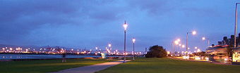 The new lights on the seafront
The seafront along Clontarf remains a highly popular spot for runners, walkers and cyclists and features an Easter Island Moai replica statue, a diplomatic gift, which is located just across the road from a local pub.
The Clontarf Scout Troop was established in 1931. Clontarf also has two Boys Brigade companies - the 39th, attached to Clontarf Church of Ireland, and the 12th, attached to the Presbyterian parish, and a Girls Brigade company (5th Company Clontarf Presbyterian) attached to Clontarf & Scots Presbyterian Church. This company was 100 years old in 2008 and was the first active company in the world to reach this age.
There is no current local newspaper but past journals included "Clontarf's Eye."
Schools
Local primary schools are Belgrove National School (NS), Greenlanes NS (Church of Ireland) and Howth Road Mixed NS (Presbyterian).
At second level, the area is served by Mount Temple Comprehensive School, Holy Faith School (for girls) and, on the border with Raheny, St. Paul's College, Raheny (for boys). St. Joseph's CBS. Secondary School , Fairview, is near by and close to the Dart.
Special education facilities exist at the premises of the Central Remedial Clinic and the Irish Wheelchair Association.
Amenities
Clontarf is home to a wide range of businesses, many of which are members of the local Chamber of Commerce. There is a supermarket on Vernon Avenue, and there are, for example, a number of public houses, restaurants, convenience stores, bank branches, pharmacies and medical practitioners.
Clontarf is also home to the famous Central Remedial Clinic (whose swimming pool has some public access hours) and to the Incorporated Orthopaedic Hospital of Ireland (since 1876), as well as a major centre of the Irish Wheelchair Association.
Governance and Representation
Clontarf is in the jurisdiction of Dublin City Council. It is a civil parish comprising many townlands.
Clontarf is in the Dublin North Central Dáil constituency and is one of the main components of the Clontarf Local Electoral Area for City Council elections.
Locality
Within Clontarf is the area known as Dollymount, formed in the 19th century, which gave its name to the beach on North Bull Island.
Points of note
Clontarf was the original home of the Grove Social Club disco which ran from 1967 to 1997. It started in 1967 in Mount Prospect Avenue in Clontarf, Belgrove Football Club (from which the club got its name). It moved to St. Pauls College, Sybil Hill Road, Raheny, in 1975 when the old pavilion was burnt down.
Along the coastal promenade, there is a circular rain shelter, which forms a cap over a former lead mine, which ran out under the shallow waters of the bay, as recorded in Cosgrave's "North Dublin"; it was closed due to persistent flooding.
Famous People
Bram Stoker, author of Dracula, was born at 15 Marino Crescent.
Arthur Edward Guinness, 1st Baron Ardilaun, of Guinness brewing fame, was born in St. Anne's House (the house lies in the Clontarf part of the estate, while the majority of the park is in Raheny), as was his elder brother Edward Cecil Guinness, 1st Earl of Iveagh.
Brian O'Driscoll, the current Ireland Rugby captain.
Film Director Neil Jordan (although he was born in Rosses Point, Co, Sligo).
Gerry Ryan, RTE 2fm DJ.
Joe Duffy, also of RTÉ.
Ray Kennedy (journalist), RTÉ journalist & newscaster.
Irish Rugby International Cian Healy is a proud resident.
PJ Gallagher (comedian)
Actor Don Wycherley
Actress and comedienne Maureen Potter lived in Fairview and Clontarf until her death in 2004. She is buried in St John the Baptist's cemetery on Castle Avenue. The inscription on her gravestone reads "In Loving Memory...Super Trouper".[5]
Prionnsias O'Duinn[6] Conductor for RTE Concert Orchestra and National Symphony Orchestra of Ecuador [7]
Current Dublin Lord Mayor Gery Breen.
Actress Maria Doyle was born in Clontarf on 25 September 1964.
Bank of Ireland's Chief Executive, Richie Boucher.
Fiddler Paddy Glackin
When Erwin Schrödinger moved to Dublin, he lived in Clontarf, on Castle Avenue.
Mezzo-Soprano Bernadette Greevy.
Academic Declan Kiberd.
Actor, singer and television presenter Bryan Smyth.
Hollywood actors Barry Fitzgerald (real name William Shields) and his brother, Arthur Shields, lived at no.13 Vernon Avenue.
Professional golfer Christy O'Connor Snr.
Aid worker, Sharon Commins who was kidnapped in Sudan in July 2009 was born and lived in Clontarf.
References and footnotes
- ^ The Neighbourhood of Dublin, Weston St. John Joyce, 1920
- ^ Among them were Thomas Gresham, founder of the Gresham Hotel and W.C. Colville, owner of major property holdings in the centre of Dublin
- ^ "Ireland international cricket grounds: Castle Avenue". http://www.cricketeurope4.net/CRICKETEUROPE/DATABASE/GROUNDS/IRELAND/clontarf.shtml. Retrieved on 17 December 2008.
- ^ "Clontarf Cricket Club". http://www.clontarfcricket.com. Retrieved on 17 December 2008.
- ^ "Maureen Potter dies aged 79". RTE.ie. http://www.rte.ie/news/2004/0407/potter.html. Retrieved on 17 December 2008.
- ^ www.imdb.com Retrieved on 22 May 2009
- ^ www.clssicsonline.com Retrieved on 22 May 2009
See also
External links
Categories:- Untranslated Irish place names
- Clontarf, Dublin
- Towns and villages in County Dublin


Wikimedia Foundation. 2010.