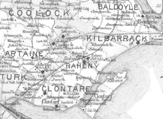
- Coolock
-
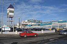 Northside Shopping Centre, Coolock, Dublin
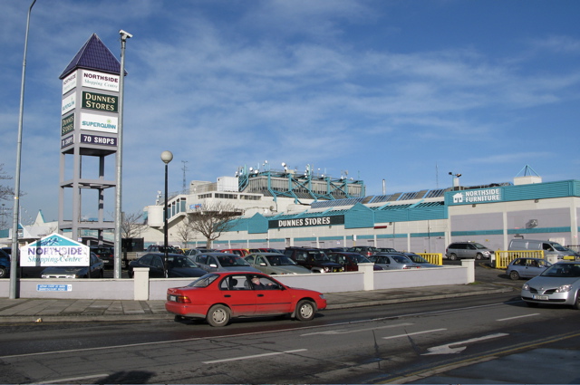
Coolock (Irish: An Chúlóg, meaning "The Little Corner") is a large suburban area, centred on a village, on Dublin city's Northside in Ireland. Coolock is crossed by the Santry River, a prominent feature in the middle of the district, with a linear park and ponds. The Coolock suburban area encompasses parts of three Dublin postal districts: Dublin 5, Dublin 13 and Dublin 17.
The civil parish of Coolock takes in the land between the Tonlegee Road (as far as Donaghmede) and the Malahide Road, as well as the lands on either side of the Malahide Road between Darndale and Artane, and the lands either side of the Oscar Traynor Road on the approach to Santry.
Coolock is also the name of the barony which accounts for most of north Dublin city, from the coast in to the Phoenix Park, and stretching north as far as to Swords.
Contents
History
Coolock has a history dating back over 3,500 years – a bronze-age burial site in the area dates back to 1500 BC. The settlement grew up around a small early-Christian church. A Catholic church, St. John's, was later built in the area (see Parish of Coolock (Roman Catholic) and Parish of Coolock (Church of Ireland) for more). The feudal barony of Coolock was granted in 1199 by Henry II to the Archbishop of Dublin.
Coolock remained a small village until the 1950s, when it began to be developed as part of Dublin's suburbs, with lands around the village being further developed over time, notably Bonnybrook and Kilmore West, between which a new centre to the area formed. At one time the old village was on the Malahide Road but that road was diverted and now passes slightly to the east of the village; in the meantime, a secondary hamlet, Newtown Coolock, developed further north.
Later again, lands in the north of Coolock were developed to form the new districts of Darndale and Priorswood, Dublin.
Famous historical figures linked to the area included Henry Grattan of Belcamp Park, and the novelist Charles Lever.
Location / Nature
 Coolock (most of) and areas to south and east
Coolock lies at the centre of majority working class Northside suburbs such as Kilbarrack, Donaghmede and the Edenmore part of Raheny, and itself includes localities such as Ayrfield, Bonnybrook, Darndale, Priorswood, Greencastle and Kilmore West. As with other large suburban areas, such as Tallaght or Swords, there is no legal definition for Coolock, and so no definitive population figures, but it is one of Dublin's largest residential areas.
The majority of Coolock, excluding Ayrfield, was built-up by the then city authority, Dublin Corporation, as part of a programme of phased inner city slum clearance (between, roughly, 1952 and 1987)[citation needed]. Dublin City Council calculates[citation needed] that addresses containing "Coolock" comprise the largest stock of local authority houses within its jurisdiction and the area is central to the linear range of local authority building that took place during between the 1960s and the 1980s across Dublin's Northside - i.e. Ballymun including Poppintree, Kilmore, Coolock, Edenmore, Kilbarrack and Donaghmede.
The permanent Traveller halting site estates (which differ in layout to traditional halting sites) of Cara Park and Dominick Park, found in the Belcamp area (along the N32) are among the largest halting site facilities provided by local authorities in Ireland. They contain an adult education centre and pre-school facilities for the local Traveller population, both located beside Dominick Park. At least one smaller, more traditional, Traveller settlement is found in the area, close to the Clare Hall Shopping Centre.
Localities
- Ayrfield is an area beginning on the north side of the Tonlegee Road, within the Dublin 13 postal code, opposite Edenmore, and near Donaghmede and Darndale, containing several estates such as Rathvale, Limewood, Millbrook, Slademore and Ard na Greine. Ayrfield has one primary school, St. Pauls Junior and Senior National School, and opposite the school is St. Paul's Roman Catholic Church. The main access road, Blunden Drive, is the home of Ayrfield Credit Union, Ayrfield Community Centre and O'Tooles GAC clubhouse and playing pitches. It is also home to Ayrfield United F.C. which has pitches beside the credit union.
- Belcamp, a housing estate beside Darndale.
- Bonnybrook, a locality within the core of Coolock, above the original village, site of the main shopping centre, and with its own Catholic church and primary school.
- Clonshaugh, (now in Dublin 17) stretching from the large Clonshaugh Industrial Estate opposite Kilmore all the way to the AUL, close to Baskin Lane. This includes Riverside, a housing estate at the side of the Santry River, with over 500 residents, first described as being in Santry, but with the postal district changed from Dublin 5 (old main Coolock code) to Dublin 17, and Newbury, situated behind Riverside, accessed from the Clonshaugh Road.
- Darndale, built as a range of social housing estates, east of Clonshaugh and west of Clare Hall. It comprises the estates of Buttercup, Marigold, Primrose Grove, Snowdrop Walk and Tulip Court.
- Greencastle, a locality within the core of Coolock, above the original village.
- Kilmore as a whole is a large area west of the Malahide road and east of the M1, where Coolock meets Artane and Beaumont; of this, Kilmore West is entirely within Coolock, and includes the sub-locality of Cromcastle, which features numorous multi-storey council flat blocks in the same style as blocks in kilbarrack.
- Priorswood, a small, densely populated locality found between Darndale and Clonshaugh, comprising the housing estates of Moatview, Fairfield and Ferrycarrig.
- St. Brendan's Estate, located across the Malahide Road from Coolock village proper, and comprising St. Brendan's Drive, Avenue & Park, Moatfield and Dunree Park.[1]
Religion
Coolock has given its name to religious divisions over a long period, and the primary historical ones are discussed at Parish of Coolock (Roman Catholic), and (from the Act of Supremacy), Parish of Coolock (Church of Ireland). Both Catholic (multiple) and Church of Ireland buildings stand within the area today. In the Catholic divisions, additional parishes today include Bonnybrook and Ayrfield (encompassing the Greenwood estate).
Education
- Chanel College, a large secondary school and adult education source, founded in 1955
- The Donahies Community School, a large secondary school and adult education source, founded in 1977
- Colaiste Dhulaigh, the largest secondary school in Coolock, located beside Northside Shopping Centre. Colasite Dhulaigh also provides third level courses (FETAC).
- St. Pauls Junior and Senior National School, Ayrfield
- St. Francis, Priorswood
Amenities
- Santry River Linear Park
- The Stardust Memorial Garden which is dedicated to the 48 people who lost their lives in the Stardust nightclub.
Coolock is also a centre of local government activity, with a Dublin City Council major centre, NEAR FM community radio station, Health Services Executive centre and recycling centre.
Businesses and retail facilities
- Northside Shopping Centre, Ireland's first covered shopping centre, situated near the northern fringe of the M50, with more than 70 outlets
- Coolock Industrial Estate, with both manufacturing and retail facilities
- Clonshaugh Industrial Estate, with a range of medium and large businesses
- The main distribution centre of Crown Paints, formerly Akzo Nobel, is located on the Malahide Road
- Headquarters of Cadbury Ireland, whose grounds include a prehistoric monument and a pitch and putt course
- Former headquarters of Chivers, which closed in 2008
- Formerly, Tayto Crisps, Ireland's largest factory for potato crisps, which closed in 2005
Clare Hall
The estate of Clare Hall, which lies between Coolock and Donaghmede, includes a small shopping precinct, and adjacent is a Tesco-owned centre which is now called Clare Hall Shopping Centre, and also features a petrol station and a large fitness club and swimming facility.
Organisations
- Leinster Fish Keepeing Society
- Parnells GAA club
- Coolock Town Football Club
- St Columban's Boys Football Club
- Beechlawn Rovers Football Club[citation needed]
- Chanel SCC FC play their home matches at Chanel College
- Priorswood F.C
- Clarehall Celtic Football Club
- St Francis Moatview FC
- Coolock and District Racing Pigeon and Social Club (formerly Darndale Racing Pigeon Club), founded in the 1970s, based at Belcamp[2]
- Kilmore Boys F.C.
- O'Tooles GAA Club, Ayrfield
- Ayrfield United F.C.
- Beep Club[citation needed]
- F.A.C.T. School of Performing Arts
Popular culture
Film & television
The Darndale area was featured extensively during location shooting for the 1991 film The Commitments, directed by Alan Parker and starring a mainly unknown cast at the time [2].
Transport
Coolock, which is not crossed by any rail systems, is serviced by main roads, including the N32 and Oscar Traynor Roads which link to the M1, and by the following Dublin Bus routes:
- 17A Kilbarrack to Finglas (Mellowes Road)
- 27 Talbot Street to Clare Hall Avenue
- 27B Eden Quay to Santry via Ballyshannon Ave (bus makes a 10 minute stop at Ballyshannon Ave, former departure point)
- 27C Leeson Street Bridge to Clare Hall Avenue
- 27X Belfield (U.C.D) to Clare Hall Avenue
- 42 Lower Abbey Street to Malahide (Coast Road) or Portmarnock (Sand's Hotel)
- 43 Lower Abbey Street to Swords Business Park
- 104 Clontarf DART Station to Finglas (Cappagh Hospital)
- 127 Leeson Street Bridge to Donaghmede Roundabout
- 129 Leeson Street Bridge to Baldoyle
References
See also
Categories:- Towns and villages in County Dublin
- Coolock

Wikimedia Foundation. 2010.