- Palmerstown
Infobox Irish Place
name = Palmerstown
gaeilge = Baile Phámar
map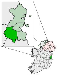
pin coords = left:31px; top:85px
north coord = 53.35
west coord = 6.379
irish grid = O082345
elevation = 17 [ [http://www.fallingrain.com/world/EI/7/Palmerston.html Maps, Weather, and Airports for Palmerston, Ireland ] ]
province =Leinster
county =South Dublin
town pop = 3929
census yr = 2006
web = www.sdcc.ie
|Palmerstown ( _ga. Baile Phámar) is a suburban area of
Dublin , Ireland located to the west of the city centre in the county ofSouth Dublin . The area is bordered to the west by Lucan, to the south byBallyfermot and to the east by the village ofChapelizod . Palmerstown is situated near theLiffey Valley Shopping Centre , which lies west of the M50 and takes its name from the picturesque Liffey valley to the north.Transport
Roads
The area is situated near a major junction of the M50 motorway (running from north to south) and N4 road (passing east to west). Prior to construction of the N4 (which now acts as the main arterial road for traffic entering and exiting Dublin city to and from the West) the Old Lucan Road was the main route into the city from the West, and it passes through Palmerstown village.
Bus
The main public transport node is in the form of bus stops running along both sides of the N4, with
Dublin Bus and other bus services running in and out of the city to Lucan,Celbridge ,Leixlip andMaynooth stopping here. There are also two other bus routes, one of which (the 26) travels to/from Cherryorchard/Dublin city centre via Palmerstown (Kennelsfort road) and the other (the 18) which travels to/from the Old Lucan Road to many of the southern suburbs of Dublin.Rail
Palmerstown railway station opened in November
1881 and finally closed on13 April 1940 . [cite web | title=Palmerstown station | work=Railscot - Irish Railways | url=http://www.railscot.co.uk/Ireland/Irish_railways.pdf | accessdate=2007-11-22|format=PDF]Local Areas
;Palmerstown VillageThe Village includes Robin Villas, and Hollyville. This area includes Stewart's Hospital, St. Philomenas church, the Parish Hall, the Palmerstown House pub and a number of shops, including a Centra convenience shop. The old village of Palmerstown contains several shops, The Palmerstown House, a local pub, the local church, St. Philomena's and [http://www.stewartshospital.com Stewarts Hospital] . The hospital, which provides care to people with
intellectual disabilities , overlooks the Liffey valley and is also an administrative centre for theHealth Service Executive (HSE), which is responsible for providing National health and personal social services.Stewart's Hospital also owns and operates a small school for people with intellectual disabilities, and has a Sports and Leisure centre for the general public that also hosts a summer camp every year.
;Old PalmerstownOld Palmerstown is a relative term referring to part of the area that was constructed mainly between 1955 and 1965. "The Cell" of Old Palmerstown is bounded by the Wheatfield and Kennelsfort roads, and by the N4. Manor Road, within Old Palmerstown, is the main local shopping district with newagents, hairdressers, takeaways, the local credit union and a doctor's surgery.
To the east of old Palmerstown is Glenaulin Park, home to St. Patricks GAA club and Palmerstown United F.C.
Mill Lane, a football ground opposite the river Liffey, is home to
Palmerstown Rangers F.C. ;Woodfarm AcresWoodfarm Acres takes its name from the Woodfarm cottages which previously existed on the site, a large housing estate built main during the 1970s now exists which is bounded by the M50 motorway and N4.
Adjacent to the Acres is another local shopping centre containing a local SuperValu, a bowling alley, an
Xtra-vision video store, diner and other shops. Access to the local cemetery is adjacent to this centre. The Silver Granite pub is located nearby as is a petrol station and "Pobalscoil Isolde", a public secondary school;OakcourtThe Oakcourt housing estate lies behind Pobalscoil and was constructed in the 1970s, with additional developments in the 1990s,
ee also
* List of towns and villages in Ireland
References
External links
* [http://maps.google.com/?ll=53.352447,-6.375375&spn=0.010759,0.029268&t=k/ Google Map of Palmerstown Area]
* [http://www.southdublinhistory.ie South Dublin County History]
* [http://www.southdublinimages.ie South Dublin County Images]
* [http://www.palmerstowncu.com Palmerstown Credit Union Website]
Wikimedia Foundation. 2010.