- M50 motorway (Ireland)
-
This article is about the M50 motorway in Ireland. For other M50 motorways, see M50 motorway.
M50 motorway

 Clickable image
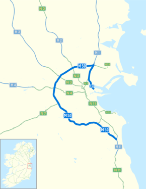
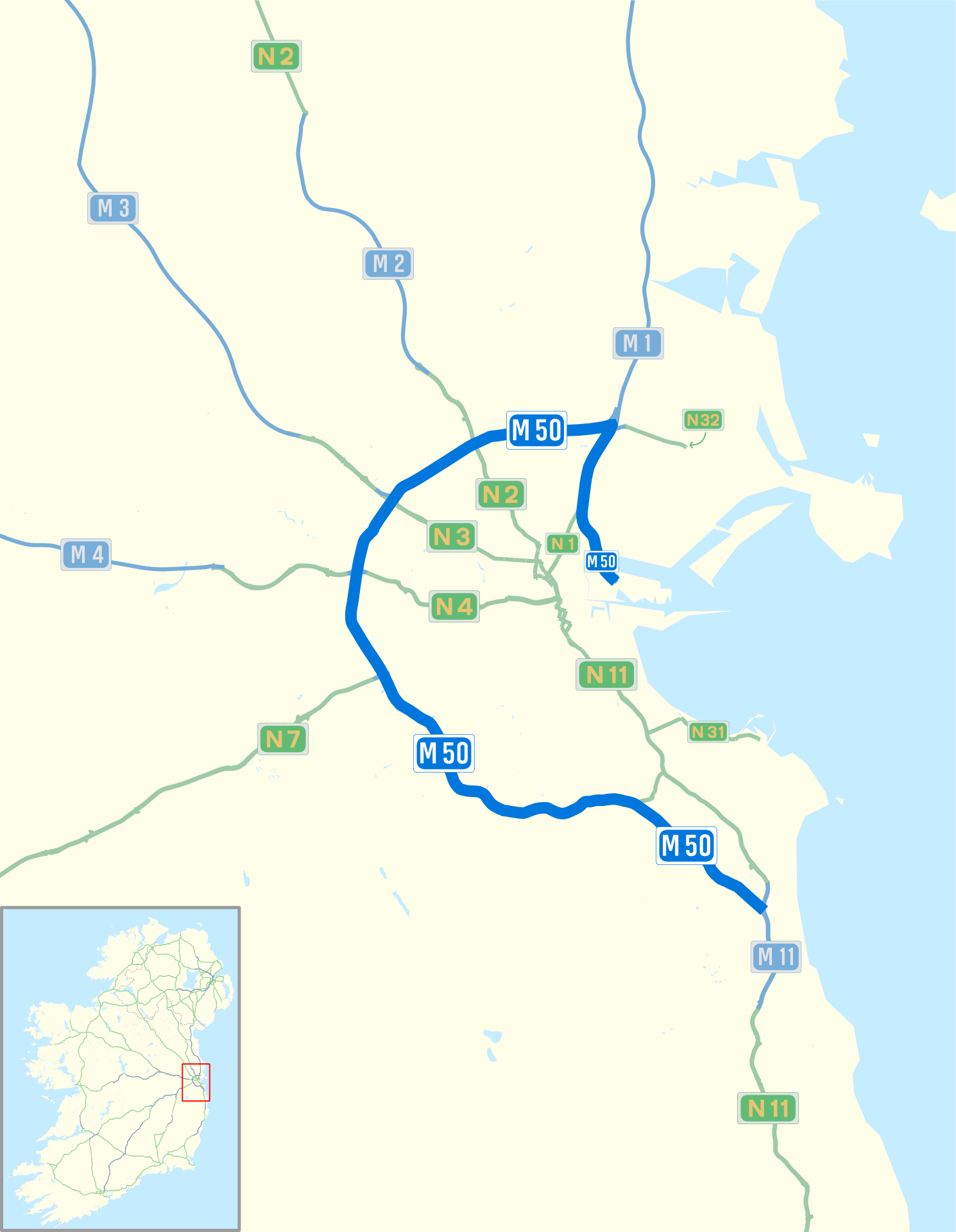
Route information Length: 45 km (28 mi) Existed: 1990 – present History: Completed in 2005 Major junctions From: Dublin Port 


To: Shankill Location Primary
destinations:Dublin, Finglas, Blanchardstown, Ballymount, Sandyford Road network The M50 motorway (Irish: Mótarbhealach M50) is a motorway in Ireland running in a C-shaped ring around the north-eastern, northern, western and southern sides of the capital city, Dublin. The northern end of the route is located at the entrance to the Dublin Port Tunnel. Anti-clockwise it heads northwest through the tunnel and then veers west at a junction with the M1 motorway. It crosses the dual West-Link toll bridges over the River Liffey in west Dublin, and forms a loop around the south-east of Dublin to meet the M11 route (running south to Wexford) at Shankill, County Dublin. Between Junctions 3 to 13 the road forms part of European route E01.
The M50 was first proposed in the Dublin Transportation Study of 1971. Construction began on the first part of the M50, the Western Parkway, in 1987. This section of the M50, between Junctions 6 (Blanchardstown) and 11 (Tallaght), opened to traffic in 1990. This was followed in 1996 by the Northern Cross section between Junctions 6 and 3 and the Southern Cross between Junctions 11 and 13 which opened in 2001. The completed M50 motorway was formally opened on 30 June 2005, and later the Dublin Port Tunnel, which was opened on 20 December 2006, was included as part of the route.
Work commenced in early 2006 on upgrading earlier sections of motorway. Many of the grade-separated signal-controlled roundabout interchanges were replaced with free-flowing junctions and the road from the M1 junction to Sandyford was widened to three lanes in each direction with a fourth auxiliary lane provided between junctions.
On Sunday 7th Feb 2010, the M50 Southern Cross was opened up to 3 lanes in each direction from J10 Ballymount to J14 Sandyford. This followed a week after the Northern Cross opened from J3 M1 to J6 N3. The M50 is now 3 lanes in each direction from J3 M1 to J14 Sandyford, with auxiliary lanes between all junctions from the M1 to Firhouse
Contents
Layout
 Upgraded section of M50
The M50 was originally planned to divert traffic traveling on National Primary Routes away from the city (a full bypass of Dublin). Due to urban expansion it now runs through Dublin's suburbs and serves a route for Dublin itself, connecting the suburbs.
All of the National Primary Routes leaving Dublin have junctions with the M50. The intersections were originally in the form of grade-separated signal-controlled roundabout junctions, not free-flowing interchanges. The M50 mainline itself was free-flow through all junctions. The other primary routes served are the N2 to Derry/Monaghan, N3 to Navan/Cavan/Northwest, N4/M4 to Galway/Sligo, N7/M7 (M8) to Cork/Limerick/Waterford, and the N11/M11 to Wexford. Additional junctions along the motorway serve other suburbs of Dublin such as Ballymun, Tallaght, Naas, Dundrum, Sandyford and Cherrywood.
Most of these interchanges were subject to high levels of traffic congestion, as was the former toll-plaza north of the West-Link bridge. The busier roundabout junctions were signal-controlled, with tailbacks extending for several kilometres at rush hour. The most infamous was the Red Cow roundabout junction with the N7, formerly dubbed the "Mad Cow Roundabout"[citation needed]. As well as being the junction of two of the busiest roads in the State, the Luas tram Red Line from Tallaght to the city centre used to cross two slip roads at-grade, before continuing city-bound in the median of the R110 (formerly N7). As part of the M50 upgrade works (see below), these at-grade crossings were removed, and on December 2008, the completely reconstructed interchange was open. This greatly reduced the congestion at the once-notorious traffic blackspot.
The roundabout at the N3 is also notable as the Royal Canal and the Dublin-Sligo railway line pass through its centre.
The original speed limit on the M50 was 70 mph (112 km/h) which was increased to 120 km/h when all speed limits in the Republic of Ireland became metric in 2005. The Southern Cross Route (the extension from Junction 12 to Junction 14) was given a lower limit of 60 mph (96 km/h) with a decimal limit of 100 km/h after 2005. This was because of its more undulating terrain, tighter and more frequent curves and resulting shorter sight lines. Because of the doubling of the number of running lanes along most of the route, which has shortened sight lines and increased lane changing, and due of the high number of junctions, the entire length of the route has (with the exception of the sections from Junction 1 to Junction 3 and Junction 14 to 17) the same speed limit, of 100 km/h, since it was completely upgraded (2007–10).
The section of the route which was previously the M1 from Junction 1 to Junction 3 (which is now the M50 up to the port tunnel) retains a speed limit of 80 km/h due to the closely packed junctions, and because of the high number and frequency of lane changes that are required among all manner of vehicles depending on their intended route. For example, traffic traveling Southbound on the M50 approaching the Dublin Port Tunnel must cross 2-3 lanes of traffic to avoid its portals. Whilst in the opposite direction, traffic exiting the tunnel must cross 3 lanes to continue on the M50 rather than progress onto the M1.
Exit list
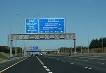
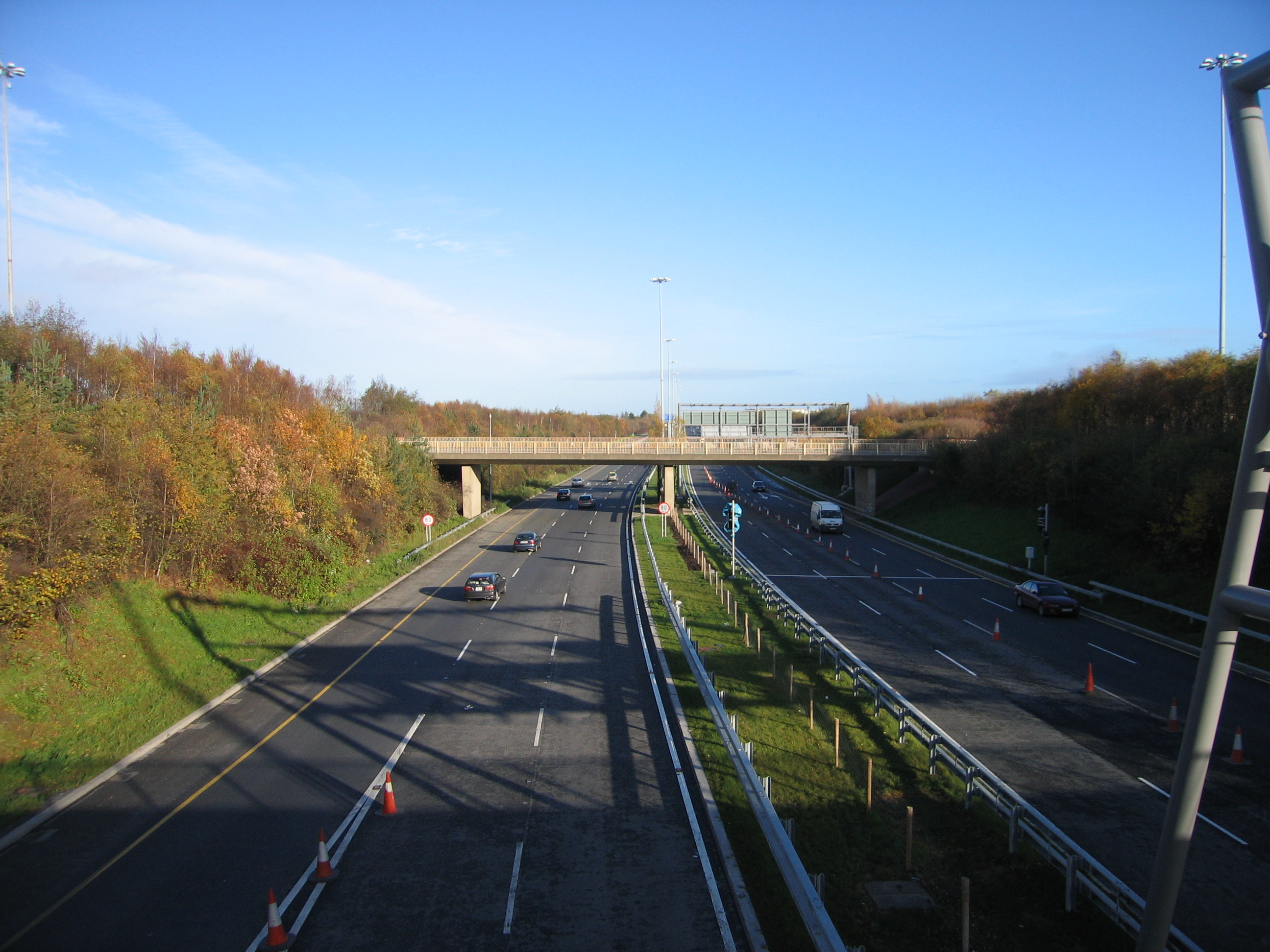
 M50 access ramp
 Between J1 and J2
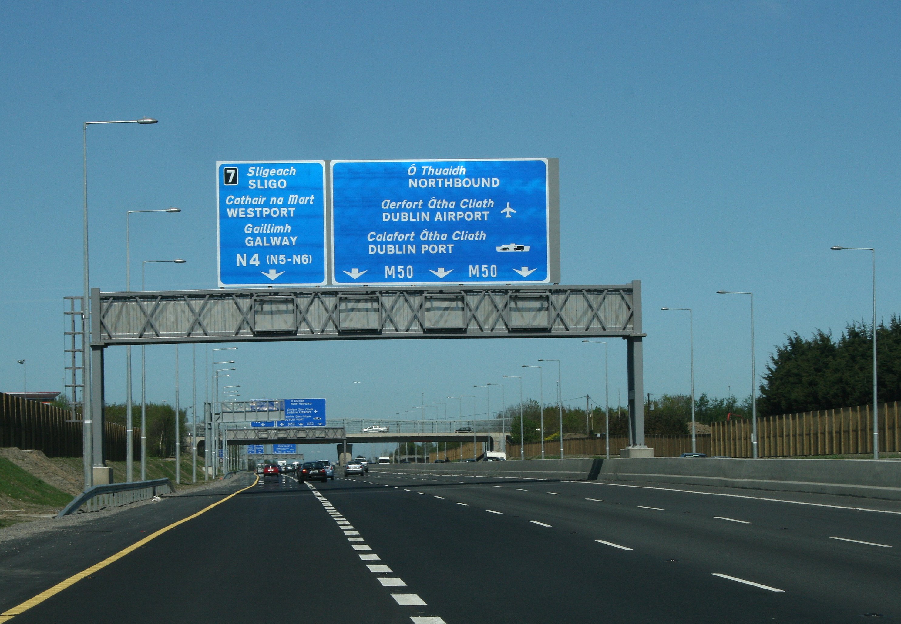
M50 Motorway Southbound Junction Northbound Start of motorway Terminals 1&2 1 End of motorway Dublin Port Terminals 1&2 Dublin Port Tunnel Toll (free for HGVs & buses) No exit 2 Coolock, Santry R104, City Centre N1 Non-Tunnel traffic Belfast, Dublin Airport M1, (Malahide) N32 (R107) 3 Belfast, Dublin Airport M1, (Malahide) N32 (R107) Ballymun R108 Ballymun Road 4 Ballymun R108 Ballymun Road, Santry Avenue , IKEA Finglas, Phibsboro, Dublin N2 (R135) 5 (Ashbourne), Derry N2 (R135) North Road , Finglas Road Cabra, City Centre N3 (Blanchardstown Bypass) Tyrrelstown Boulevard 6 Castleknock, Blanchardstown, The NORTH WEST N3 Navan Road , Phoenix Park Tyrrelstown Boulevard West-Link Toll bridge (now free flow) Palmerstown, Lucan, The WEST N4 (N5-M6) (Lucan Road) 7 Palmerstown, Lucan, The WEST N4 (N5-M6) Chapelizod Bypass, Con Colbert Road, Victoria Quay. Clondalkin, Naas, Crumlin R110, The SOUTH N7 (M8-M9) Naas Road, Monastery Road, Newlands Cross , Belgard Road, Luas Park n Ride , Kingswood Interchange , Citywest. 9 Clondalkin, Naas, Crumlin R110, The SOUTH N7 (M8-M9) Naas Road, Long Mile Road, Walkinstown Avenue. Ballymount R838 Parkhill Heights Boulevard 10 Ballymount R838 Parkhill Heights Boulevard Tallaght, Templeogue, Blessington, Tullow N81 Templeogue Road, Springfield Avenue. 11 Tallaght, Templeogue, Blessington, Tullow N81 Tallaght Bypass. Firhouse, Knocklyon, (R113) 12 Firhouse, Knocklyon, (R113) Dundrum (R826), Sandyford (R133), Ballinteer (R113) 13 Dundrum (R826), Sandyford, Dun Laoghaire N31 Dun Laoghaire N31 14 No exit Leopardstown / Carrickmines 15 Leopardstown / Carrickmines Loughlinstown, Shankill N11 (Northbound) 16 Loughlinstown / Cherrywood Motorway continues as M11 for The SOUTH EAST 17
(M11 exit 4)Shankill, Dublin M11 The South Eastern Motorway section, a radial route, was originally meant to be part of the M11. It curves away from the city centre and instead joins the N11 at junction 17 heading south. The next opportunity to exit the motorway at the Bray North exit of the M11.
There is no Junction 8, the junction number having being reserved for a potential extension of the M7 motorway from Lucan/Clondalkin to Naas. This is unlikely to be built given that the N7 Naas Road has been upgraded to dual three lane with at grade junctions converted to grade-separated interchanges or left-in, left-out (LILOs) junctions. However, it is an objective of South Dublin County Council to construct a new junction and use to it provide local access to the Cloverhill area of Palmerstown.[citation needed] This is also very unlikely to happen as the NRA have stated they are against the provision of new interchanges on the existing M50 as they are seen to contribute to traffic congestion on the route and undermine its function as a motorway.
Future plans
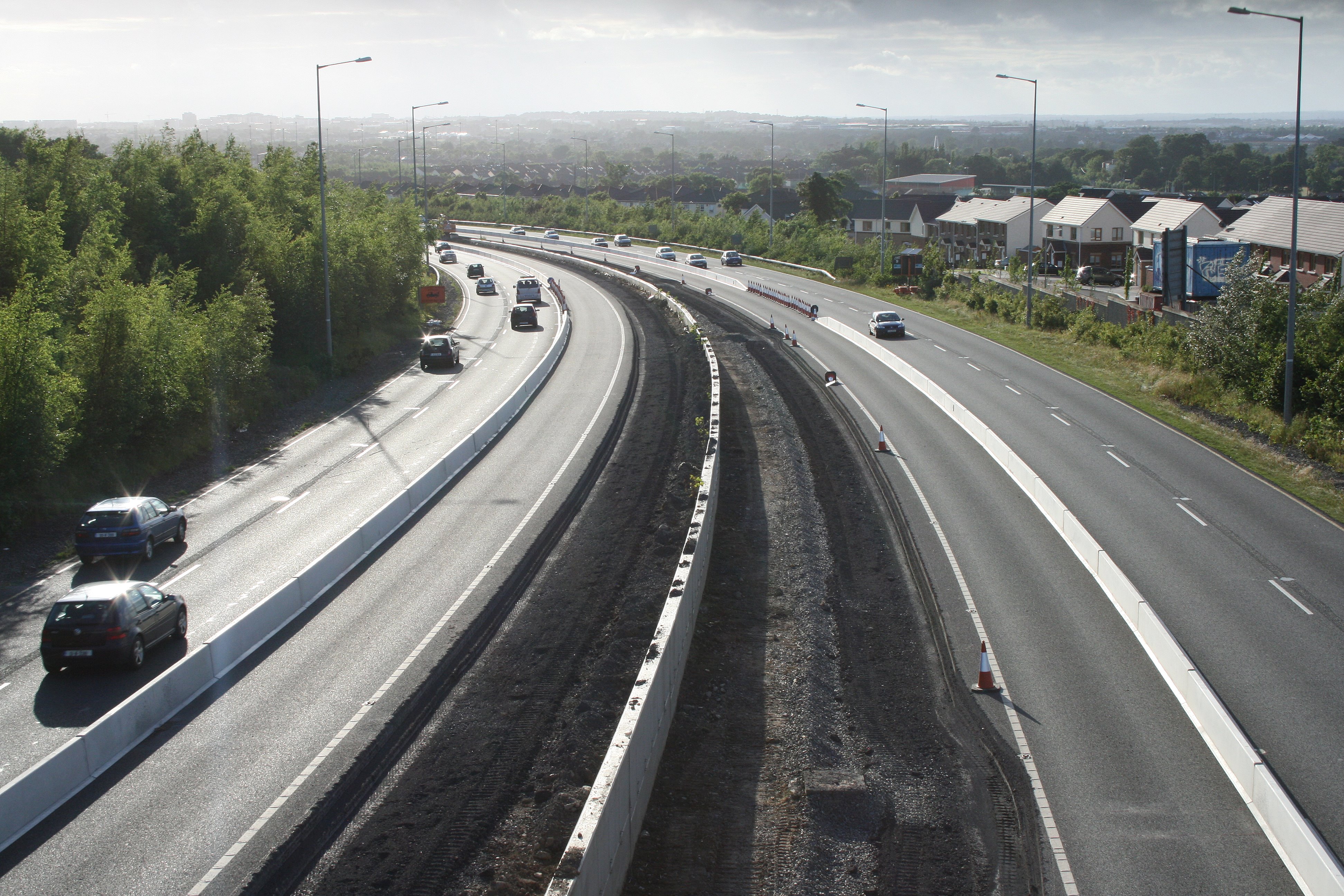
 M50 J13/J14 overlap
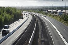 M50 widening (Southern Cross section between J12 and J13), looking west (northbound) in June 2008
Completion of Dublin's ring road by the building of an Eastern Bypass of the city has been proposed. This plan is controversial, as it would require a tunnel across Sandymount Strand to or possibly through Booterstown marsh bird sanctuary. A motorway reservation from Sandyford to Booterstown has been included in the Dun Laoghaire-Rathdown Development Plan, with space allowed for an interchange where it crosses the N11. The Dublin Port Tunnel, which opened on 20 December 2006, would form the northern half of the Eastern bypass.
Another outer orbital road has been proposed for the Dublin region. It will, if approved, run approximately from Drogheda via Navan, Trim and Kilcock towards Naas.
See also
- Roads in Ireland
- Motorways in Ireland
- National secondary road
- Regional road
- European route E01
External links
- Roads Act 1993 (Classification of National Roads) Order 2006 – Department of Transport
- M50 Motorway Upgrade
- Environmental Impact Statement on M50 Upgrade Scheme
- eFlow
References
Roads in Ireland Motorways National primary roads National secondary roads Regional roads (R101–R399) R101 · R102 · R103 · R104 · R105 · R106 · R107 · R108 · R109 · R110 · R111 · R112 · R113 · R114 · R115 · R116 · R117 · R118 · R119 · R120 · R121 · R122 · R123 · R124 · R125 · R126 · R127 · R128 · R129 · R130 · R131 · R132 · R133 · R134 · R135 · R136 · R148 · R149 · R150 · R151 · R152 · R153 · R154 · R155 · R156 · R157 · R158 · R159 · R160 · R161 · R162 · R163 · R164 · R165 · R166 · R167 · R168 · R169 · R170 · R171 · R172 · R173 · R174 · R175 · R176 · R177 · R178 · R179 · R180 · R181 · R182 · R183 · R184 · R185 · R186 · R187 · R188 · R189 · R190 · R191 · R192 · R193 · R194 · R195 · R196 · R197 · R198 · R199 · R200 · R201 · R202 · R203 · R204 · R205 · R206 · R207 · R208 · R209 · R210 · R211 · R212 · R213 · R214 · R229 · R230 · R231 · R232 · R233 · R234 · R235 · R236 · R237 · R238 · R239 · R240 · R241 · R242 · R243 · R244 · R245 · R246 · R247 · R248 · R249 · R250 · R251 · R252 · R253 · R254 · R255 · R256 · R257 · R258 · R259 · R260 · R261 · R262 · R263 · R264 · R265 · R266 · R267 · R268 · R277 · R278 · R279 · R280 · R281 · R282 · R283 · R284 · R285 · R286 · R287 · R288 · R289 · R290 · R291 · R292 · R293 · R294 · R295 · R296 · R297 · R298 · R299 · R310 · R311 · R312 · R313 · R314 · R315 · R316 · R317 · R318 · R319 · R320 · R321 · R322 · R323 · R324 · R325 · R326 · R327 · R328 · R329 · R330 · R331 · R332 · R333 · R334 · R335 · R336 · R337 · R338 · R339 · R340 · R341 · R342 · R343 · R344 · R345 · R346 · R347 · R348 · R349 · R350 · R351 · R352 · R353 · R355 · R356 · R357 · R358 · R359 · R360 · R361 · R362 · R363 · R364 · R365 · R366 · R367 · R368 · R369 · R370 · R371 · R372 · R373 · R374 · R375 · R376 · R377 · R378 · R379 · R389 · R390 · R391 · R392 · R393 · R394 · R395 · R396 · R397 · R398 · R399Regional roads (R400–R699) R400 · R401 · R402 · R403 · R404 · R405 · R406 · R407 · R408 · R409 · R410 · R411 · R412 · R413 · R414 · R415 · R416 · R417 · R418 · R419 · R420 · R421 · R422 · R423 · R424 · R425 · R426 · R427 · R428 · R429 · R430 · R431 · R432 · R433 · R434 · R435 · R436 · R437 · R438 · R439 · R440 · R441 · R442 · R443 · R444 · R445 · R446 · R448 · R449 · R458 · R459 · R460 · R461 · R462 · R463 · R464 · R465 · R466 · R467 · R468 · R469 · R470 · R471 · R472 · R473 · R474 · R475 · R476 · R477 · R478 · R479 · R480 · R481 · R482 · R483 · R484 · R485 · R486 · R487 · R488 · R489 · R490 · R491 · R492 · R493 · R494 · R495 · R496 · R497 · R498 · R499 · R500 · R501 · R502 · R503 · R504 · R505 · R506 · R507 · R509 · R510 · R511 · R512 · R513 · R514 · R515 · R516 · R517 · R518 · R519 · R520 · R521 · R522 · R523 · R524 · R525 · R526 · R527 · R548 · R549 · R550 · R551 · R552 · R553 · R554 · R555 · R556 · R557 · R558 · R559 · R560 · R561 · R563 · R564 · R565 · R566 · R567 · R568 · R569 · R570 · R571 · R572 · R573 · R574 · R575 · R576 · R577 · R578 · R579 · R580 · R581 · R582 · R583 · R584 · R585 · R586 · R587 · R588 · R589 · R590 · R591 · R592 · R593 · R594 · R595 · R596 · R597 · R598 · R599 · R600 · R601 · R602 · R603 · R604 · R605 · R606 · R607 · R608 · R609 · R610 · R611 · R612 · R613 · R614 · R615 · R616 · R617 · R618 · R619 · R620 · R621 · R622 · R623 · R624 · R626 · R627 · R628 · R629 · R630 · R631 · R632 · R633 · R634 · R635 · R637 · R638 · R639 · R659 · R660 · R661 · R662 · R663 · R664 · R665 · R666 · R667 · R668 · R669 · R670 · R671 · R672 · R673 · R674 · R675 · R676 · R677 · R678 · R679 · R680 · R681 · R682 · R683 · R684 · R685 · R686 · R687 · R688 · R689 · R690 · R691 · R692 · R693 · R694 · R695 · R696 · R697 · R698 · R699Regional roads (R700–R940) R700 · R701 · R702 · R703 · R704 · R705 · R706 · R707 · R708 · R709 · R710 · R724 · R725 · R726 · R727 · R729 · R730 · R731 · R733 · R734 · R735 · R736 · R737 · R738 · R739 · R740 · R741 · R742 · R743 · R744 · R745 · R746 · R747 · R748 · R749 · R750 · R751 · R752 · R753 · R754 · R755 · R756 · R757 · R758 · R759 · R760 · R761 · R762 · R763 · R764 · R765 · R766 · R767 · R768 · R769 · R770 · R772 · R773 · R774 · R801 · R802 · R803 · R804 · R805 · R806 · R807 · R808 · R809 · R810 · R811 · R812 · R813 · R814 · R815 · R816 · R817 · R818 · R819 · R820 · R821 · R822 · R824 · R825 · R826 · R827 · R828 · R829 · R830 · R831 · R833 · R834 · R835 · R836 · R837 · R838 · R839 · R840 · R841 · R842 · R843 · R846 · R847 · R848 · R849 · R851 · R852 · R853 · R854 · R855 · R857 · R858 · R859 · R860 · R863 · R864 · R865 · R866 · R867 · R868 · R870 · R871 · R873 · R874 · R875 · R876 · R877 · R880 · R883 · R884 · R885 · R886 · R887 · R888 · R889 · R890 · R891 · R895 · R896 · R898 · R899 · R900 · R901 · R902 · R903 · R904 · R906 · R907 · R908 · R909 · R910 · R911 · R913 · R914 · R915 · R916 · R917 · R918 · R919 · R920 · R921 · R922 · R923 · R924 · R925 · R926 · R927 · R928 · R929 · R930 · R931 · R932 · R933 · R934 · R935 · R936 · R937 · R940Transport in Dublin Air Rail Tram*Road Bus corridorsR101 · R102 · R103 · R104 · R105 · R106 · R107 · R108 · R109 · R110 · R111 · R112 · R113 · R114 · R115 · R116 · R117 · R118 · R119 · R120 · R121 · R122 · R123 · R124 · R125 · R126 · R127 · R128 · R129 · R130 · R131 · R132 · R133 · R134 · R135 · R136 · R148 · R156 · R403 · R445 · R761 · R810 · R817 · R821 · R822 · R824 · R825 · R826OtherWater CanalsPortsAgencies *=Tram systems no longer run. Information in parentheses shows the operator(s)Categories:- Motorways in the Republic of Ireland
- Roads in County Dublin
- Orbital roads


Wikimedia Foundation. 2010.