- National primary road
-
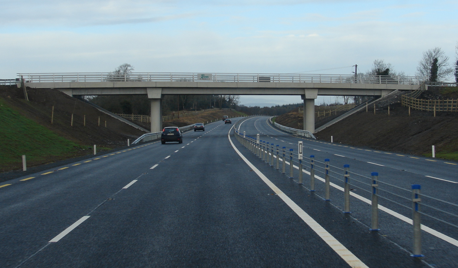
 Naas Road (N7), non-Motorway high-grade dual carriageway.
A national primary road (Irish: Bóthar príomha náisiúnta) is a road classification in the Republic of Ireland. National primary roads form the major routes between the major urban centres. There are over 2,700km of national primary roads[citation needed]. This category of road has the prefix "N" followed by one or two digits. By contrast, the motorway category has theprefix "M" followed by one or two digits.
Contents
Description
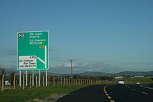
 Non-motorway National Route sign in Ireland.
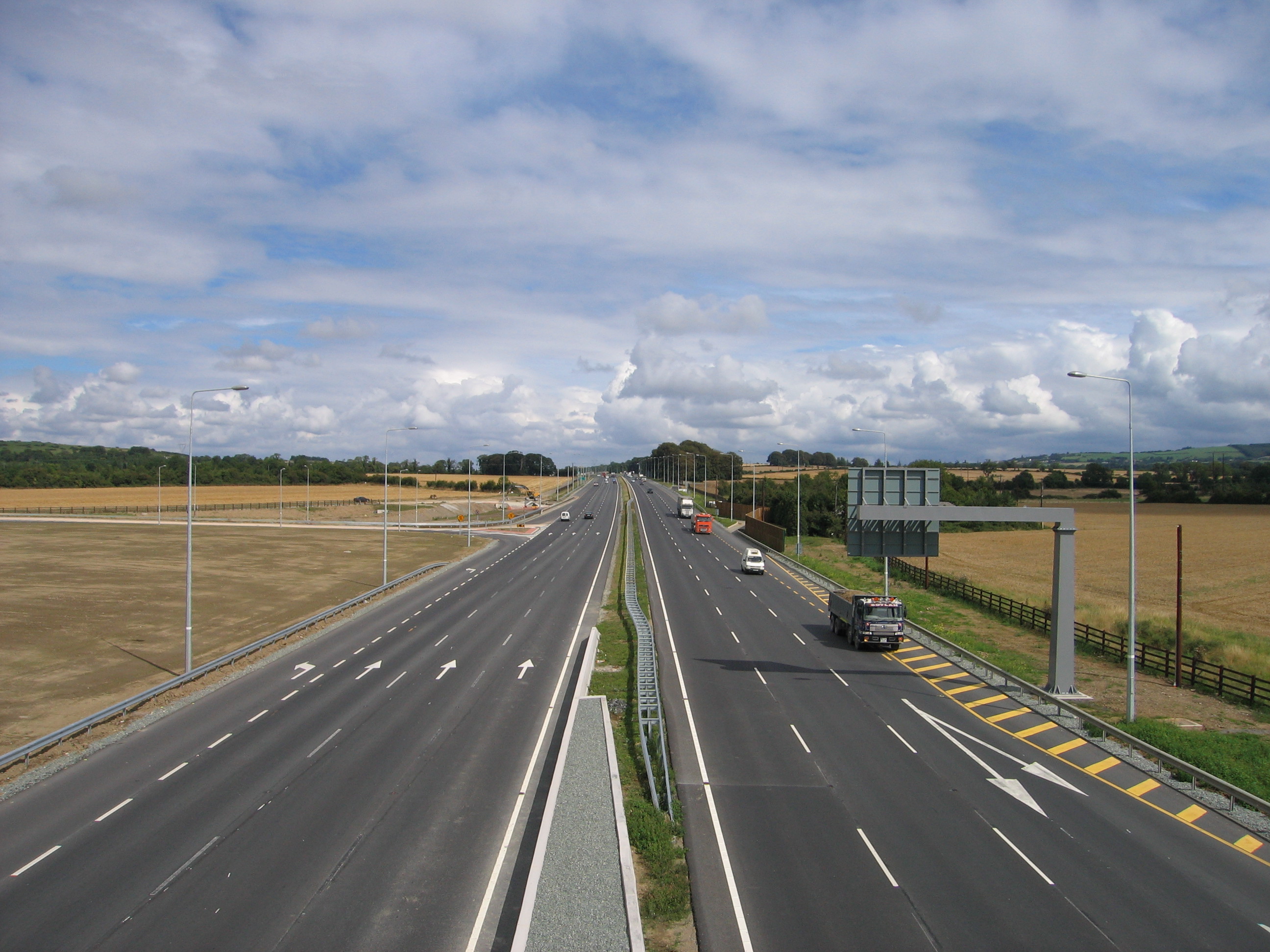
 2+2 section of the N4 (Dromod-Roosky bypass) in Co. Leitrim.
The routes numbered N1–N11 radiate anti-clockwise from Dublin, with those in the range N12–N26 being cross-country roads. Routes numbered N27–N31 are much shorter roads than the majority of the network: they link major pieces of infrastructure (such as ports and airports) to the network, while N32 and N33 are feeder routes to major motorways (the M50 and M1 respectively). National secondary roads (see next section) are numbered under the same scheme with higher numbers (from N51 on). On road signage, destinations served but not on the route in question are listed in brackets, with the connecting route also listed (see thumbnail). Directional road signs on national primary roads are usually in white text on a green background, with the road number in yellow. Signs for roads of different standard are shown using appropriately coloured patches according to a system derived from the UK's Guildford Rules.
Most national primary roads are of at least wide two lane standard, with sections within Greater Dublin and near the regional cities typically being at least dual-carriageway standard. There are however some narrow two-lane sections remaining.
Northern Ireland route sections (which are classified separately according to NI schemes) are in some cases included in a theoretical complete cross-border route – for example the N3 route, which re-enters the Republic. These are listed here in brackets for completeness (and are present on southern road signage).
Sections of some national primary roads form part of the European route (E-route) network. Sections of the N25, N11 and N1 roads form the Republic of Ireland part of route E1 (or E01); sections of the N7, N18 and N19 roads form part of route E20; the N8 forms part of route E201 and sections of the N25 form part of route E30. E-route numbers have recently been placed on some route confirmation signs on newer sections of some of these roads.
History
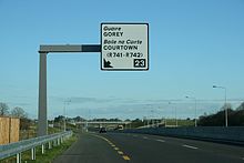
 N11 Exit sign.
From the 1920s through to 1977, Irish roads had been numbered under a system of Trunk Roads and link roads (see Trunk Roads in Ireland for details). The introduction of a National Route numbering system had been discussed since the late 1960s. Legislation to allow its introduction was passed in 1974: the Local Government (Roads and Motorways) Act 1974[1], which introduced the concepts of motorways and national roads into Irish law. The routes of the original 25 national primary roads were defined via Statutory Instrument (the Local Government (Roads and Motorways) Act, 1974 (Declaration of National Roads) Order, 1977[2]) in 1977 and the new numbers began to appear on road signs shortly thereafter, with the N4 road and N6 road the first to be signed. The first motorway, the M7 Naas bypass, opened in 1983.
Since the introduction of the National Route numbering system, the system has remained relatively unchanged in its overall design, although as new bypasses open the various routes themselves have undergone changes. The legislative basis for the system changed in 1993 with the Roads Act 1993.[3] This act introduced a major change: a new body, the National Roads Authority (NRA), was set up to manage the national road network. It also made motorways integral parts of national routes (previously they had been a separate classification) and introduced the new classifications of Regional road and local road. In 1994, three national secondary roads (N57, N64, N79) were reclassified as national primary roads and subsequently renumbered (N57 to N26, N64 to part N18, N79 to N30) while a section of the N60 between Castlebar and Westport in Co. Mayo was reclassified as the N5. Four other national primary routes (N27, N28, N29, N31) were added to the network: a section of the R600 regional road between Cork city centre and Cork Airport was reclassified as the N27, the N28 was partly newly constructed and partly a reclassified section of regional road (R609), the N29 was newly constructed and the N31 was made up of roads previously classified as regional roads.[4] The N32, which had been constructed from new as an extension of the M50 Northern Cross Route project became part of the system in 1996. The N33 also became part of the system in the late 1990s, although it was only defined in the current definition of the state's national roads, the Roads Act 1993 (Classification of National Roads) Order 2006. To date it remains the newest national primary road. Route numbers N34 to N49 remain unallocated.
Upgrages to motorway status and high quality dual carriageways
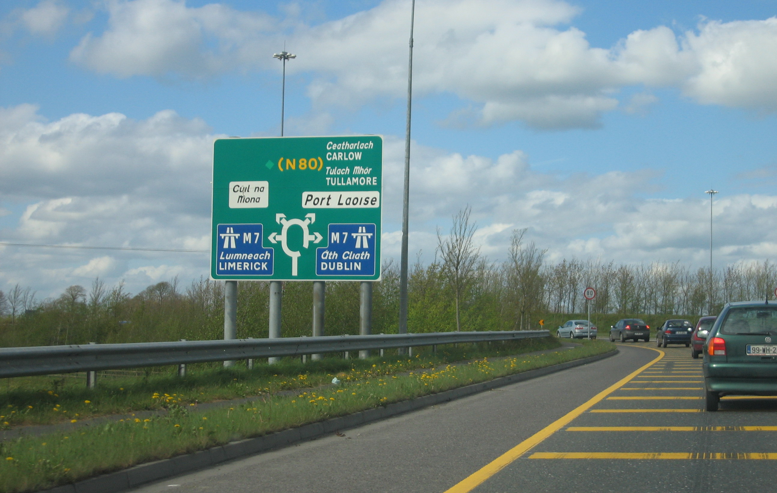
 N11 Junction 23; new standard exit sign for restricted access roads in Ireland.Main articles: Motorways in Ireland and High Quality Dual Carriageway
Under the National Development Plan, the major national motorways - the N6 from Dublin to the Border, N6 (along with that section of the N4 leading to it) Dublin to Galway, N7 Dublin to Limerick, N8 Portlaoise to Cork, and N9 Dublin to Waterford are being upgraded to motorway or high-quality dual-carriageway standard. These roads have at least two lanes in each direction, an unbroken central median, and access only at special interchanges. In addition motorways have a set of regulations limiting access to certain types of motor vehicle traffic and other special rules, including higher speed limits of 120 km/h. Upgrades to the specified roads are intended to be completed by 2010. In addition, a new motorway – the M50 – has been built around Dublin. Where a section of national primary road is designated a motorway, signage is white-on-blue instead of white-on-green, in addition, the prefix "N" is dropped, and replaced with "M" instead on road signs. A high quality dual carriageway may be redesignated a motorway by means of an order under the Roads Act 2007.
In addition to the major inter-urbans, the N11, N17, N18, N20, N21, and N25 – all of which form links between regional cities or other strategic links – will have major sections of good standard dual carriageway (in the N18's case, the entire route is planned to be dual carriageway or motorway), with some sections of motorway also possible. Current plans are to substantially replace the existing N20 with a motorway (the M20).[5]
Based on the combined lengths of existing roads, current construction and proposed future construction, it is probable that over 50% of the national primary road network will be either motorway, high-quality dual carriageway or 2+2 dual-carriageway by 2015. Approximately 38.5% (1,105km) of the network may be motorway.
List of National Primary Roads
This list of national primary roads, and their descriptions, is based on the Roads Act 1993 (Classification of National Roads) Order 2006.[6] The road lengths are from National Route Lengths as of 31/12/2007 published by the NRA[7] and are accurate to the end of 2007. Most lengths have been rounded slightly.
National Primary Roads in Ireland Road Name Description Length 


Dublin – Border (North of Dundalk) – (A1 Newry – Belfast) 94.09 km (58.46 mi) 

Dublin – Monaghan – (A5 Omagh – Derry) 139.90 km (86.93 mi) 

Dublin – Cavan – Ballyshannon 134.18 km (83.38 mi) 

Dublin – Sligo 207.31 km (128.82 mi) 
(N4 from Dublin) – Longford – Castlebar – Westport 133.70 km (83.08 mi) 

(N4 from Dublin) – Kinnegad – Galway 158.06 km (98.21 mi) 


Dublin – Limerick 187.20 km (116.32 mi) 


(N7 from Dublin) – Portlaoise – Cork 167.48 km (104.07 mi) 

(N7 from Dublin) – Newbridge – Carlow – Waterford 116.44 km (72.35 mi) 
(N9 from Dublin) – Paulstown – Kilkenny – Ballyhale – (N9 to Waterford) 38.05 km (23.64 mi) 

Dublin – Wexford 134.44 km (83.54 mi) 
Monaghan – Border (Ardgonnell Bridge) – (A3 to Belfast) 6.87 km (4.27 mi) 
(N15 from Sligo) – Stranorlar – Letterkenny – (A2 to Derry, A6, M22, M2 to Belfast) 43.90 km (27.28 mi) 
Letterkenny – Lifford – (A5 to Strabane) 18.95 km (11.77 mi) 
Sligo – Donegal – Lifford – (B72, A5 to Derry) 111.01 km (68.98 mi) 
Sligo – (A4 to Enniskillen, A4, M1 to Belfast) 47.60 km (29.58 mi) 
Galway – Claremorris – Collooney – (N4 to Sligo) 123.31 km (76.62 mi) 

(N4, N17 from Sligo) – Claregalway – (N6 from Galway) Oranmore – Ennis – Limerick 96.21 km (59.78 mi) 
(N18 from Limerick/Ennis) – Shannon Town – Shannon Airport 4.04 km (2.51 mi) 

Limerick – Cork 99.44 km (61.79 mi) 
Limerick – Castleisland – Tralee 89.92 km (55.87 mi) 
Cork – Killarney – Farranfore – (to junction with N21 to Tralee) 112.29 km (69.77 mi) 
(N21 from Limerick) – Castleisland – Farranfore – (N22 to Killarney) 9.03 km (5.61 mi) 
Limerick – Waterford 114.92 km (71.41 mi) 

Cork – Waterford – Rosslare Europort 205.54 km (127.72 mi) 
(N4, N5 from Dublin) – Swinford – Ballina 29.75 km (18.49 mi) 
Cork city centre – Cork Airport 6.40 km (3.98 mi) 
Cork – Ringaskiddy 11.80 km (7.33 mi) 
(Spur off N25 east of Waterford to Belview Port) 2.86 km (1.78 mi) 
(N25 from Cork, Waterford near New Ross) – Enniscorthy – (N11 to Dublin) 33.16 km (20.60 mi) 
M50 (junction 13) – Leopardstown Rd – Brewery Rd – (N11 at Stillorgan) – Dún Laoghaire port 7.33 km (4.55 mi) 
(Continuation of M50 to Malahide Road) 3.23 km (2.01 mi) 
(Spur off M1 to Ardee) 7.93 km (4.93 mi) 
M50/Dublin ring-road: East Wall – (M1 to Dublin and Belfast) – Turnapin – Palmerstown – Redcow – Shankill (N11 to Wexford). 47.24 km (29.35 mi) Total Length of Network: 2,743.58 km (1,704.78 mi) See also
- Roads in Ireland
- Motorways in the Republic of Ireland
- National secondary road
- Regional road
- Local Roads in Ireland
- Atlantic Corridor
- Dublin Port Tunnel
- Jack Lynch Tunnel
- History of Roads in Ireland
- Trunk Roads in Ireland
- National Roads Authority
- Road signs in the Republic of Ireland
- Road speed limits in the Republic of Ireland
- Vehicle registration plates of Ireland
- Northern Irish Vehicle Registration Plates
- Transport in Ireland
- List of Ireland-related topics
References
- ^ "Local Government (Roads and Motorways) Act, 1974". Irish Statue Book, Attorney General of Ireland. http://www.irishstatutebook.ie/1974/en/act/pub/0006/index.html.
- ^ "S.I. No. 164/1977 – Local Government (Roads and Motorways) Act, 1974 (Declaration of National Roads) Order, 1977.". Irish Statue Book, Attorney General of Ireland. http://www.irishstatutebook.ie/1977/en/si/0164.html.
- ^ "Roads Act, 1993". Irish Statue Book, Attorney General of Ireland. http://www.irishstatutebook.ie/1993/en/act/pub/0014/index.html.
- ^ [1] S.I. No. 209/1994 — Roads Act, 1993 (Declaration of National Roads) Order, 1994
- ^ "N20 brochure Route Options". http://www.corkrdo.ie/files/N20%20brochure%20Route%20Options.pdf.
- ^ "Roads Act 1993 (Classification of National Roads) Order 2006". Department of Transport. http://www.transport.ie/upload/general/7616-0.pdf.
- ^ "National Route Lengths as of 31/12/2007". National Roads Authority. http://www.nra.ie/Publications/DownloadableDocumentation/Transportation/file,15348,en.pdf.
Roads in Ireland Motorways National primary roads National secondary roads Regional roads (R101–R399) R101 · R102 · R103 · R104 · R105 · R106 · R107 · R108 · R109 · R110 · R111 · R112 · R113 · R114 · R115 · R116 · R117 · R118 · R119 · R120 · R121 · R122 · R123 · R124 · R125 · R126 · R127 · R128 · R129 · R130 · R131 · R132 · R133 · R134 · R135 · R136 · R148 · R149 · R150 · R151 · R152 · R153 · R154 · R155 · R156 · R157 · R158 · R159 · R160 · R161 · R162 · R163 · R164 · R165 · R166 · R167 · R168 · R169 · R170 · R171 · R172 · R173 · R174 · R175 · R176 · R177 · R178 · R179 · R180 · R181 · R182 · R183 · R184 · R185 · R186 · R187 · R188 · R189 · R190 · R191 · R192 · R193 · R194 · R195 · R196 · R197 · R198 · R199 · R200 · R201 · R202 · R203 · R204 · R205 · R206 · R207 · R208 · R209 · R210 · R211 · R212 · R213 · R214 · R229 · R230 · R231 · R232 · R233 · R234 · R235 · R236 · R237 · R238 · R239 · R240 · R241 · R242 · R243 · R244 · R245 · R246 · R247 · R248 · R249 · R250 · R251 · R252 · R253 · R254 · R255 · R256 · R257 · R258 · R259 · R260 · R261 · R262 · R263 · R264 · R265 · R266 · R267 · R268 · R277 · R278 · R279 · R280 · R281 · R282 · R283 · R284 · R285 · R286 · R287 · R288 · R289 · R290 · R291 · R292 · R293 · R294 · R295 · R296 · R297 · R298 · R299 · R310 · R311 · R312 · R313 · R314 · R315 · R316 · R317 · R318 · R319 · R320 · R321 · R322 · R323 · R324 · R325 · R326 · R327 · R328 · R329 · R330 · R331 · R332 · R333 · R334 · R335 · R336 · R337 · R338 · R339 · R340 · R341 · R342 · R343 · R344 · R345 · R346 · R347 · R348 · R349 · R350 · R351 · R352 · R353 · R355 · R356 · R357 · R358 · R359 · R360 · R361 · R362 · R363 · R364 · R365 · R366 · R367 · R368 · R369 · R370 · R371 · R372 · R373 · R374 · R375 · R376 · R377 · R378 · R379 · R389 · R390 · R391 · R392 · R393 · R394 · R395 · R396 · R397 · R398 · R399Regional roads (R400–R699) R400 · R401 · R402 · R403 · R404 · R405 · R406 · R407 · R408 · R409 · R410 · R411 · R412 · R413 · R414 · R415 · R416 · R417 · R418 · R419 · R420 · R421 · R422 · R423 · R424 · R425 · R426 · R427 · R428 · R429 · R430 · R431 · R432 · R433 · R434 · R435 · R436 · R437 · R438 · R439 · R440 · R441 · R442 · R443 · R444 · R445 · R446 · R448 · R449 · R458 · R459 · R460 · R461 · R462 · R463 · R464 · R465 · R466 · R467 · R468 · R469 · R470 · R471 · R472 · R473 · R474 · R475 · R476 · R477 · R478 · R479 · R480 · R481 · R482 · R483 · R484 · R485 · R486 · R487 · R488 · R489 · R490 · R491 · R492 · R493 · R494 · R495 · R496 · R497 · R498 · R499 · R500 · R501 · R502 · R503 · R504 · R505 · R506 · R507 · R509 · R510 · R511 · R512 · R513 · R514 · R515 · R516 · R517 · R518 · R519 · R520 · R521 · R522 · R523 · R524 · R525 · R526 · R527 · R548 · R549 · R550 · R551 · R552 · R553 · R554 · R555 · R556 · R557 · R558 · R559 · R560 · R561 · R563 · R564 · R565 · R566 · R567 · R568 · R569 · R570 · R571 · R572 · R573 · R574 · R575 · R576 · R577 · R578 · R579 · R580 · R581 · R582 · R583 · R584 · R585 · R586 · R587 · R588 · R589 · R590 · R591 · R592 · R593 · R594 · R595 · R596 · R597 · R598 · R599 · R600 · R601 · R602 · R603 · R604 · R605 · R606 · R607 · R608 · R609 · R610 · R611 · R612 · R613 · R614 · R615 · R616 · R617 · R618 · R619 · R620 · R621 · R622 · R623 · R624 · R626 · R627 · R628 · R629 · R630 · R631 · R632 · R633 · R634 · R635 · R637 · R638 · R639 · R659 · R660 · R661 · R662 · R663 · R664 · R665 · R666 · R667 · R668 · R669 · R670 · R671 · R672 · R673 · R674 · R675 · R676 · R677 · R678 · R679 · R680 · R681 · R682 · R683 · R684 · R685 · R686 · R687 · R688 · R689 · R690 · R691 · R692 · R693 · R694 · R695 · R696 · R697 · R698 · R699Regional roads (R700–R940) R700 · R701 · R702 · R703 · R704 · R705 · R706 · R707 · R708 · R709 · R710 · R724 · R725 · R726 · R727 · R729 · R730 · R731 · R733 · R734 · R735 · R736 · R737 · R738 · R739 · R740 · R741 · R742 · R743 · R744 · R745 · R746 · R747 · R748 · R749 · R750 · R751 · R752 · R753 · R754 · R755 · R756 · R757 · R758 · R759 · R760 · R761 · R762 · R763 · R764 · R765 · R766 · R767 · R768 · R769 · R770 · R772 · R773 · R774 · R801 · R802 · R803 · R804 · R805 · R806 · R807 · R808 · R809 · R810 · R811 · R812 · R813 · R814 · R815 · R816 · R817 · R818 · R819 · R820 · R821 · R822 · R824 · R825 · R826 · R827 · R828 · R829 · R830 · R831 · R833 · R834 · R835 · R836 · R837 · R838 · R839 · R840 · R841 · R842 · R843 · R846 · R847 · R848 · R849 · R851 · R852 · R853 · R854 · R855 · R857 · R858 · R859 · R860 · R863 · R864 · R865 · R866 · R867 · R868 · R870 · R871 · R873 · R874 · R875 · R876 · R877 · R880 · R883 · R884 · R885 · R886 · R887 · R888 · R889 · R890 · R891 · R895 · R896 · R898 · R899 · R900 · R901 · R902 · R903 · R904 · R906 · R907 · R908 · R909 · R910 · R911 · R913 · R914 · R915 · R916 · R917 · R918 · R919 · R920 · R921 · R922 · R923 · R924 · R925 · R926 · R927 · R928 · R929 · R930 · R931 · R932 · R933 · R934 · R935 · R936 · R937 · R940Categories:- National primary roads in the Republic of Ireland
- Types of roads


Wikimedia Foundation. 2010.