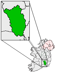
County Kilkenny — For other uses, see Kilkenny (disambiguation). County Kilkenny Contae Chill Chainnigh Coat of a … Wikipedia
N10 road (Ireland) — N10 road Location Primary destinations: County Kilkenny Paulstown – (N9 from Dublin) (N77 to Dur … Wikipedia
Полстаун — Деревня Ирландии Полстаун англ. Paulstown, ирл. Baile Phóil Страна И … Википедия
N9 road (Ireland) — N9 road Route information Length: 111 km (69 mi) Location … Wikipedia
Darren O’Neill — (* 13. September 1985) ist ein irischer Boxer. Er wurde 2010 Vize Europameister im Mittelgewicht. Inhaltsverzeichnis 1 Werdegang 2 Internationale Erfolge 3 Irische Meisterschaften … Deutsch Wikipedia
Kilkenny — For other uses, see Kilkenny (disambiguation). Kilkenny Cill Chainnigh City … Wikipedia
List of towns and villages in the Republic of Ireland — This is a link page for cities and towns in Ireland, including villages, townships or urban centres in Dublin. Cities are shown in bold; see Cities in Ireland for an independent list. See also : * List of towns in the Republic of Ireland/Largest… … Wikipedia
Roads in Ireland — Ireland, both north and south of the border, has an extensive network of roads. Northern Ireland has had motorways since 1962, and has well developed primary routes. With the advent of the Celtic Tiger and European Union funding, most national… … Wikipedia
Roscrea — Infobox Irish Place name = Roscrea gaeilge = Ros Cré crest motto = map pin coords = left: 58px; top: 32px north coord = 52.954688 west coord = 7.797117 irish grid = S132894 area = tipperary elevation = 126 m (413 ft) province = Munster county =… … Wikipedia
List of census towns in the Republic of Ireland — This page lists the towns of Ireland as defined by the Central Statistics Office for the 2002 census.Under the Local Government Acts, 1994 (S.I. 171 of 1994) and 2001 (S.I. 591 of 2001), the following cities and towns have legally defined… … Wikipedia