- Clongriffin
-
Clongriffin
Cluain Ghrífín— Suburb —  Outdoor Chess, Fr. Collins Park, Donaghmede
 Location in Ireland
 Clongriffin
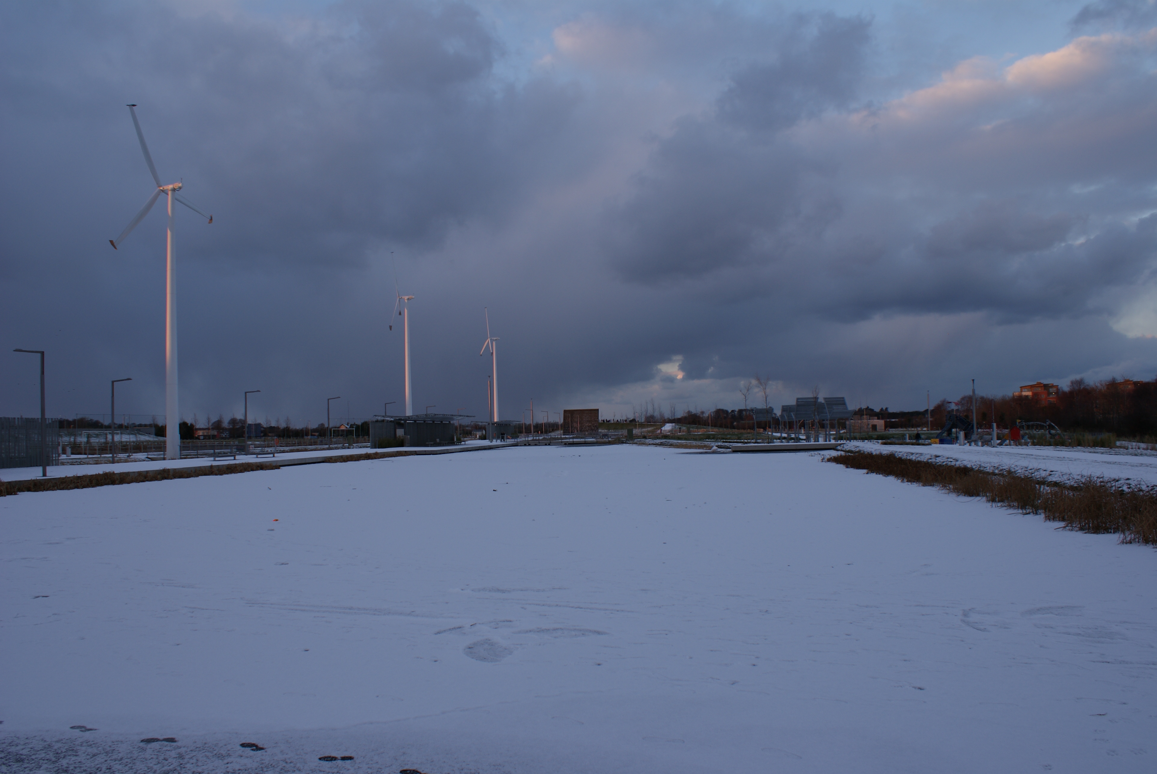
Coordinates: 53°23′41″N 6°9′43″W / 53.39472°N 6.16194°WCoordinates: 53°23′41″N 6°9′43″W / 53.39472°N 6.16194°W Country Ireland Province Leinster County County Dublin Time zone WET (UTC+0) - Summer (DST) IST (WEST) (UTC-1) Irish Grid Reference 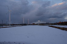 Lake frozen over in Fr. Collins Park with distinctive wind turbines in the background.
 Clongriffin Park and Ride facility.
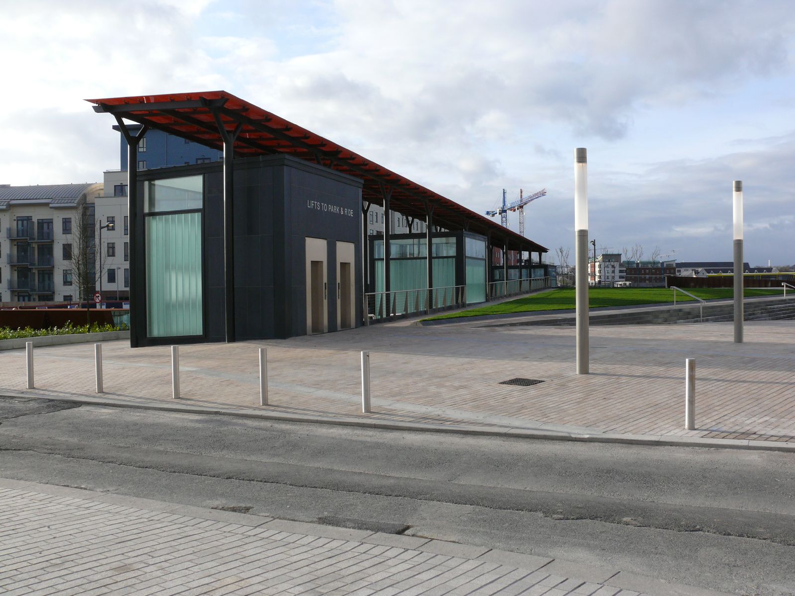
Clongriffin (Irish: Cluain Ghrífín, meaning "Meadow of the Griffin") is a new locality in northern Donaghmede,[1] Dublin, Ireland.
Contents
Name
The name Clongriffin is a modern invention, a concatenation of 'clon', the anglicisation of cluain (the Irish word for meadow) and griffin. A griffin, griffon or gryphon (the Irish of which is ghrífín) is a mythical beast and is an element in the name of the adjacent district, Balgriffin.
Architect David Wright, a former employee of Conroy Crowe Kelly Architects & Urban Designers,[2] allegedly gave Clongriffin its name while working on its development.[3]
Location
Approximately 2 km (1.24 mi) inland from Baldoyle Estuary and approximately 10 km (6.21 mi) north east of Dublin city centre, Clongriffin is in northern Donaghmede, at the northern edge of Dublin's municipal suburbs, in the jurisdiction of Dublin City Council. The development lies within the townland of Grange, in the civil parish of Baldoyle, from which Donaghmede was largely formed.
Clongriffin is in the Dublin Postal District Dublin 13, and in the constituency of Dublin North East.
Transport & Access
Road
By road, access is via Hole in the Wall Road, a short distance from Grange Road and the N32 from Malahide Road, M50 and M1.
Rail
Clongriffin railway station is situated along the Dublin–Belfast railway line between Howth Junction and Portmarnock railway station, and is served by Dublin Area Rapid Transit (DART) and InterCity (Iarnród Éireann).
A "Park-and-Ride" underground car park, with more than 500 spaces, is located on Clongriffin's Main Street.
Bus
Dublin Bus provides the 128 service which is one of Dublin's 'cross town' routes.[4] It serves from Station Square, Clongriffin to Palmerston Park, Rathmines via Malahide Road, Dublin Connolly railway station, Nassau Street, Dublin, and St Stephen's Green.
Also, the 29n Nitelink service [5] provides late night service from D'Olier Street to Baldoyle Road, stopping on Grange Road approximately 1 km from Main Street, Clongriffin.
Amenities & Facilities
Clongriffin is currently serviced by a small supermarket (which also contains a sub-post office), an off-license, barber and a Chinese restaurant, most at the beginning of the designated main street. Existing shopping facilities nearby (between 1 and 3 km away) include small shopping plaza at Baldoyle, and the larger Donaghmede Shopping Centre and Clarehall Shopping Centre.
Occasionally, there is a market held at Station Square.
Cycling, walking and running
Station Square is a meeting point of several pedestrian, running and cycle routes. From the square, there is passage to Father Collins Park and beyond the civic steps to Dublin coastal walkways and Baldoyle Bay (the estuary of two rivers, and a noted wetland), declared a Nature Reserve in 1988.
Father Collins Park
Now Ireland's first wind powered and 'self-sustainable' public park, the redeveloped Father Collins Park adjacent to Clongriffin was officially reopened in May 2009.[6]
The park has since won a number of awards such as The Sustainability Award 2010, Best Public Space 2010, and Best Public Park & Best Environmentally Friendly Initiative for 2010.[7] Most recently, it was short listed by the European Union Prize for Contemporary Architecture 2011.
With five 50 kW wind turbines, it provides power for the projection of water from its central lake, the public lighting, maintenance depots, and sport club changing rooms.
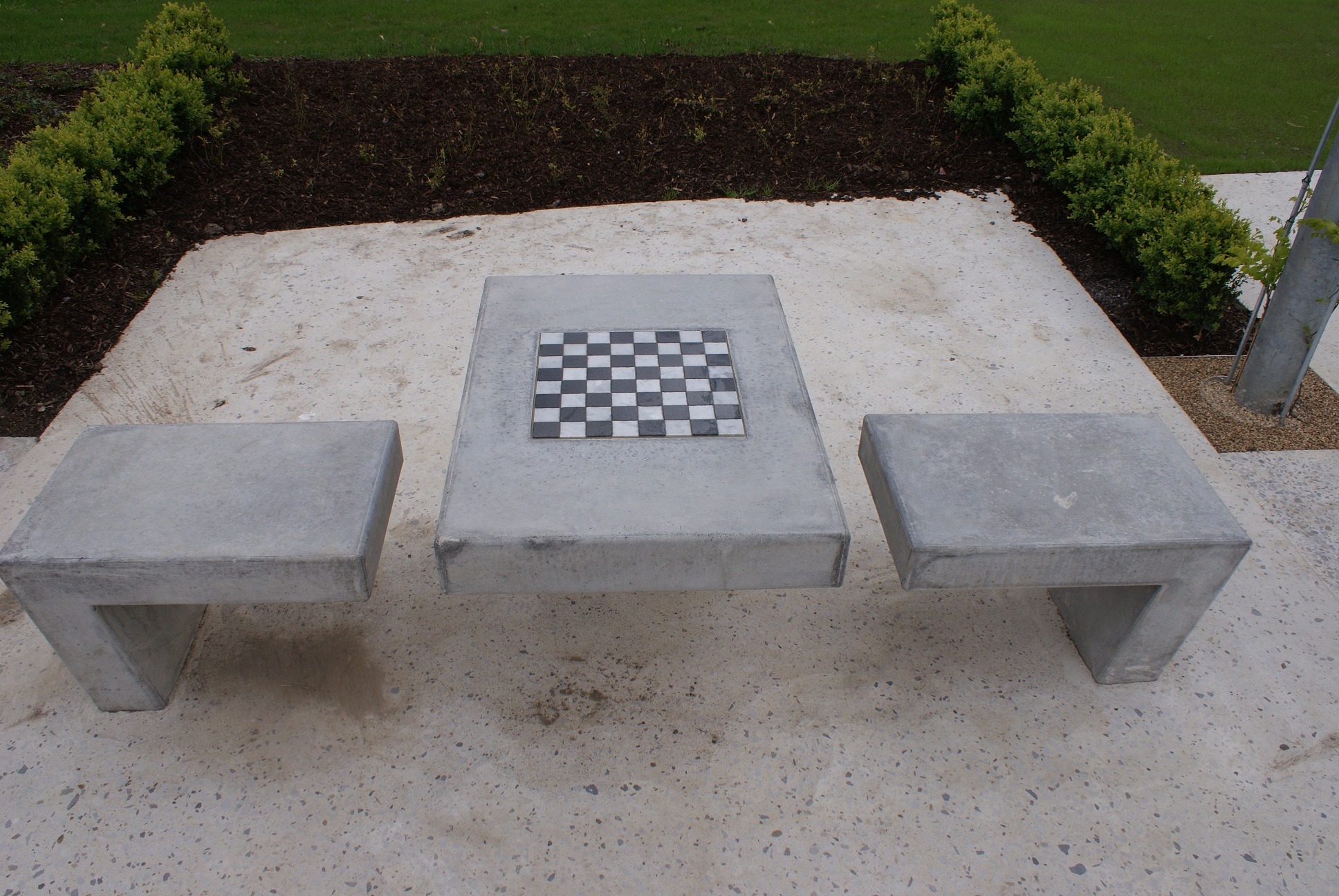
The approximately 54 acre (or 26 hectares) park encompasses some natural woodland; for sports, a peripheral running/cycling track, six playing pitches and six fitness stations; for leisure, a prominade, a concert amphitheatre and picnic areas with outdoor chess/draughts boards; and for activity, two playgrounds and a skate-park.
Education
Clongriffin has a crèche, The Learning Circle. Two new primary schools lie to the west of Clongriffin in Belmayne, another constituent estate of the North Fringe. One, St. Francis of Assisi, is under the patronage of the Roman Catholic Church and the other is an Educate Together facility. There are other nearby primary schools and second level schools in Donaghmede and Baldoyle.
Religion
The Holy Trinity Church [8] serves the Roman Catholic parishioners of Donaghmede-Clongriffin-Balgriffin Parish, the inception of which was in 1974.
St. Doulagh's Church, Balgriffin serves Church of Ireland parishioners.[9] The church has been used for services since the Tudor conquest of Ireland.
Nature
Clongriffin is also adjacent to Baldoyle Bay, with the estuaries of the Sluice River and Mayne River, and wetlands, all of which are protected by the National Parks and Wildlife Service.[10]
Declared a Statutory Nature Reserve in 1988,[11] the inner estuarine part of the estuary and wetlands of Baldoyle Bay are protected as a Special Area of Conservation (SAC).[12] Under the Ramsar Convention, the wetlands have been designated as of international importance. They support several habitats that are listed on the EU Habitats Directive.[13]
The open lands of Clongriffin and Father Collins Park continue to host migrating birds, including Arctic and African-Eurasian migratory birds. Of particular interest is the internationally important population of Brent Geese who frequent the broad area around Baldoyle Bay.[14][15]
There was until the late 1990's a stream running west and north west from the south eastern corner of Father Collins Park (where Main Street now passes), to Stapolin and into the Grange Stream tributary of the Mayne River. This stream is no longer visible.
History and composition
Early history
The lands of Baldoyle, on which Clongriffin is situated, formed part of a large tract of high medieval monastic grange farmland, sometimes called the "Grange of Baldoyle." A reminder of this is the small church now called Grange Abbey to the south of Clongriffin. In 1166, the lands were assigned to All Saints Priory, on whose site Trinity College Dublin was later built, by Diarmait Mac Murchada, King of Leinster.[16]
In 1369, parliament was held in the small church, called by Sir William de Windsor.[17]
In the late 1530s, at the beginning of the Tudor conquest of Ireland, the entire settlement was invaded and seized at the behest of King Henry VIII of England, who in 1538 bestowed it on the Corporation of Dublin.
Modern history
Until 2003, most of the lands on which Clongriffin is being built remained as farmland.
In July of the same year Dublin City Council granted planning permission for a mixed-use development to be called, 'Clongriffin at Grange Road, Donaghmede' [1] now forming part of the 'Northern Fringe Development' (from Clongriffin to Belmayne).[18]
With management plans completed in 2004, the development, comprising houses and apartments, started in 2005, and was planned to have educational, retail and service facilities, including a multi-screen cinema. Forming part of the Northern Fringe Development (along with Belmayne in Balgriffin and estates on the former Baldoyle Racecourse and in north Coolock), approved by the local authorities to provide new accommodation for Dublin on what was "green belt" land, and was to complete the development of north Donaghmede. Clongriffin's developments comprise of Grange Lodge, Beau Park, Station Point and Marrsfield.[19]
For further history and general notes, see also the Donaghmede and Baldoyle articles.
Provision of services
No area of the estate has yet been taken in charge by Dublin City Council and the Council maintains that it has made no commitment in this respect.[1] Nevertheless, refuse collection responsibility is taken by the Dublin City Council in tandem with the private management company. However, it has been relayed to the local community that Irish Rail requested that Dublin City Council take Main Street in charge before the opening of the railway station.[20]
Pyrite settlement and remediation
In early 2008 it was alleged that the mineral pyrite was found in the stone hardcore used in the construction of some residential units in various estates in north Dublin, including Beaupark in Clongriffin.[21] Currently, pyrite remedition of affected ground level dwellings is underway,[22] after, in March 2011, a settlement was reached in the pyrite Commercial Court case. Menolly Homes [23] and The Lagan Group [24] accepted responsiblity for the defective infill used, and have set up of a Trust Fund to cover costs for remediation of all homes affected by pyrite in Clongriffin.[25] In May 2011, remediation began.
Road maintenance and other developments
Roads in the main Clongriffin development are thought to be maintained by Gannon Homes,[26] however, responsibility for the upkeep of the roads remains under dispute.
Development has been stalled as a result of the downturn in the Irish economy, developer financial problems, and reduced demand. Some areas remain enclosed by construction hoarding. Dublin City Council are formulating a Local Area Plan for the North Fringe [27] as part of the Dublin City Development Plan 2011-2017.[28] This plan will guide future development in the area.
References & Notes
- ^ a b c Dublin: Dublin City Council, Minutes of full Meeting of Council, April 2009, Q. 36 - City Manager's answer.
- ^ Conroy Crowe Kelly
- ^ Sunday Independent LIFE Magazine, 1 March, 2009, "Blame it all on the Lego"
- ^ Dublin Bus 128 Service & Timetable
- ^ Dublin Bus 29n Service & Timetable
- ^ Dublin City Parks - Fr Collins Park
- ^ KSN Energy
- ^ Holy Trinity Church, Donaghmede-Clongriffin-Balgriffin Parish
- ^ The United Parishes of Malahide, Portmarnock & St Doulagh's - Church of Ireland
- ^ National Parks and Wildlife Service (Ireland), Baldoyle Bay SPA 004016
- ^ Irish Statute Book, S.I. No. 233/1988 — Nature Reserve (Baldoyle Estuary) Establishment Order, 1988
- ^ Natural Heritage Designations, Baldoyle Bay
- ^ Habitats Directive, Environmental Legislation
- ^ National Parks and Wildlife Services, Baldoyle Bay Specially Protected Sites
- ^ National Parks & Wildlife Services
- ^ Grange Abbey, Baldoyle by Brian Mac Giolla Phadraigh. Dublin Historical Record @ 1965
- ^ An article on Fingal district, by William C. Stubbs, M.A., in the Journal of the Royal Society of Antiquaries for 1897; Dalton's History of the County Dublin; Archdall's Monasticon Hibernicum (Moran's).
- ^ Dublin City Council - Clongriffin – Belmayne (North Fringe)
- ^ Clongriffin Town Centre
- ^ North Area Assistant Manager at the Safer Belmayne/Clongriffin Forum, Shop Unit 60, Main St. Clongriffin, 19th May, 2009.
- ^ Report on presence of pyrite in Beaupark, Clongriffin to DCC North Central Area Committee
- ^ The Planning and Development (Amendment) Act 2010
- ^ Menolly Homes
- ^ The Lagan Group
- ^ Irish Times - Pyrite housing settlement outlined
- ^ Gannon Homes
- ^ North Fringe Local Area Plan
- ^ Dublin City Development Plan 2011-2017
Categories:

Wikimedia Foundation. 2010.