- Nomenclature of Territorial Units for Statistics
-
"NUTS" redirects here. For the nuclear warfare strategy, see Nuclear utilization target selection. For other uses, see Nut.
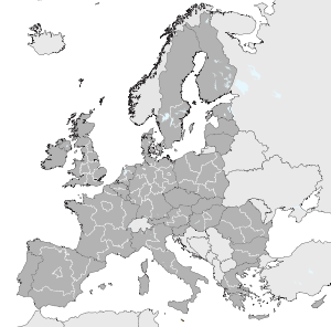
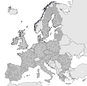
The Nomenclature of Territorial Units for Statistics[1][2] or Nomenclature of Units for Territorial Statistics[3][4][5][6] (NUTS,[1][2][3][4][5][6][7][8][9][10] after the French nomenclature d'unités territoriales statistiques[citation needed]) is a geocode standard for referencing the subdivisions of countries for statistical purposes. The standard is developed and regulated by the European Union, and thus only covers the member states of the EU in detail. The Nomenclature of Territorial Units for Statistics is instrumental in European Union's Structural Fund delivery mechanisms.
For each EU member country, a hierarchy of three NUTS levels is established by Eurostat; the subdivisions in some levels do not necessarily correspond to administrative divisions within the country. A NUTS code begins with a two-letter code referencing the country, which is identical to the ISO 3166-1 alpha-2 code (except UK instead of GB for the United Kingdom). The subdivision of the country is then referred to with one number. A second or third subdivision level is referred to with another number each. Each numbering starts with 1, as 0 is used for the upper level. In case the subdivision has more than nine entities, capital letters are used to continue the numbering. A similar statistical system is defined for the candidate countries and members of the European Free Trade Association, but they are not technically part of NUTS governed by the regulations.
The current NUTS classification valid from 1 January 2008 until 31 December 2011 lists 97 regions at NUTS 1, 271 regions at NUTS 2 and 1303 regions at NUTS 3 level.[11]
In addition to the full three levels for the European Union countries, all other countries have a NUTS code with a two-letter code for a continent and two numbers for the country, and for the USA, Canada and Australia the states, provinces, and territories are numbered separately. There are some anomalies: for example, Gibraltar is listed as being outside the EU with the code EO21; while French Guiana is listed twice, once in France as FR930 and once in South America as AS13. NUTS is thus in some extent similar to the ISO 3166-2 standard, as well as the FIPS 10-4 standard of the United States.
Contents
Levels
See also: First level NUTS of the European UnionThere are three levels of NUTS defined, with two levels of local administrative units (LAUs) below. These were called NUTS levels 4 and 5 until July 2003, but were officially abolished by regulation, although they are sometimes still described as such. Note that not all countries have every level of division, depending on their size. One of the most extreme cases is Luxembourg, which has only LAUs; the three NUTS divisions each correspond to the entire country itself.
Countries NUTS 1 NUTS 2 NUTS 3 EU members 27 97 271 1303 Austria AT Groups of states 3 States 9 Groups of districts 35 Belgium BE Regions 3 Provinces (+ Brussels) 11 Arrondissements (Verviers split into two) 44 Bulgaria BG Regions 2 Planning regions 6 Oblasts 28 Cyprus CY — 1 — 1 — 1 Czech Republic CZ — 1 Oblasts 8 Regions 14 Germany DE States 16 Government regions (or equivalent) 39 Districts 429 Denmark DK — 1 Regions 5 Lands 11 Estonia EE — 1 — 1 Groups of counties 5 Spain ES Groups of autonomous communities 7 17 Autonomous communities and 2 autonomous cities 19 Provinces + Islands + Ceuta and Melilla 59 Finland FI Mainland Finland, Åland 2 Large areas 5 Regions 20 France FR Z.E.A.T. + DOM 9 Regions + DOM 26 Departments + DOM 100 Greece GR Groups of development regions 4 Peripheries 13 Prefectures 51 Hungary HU Statistical large regions 3 Planning and statistical regions 7 Counties + Budapest 20 Ireland IE — 1 Regional Assemblies 2 Regional Authorities 8 Italy IT Groups of regions 5 Regions (Trentino-Alto Adige/Südtirol split into two) 21 Provinces 107 Lithuania LT — 1 — 1 Counties 10 Luxembourg LU — 1 — 1 — 1 Latvia LV — 1 — 1 Regions (+ Riga) 6 Malta MT — 1 — 1 Islands 2 Netherlands NL Groups of provinces 4 Provinces 12 COROP regions 40 Poland PL Regions 6 Voivodeships 16 Subregions 66 Portugal PT Continent (+ Azores and Madeira) 3 Regional Coordination Commissions + Autonomous regions 7 Groups of municipalities 30 Romania RO Macroregions 4 Regions 8 Counties + Bucharest 42 Sweden SE Regions 3 National areas 8 Counties 21 Slovenia SI — 1 Macroregions 2 Statistical regions 12 Slovakia SK — 1 Oblasts 4 Regions 8 United Kingdom UK Regions of England 9 Counties (some grouped); Inner and Outer London 30 Upper tier authorities or groups of lower tier authorities (unitary authorities or districts) 93 Wales 1 Groups of unitary authorities 2 Groups of unitary authorities 12 Scotland 1 Groups of unitary authorities or districts 4 Groups of unitary authorities or districts 23 Northern Ireland 1 — 1 Groups of districts 5 Candidate countries 5 16 32 113 Croatia HR — 1 Regions 3 Counties 21 Iceland IS — 1 — 1 Capital area / Rest of country 2 Macedonia MK — 1 — 1 Statistical regions 8 Montenegro ME — 1 — 1 — 1 Turkey TR Regions 12 Sub-regions 26 Provinces 81 EFTA countries 3 3 15 46 Liechtenstein LI — 1 — 1 — 1 Norway NO — 1 Regions 7 Counties 19 Switzerland CH — 1 Regions 7 Cantons 26 Establishment
The NUTS-region are based on the existing national administrative subdivisions. In countries where only one or two regional subdivisions exist, or where the size of existing subdivisions is too small, a second and/or third level is created. This may be on the first level (ex. France, Italy, Greece, and Spain), on the second (ex. Germany) and/or third level (ex. Belgium).[12] In smaller countries, where the entire country would be placed on the NUTS 2 or even NUTS 3 level (ex. Luxembourg, Cyprus, Ireland), levels 1, 2 and/or 3 are identical to the level above and/or to the entire country.
The thresholds in the table below are used as guidelines for establishing the regions, but they are not applied rigidly. For example, both Cornwall, population 531,600 in 2007, and Lombardy, with a population of nearly ten million, are NUTS 2 regions.
Level Minimum Maximum NUTS 1 3 million 7 million NUTS 2 800 000 3 million NUTS 3 150 000 800 000 Examples
- DE: Germany
- DE7: Hessen - The Bundesland as the top level subdivision of Germany
- DE71: Darmstadt region - Regierungsbezirk as second level
- DE71E: Wetteraukreis - Kreis as the third level
- DE71: Darmstadt region - Regierungsbezirk as second level
- DE7: Hessen - The Bundesland as the top level subdivision of Germany
- AA: Asia
- AA25: Thailand
- US16: Kansas
See also
- ISO 3166
- ISO 3166-1
- ISO 3166-2
- List of FIPS region codes
- Local administrative unit
- Regions of the European Union
- List of metropolitan areas in Europe by population
References
- ^ a b Ramon
- ^ a b European Commission wiki
- ^ a b MAGIC (a GIS project of DEFRA, English Heritage, Natural England, Environment Agency, Forestry Commission, Department for Communities and Local Government)
- ^ a b Office for National Statistics
- ^ a b Hansard, written proceedings of the UK Parliament
- ^ a b Department for Environment, Food and Rural Affairs
- ^ Regulation (EC) No 176/2008 of the European Parliament and of the Council of 20 February 2008
- ^ Regulation (EC) No 1888/2005 of the European Parliament and of the Council of 26 October 2005
- ^ Commission Regulation (EC) No 105/2007 of 1 February 2007
- ^ Regulation (EC) No 1059/2003 of the European Parliament and of the Council of 26 May 2003
- ^ Official Eurostat website: Introduction.]
- ^ Europa - Eurostat - Regions - Basic principles of the NUTS
External links
- Nomenclature of territorial units for statistics - NUTS Statistical Regions of Europe
- Hierarchical list of the Nomenclature of territorial units for statistics - NUTS and the Statistical regions of Europe
- Overview maps of the NUTS and Statistical Regions of Europe
- List of NUTS regions in EU-27
- Overview map of EU Countries - Country level
- Overview map of EU Countries - NUTS level 1
- List of regions in EFTA
- Overview map of EFTA countries - Country level
- Overview map of EFTA countries - Statistical regions at level 1
- List of regions in CC
- Overview map of CC (Candidate countries) - Country level
- Overview map of CC (Candidate countries) - Statistical regions at level 1
- Correspondence between the NUTS levels and the national administrative units
- Correspondence between the regional levels and the national administrative units (EFTA and CEC countries)
- NUTS, Publications Office, European Union, EU
- Administrative Divisions of Countries ("Statoids")
AT Austria • BE Belgium • BG Bulgaria • CY Cyprus • CZ Czech Republic • DE Germany • DK Denmark • EE Estonia • ES Spain • FI Finland • FR France • GR Greece • HU Hungary • IE Ireland • IT Italy • LT Lithuania • LU Luxembourg • LV Latvia • MT Malta • NL Netherlands • PL Poland • PT Portugal • RO Romania • SE Sweden • SI Slovenia • SK Slovakia • UK United KingdomCandidate countries EFTA countries Categories:- NUTS
- Geocodes
- Statistical data coding
- DE: Germany
Wikimedia Foundation. 2010.


