- NUTS 2 statistical regions of the Republic of Ireland
-
Within the European Union, regions are arranged for statistical and revenue disbursing purposes using the NUTS structure. In Ireland, the regionalisation arrangements negotiated by the Government of Ireland in the context of Agenda 2000 resulted in the designation of the State into two regions for Eurostat and EU Structural Funds purposes. Following this designation, two new regions (and their associated Regional Assemblies) were established and came into effect in July 1999: Southern and Eastern NUTS-II Region and Border, Midland and Western NUTS-II Region.
Contents
NUTS Level 2 regions
The two NUTS 2 regions of Ireland are managed within the "Regional Assemblies in Ireland" system. Both regions had "Objective 1" status for EU Structural Funds purposes.
Border, Midland and Western — Region — 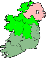
Country  Ireland
Area[1] - Total 33,252.3 km2 (12,838.8 sq mi) Population (2007)[2] - Total 1,166,500 - Density 35.1/km2 (90.9/sq mi) NUTS code IE01 GDP per capita (PPS) € 24,500 (2006)[3] - Border, Midland and Western This region's "Objective 1" status for EU Structural Funds purposes ended in 2006.
- Southern and Eastern This region's "Objective 1" status for EU Structural Funds purposes ended in 2005.
Southern and Eastern — Region — 
Country IrelandArea[10] - Total 36,544.8 km2 (14,110 sq mi) Population (2007)[11] - Total 3,190,400 - Density 87.3/km2 (226.1/sq mi) NUTS code IE02 GDP per capita (PPS) € 38,600 (2006)[12] - The remaining part of the island of Ireland, Northern Ireland, is both a NUTS 1 and a NUTS 2 level area. This means that there are two NUTS 1 entities on the island.
Regional Assemblies
Function of the assemblies
-
- to manage the Regional Operational Programmes under the National Development Plan
- to monitor the general impact of all EU programmes under the National Development Plan/Community Support Framework
- to promote coordination in the provision of public services in the Assembly areas
The Assemblies also host the INTERREG IIIB contact points in Ireland.
Membership of the assemblies
There are no direct elections to the Regional Assemblies. They are instead composed of elected representatives nominated by members of those NUTS III level Regional Authorities that comprise each NUTS II level region. Each Regional authority has a certain number of nominations to an Assembly, based loosely on the population of the Region. The BMW Assembly has a total of 29 members and the S+E Assembly has 41 members.
Governance of the assemblies
Each Assembly has an Operational Committee, which is composed of Chief Executive Officers of public authorities in the region and the Directors and Cathaoirligh (Chairpersons) of the Regional Authorities in the region. This committee is chaired by the Cathaoirleach of the Regional Assembly and its key tasks are to advise and assist the Assembly in the discharge of its functions.
Each Assembly has a Monitoring Committee for the implementation of the Regional Operational Programme in the region whose function is to:-
- satisfy itself as to the effectiveness and quality of the implementation of all expenditure;
- to consider the progress and impact of both co-financed and non-co-financed expenditure in the region; and
- to make recommendations to the Regional Assembly, the relevant implementing government department at national level and the Department of Finance.
Each Assembly has a Director and a number of policy, programme and administrative staff.
Financing the assemblies
The Assemblies are funded by central government through the Department of Finance. The costs of the other activities of the Regional Assemblies are funded by their constituent local authorities.
See also
- Local government in the Republic of Ireland
- Structural Funds and Cohesion Funds
- Region (Europe)
- NUTS 3 statistical regions of the Republic of Ireland
- ISO 3166-2:IE
- United Nations geoscheme for Europe
References
- ^ Total area and land area, by NUTS 2 regions - km2
- ^ Total average population, by NUTS 2 regions - (1 000 inhabitants)
- ^ Regional gross domestic product (PPS per inhabitant), by NUTS 2 regions
- ^ Total area and land area, by NUTS 2 regions - km2
- ^ Total average population, by NUTS 2 regions - (1 000 inhabitants)
- ^ Regional gross domestic product (PPS per inhabitant), by NUTS 2 regions
- ^ Total area and land area, by NUTS 2 regions - km2
- ^ Total average population, by NUTS 2 regions - (1 000 inhabitants)
- ^ Regional gross domestic product (PPS per inhabitant), by NUTS 2 regions
- ^ Total area and land area, by NUTS 2 regions - km2
- ^ Total average population, by NUTS 2 regions - (1 000 inhabitants)
- ^ Regional gross domestic product (PPS per inhabitant), by NUTS 2 regions
External links
Categories:- Local government in the Republic of Ireland
- NUTS 2 statistical regions of the European Union
- Regions of the Republic of Ireland


Wikimedia Foundation. 2010.