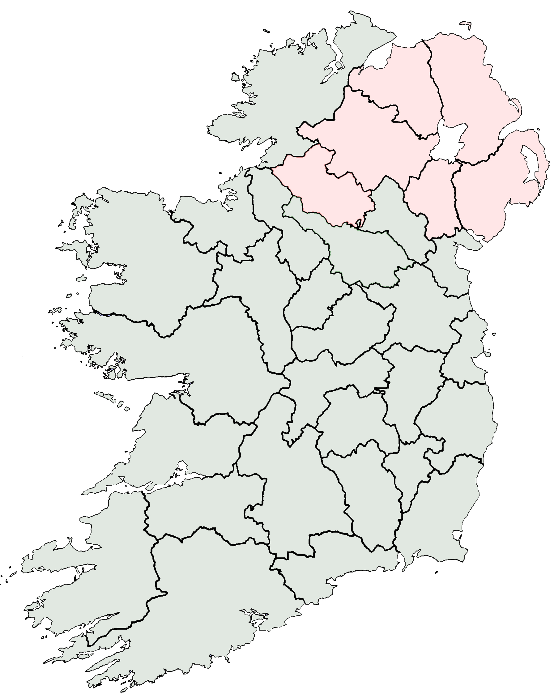
- County Louth
-
County Louth
Contae Lú
Coat of armsMotto: Lugh sáimh-ioldánach (Irish)
"Lugh equally skilled in many arts"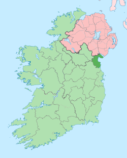
Country Ireland Province Leinster Dáil Éireann Louth EU Parliament East County seat Dundalk Government - Type County Council Area - Total 826 km2 (318.9 sq mi) Area rank 32nd Population (2011) 122,808 - Rank 18th [1] Car plates LH Website louthcoco.ie County Louth (
 /ˈlaʊð/; Irish: Contae Lú)[2][3] is a county[4] of Ireland. Louth County Council is the local authority responsible for the county, which is part of the Border Region. It is located in the province of Leinster and is named after the town of Louth. The population of the county is 122,808 according to the 2011 census.[5]
Contents
Geography and political subdivisions
County Louth is colloquially known as 'the Wee County' as it is the smallest county by area (826 km² (319sq miles).[6] It is the 19th largest in terms of population.[7] It is the smallest of Leinster’s 12 counties by size and the sixth largest by population.
Towns and villages
- Annagassan
- Ardee
- Ballymascanlan
- Baltray
- Blackrock
- Carlingford
- Castlebellingham
- Clogherhead
- Collon
- Drogheda
- Dromiskin
- Dundalk
- Dunleer
- Greenore
- Gyles' Quay
- Jenkinstown
- Knockbridge
- Louth
- Omeath
- Sandpit, County Louth
- Stonetown
- Tallanstown
- Termonfeckin
- Tullyallen
History
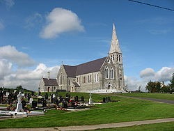 Immaculate Conception church, Co. Louth.
The official spelling in the Irish (Gaelic) language (Lú) must not be confused with the similar sounding superlative form lú meaning smaller or smallest of the adjective beag. Instead, it is derived from Lughbhaidh - the Celtic pagan god Lugh, whose festival was celebrated at Lughnasadh (Lúnasa). This is a county steeped in myth, legend and history, going back to the pre-historical days of the Táin Bó Cúailnge (Cooley Cattle Raid, see Cú Chulainn). Later it saw the influence of the Vikings as seen in the name of Carlingford Lough. There are a number of historic sites in the county, including religious sites at Monasterboice and Mellifont Abbey. In the early fourteenth century the Scottish army of Edward Bruce (brother of Robert of Bannockburn fame) was defeated in the Battle of Faughart near Dundalk, Edward losing not only his claim to the High Kingship Of Ireland, but also his life. The sixteenth and seventeenth centuries featured many skirmishes and battles involving Irish and English forces. Oliver Cromwell attacked Drogheda in 1649 slaughtering the Royalist garrison and hundreds of the town's citizens (Siege of Drogheda). Towards the end of the same century the armies of the warring Kings, James and William, faced off in South Louth during the build-up to the Battle of the Boyne - the battle takes its name from the river Boyne which reaches the sea at Drogheda.
In 1798 the leaders of the United Irishmen included Bartholomew Teeling, John Byrne and Patrick Byrne, all from Castletown; Anthony McCann from Corderry; Nicholas and Thomas Markey from Barmeath , Arthur McKeown, John Warren and James McAllister from Cambricville. They were betrayed by informers, notably a Dr. Conlan, who came from Dundalk, and an agent provocateur called Sam Turner, from Newry. Several leaders were hanged.
In 1816 the Wildgoose Lodge Murders took place in the west of the county.
The priest and scientist Nicholas Callan (1799–1864) was from Darver.
Demographics
Historical populations Year Pop. ±% 1653 8,527 — 1659 9,690 +13.6% 1821 119,129 +1129.4% 1831 124,846 +4.8% 1841 128,240 +2.7% 1851 107,662 −16.0% 1861 90,713 −15.7% 1871 84,021 −7.4% 1881 77,684 −7.5% 1891 71,038 −8.6% 1901 65,820 −7.3% 1911 63,665 −3.3% 1926 62,739 −1.5% 1936 64,339 +2.6% 1946 66,194 +2.9% 1951 68,771 +3.9% 1956 69,194 +0.6% 1961 67,378 −2.6% 1966 69,519 +3.2% 1971 74,951 +7.8% 1979 86,135 +14.9% 1981 88,514 +2.8% 1986 91,810 +3.7% 1991 90,724 −1.2% 1996 92,166 +1.6% 2002 101,821 +10.5% 2006 111,267 +9.3% 2011 122,808 +10.4% [8][9][10][11][12][13] The majority of the county's population live in either Dundalk (2006 pop. 29,037) in north Louth, or Drogheda (2006 pop. 28,973) in the south. The 2006 Census[1] confirmed Dundalk and Drogheda as not only the largest towns in the county, but also the second and third largest towns in The Republic of Ireland.
Within legally defined boundaries Dundalk has the larger population, however the total population(including suburbs or environs) is greater in Drogheda, this includes areas and suburbs of Drogheda which lie in County Meath.[1]
Local government and politics
Main article: Louth County CouncilThe local authority is Louth County Council which provides a number of services including planning, roads maintenance, fire brigade, council housing, water supply, waste collection, recycling and landfill, higher education grants and funding for arts and culture.[14]
For elections to Dáil Éireann, Louth is represented by the five member Louth constituency which takes in the entire county of Louth and small parts of eastern Meath. In the last general election 2 TD's from Fine Gael and one each from Sinn Féin, the Labour Party and Fianna Fáil were elected.
Irish language
The area of Omeath was Irish-speaking until the early 20th century. A native dialect of Louth Irish existed there until about 1930, but is now extinct, although recordings have been made.[15]
People
- Dermot Ahern - former Fianna Fáil TD for Louth
- Thomas Byrne - former racing driver
- Micheal Campbell - member of the Real IRA
- Eamonn Campbell - member of the Dubliners
- James Carroll - Fianna Fáil politician, member of Seanad Éireann from Louth
- Pierce Brosnan - actor
- The Corrs - pop/rock band
- George Drumgoole Coleman - civil architect
- Nick Colgan - football goalkeeper, currently playing for Grimsby Town F.C.
- Mark Dearey - Green Party Senator from Louth
- Kenny Finn - Irish American soccer and gaelic football player
- Beatrice Hill-Lowe - archer
- Gary Kelly - former footballer, played his entire career with Leeds United
- Colin Larkin - footballer, currently playing for Hartlepool United
- Evanna Lynch - Harry Potter actress, plays Luna Lovegood
- Cathy Maguire - singer and songwriter
- Brendan McGahon - former politician for Fine Gael
- Michael McKevitt - republican Dissident Leader
- Arthur Thomas Moore - General and recipient of the Victoria Cross
- Arthur Morgan - former Sinn Féin TD for Louth
- Gerry O'Connor - traditional Irish fiddle player
- Colin O'Donoghue - actor
- Tommy Smyth - soccer commentator for ESPN
- Kevin Thornton - footballer
- Robert Kearney - Irish Rugby player
- Séamus Kirk - Fianna Fáil TD for Louth
- Steve Staunton - footballer
- Peter Rice - structural engineer
See also
- List of abbeys and priories in Ireland (County Louth)
- Lord Lieutenant of Louth
- High Sheriff of Louth
References
- ^ a b c Central Statistics Office Census 2006 Reports. Central Statistics Office Ireland (April 2007).
- ^ Louth - Britannica Online Encyclopedia
- ^ Location Result
- ^ Section 2(1) of the Local Government Act, 2001, provides that the administrative area for which a county council is responsible is a county: http://www.environ.ie/en/LocalGovernment/LocalGovernmentAdministration/RHLegislation/FileDownLoad,1963,en.pdf
- ^ Census 2006 - Population of each province, county and city
- ^ North West Passage
- ^ Corry, Eoghan (2005). The GAA Book of Lists. Hodder Headline Ireland. pp. 186–191. ISBN 0340896957.
- ^ For 1653 and 1659 figures from Civil Survey Census of those years, Paper of Mr Hardinge to Royal Irish Academy March 14, 1865.
- ^ Census for post 1821 figures.
- ^ http://www.histpop.org
- ^ http://www.nisranew.nisra.gov.uk/census
- ^ Lee, JJ (1981). "On the accuracy of the Pre-famine Irish censuses". In Goldstrom, J. M.; Clarkson, L. A.. Irish Population, Economy, and Society: Essays in Honour of the Late K. H. Connell. Oxford, England: Clarendon Press.
- ^ Mokyr, Joel; O Grada, Cormac (November). "New Developments in Irish Population History, 1700-1850". The Economic History Review 37 (4): 473–488. doi:10.1111/j.1468-0289.1984.tb00344.x. http://www3.interscience.wiley.com/journal/120035880/abstract.
- ^ "Services". Louth County Council. http://www.louthcoco.ie/en/Services/. Retrieved 31 March 2011.
- ^ Louth Irish Language
External links
- Carlingford town local site
- Drogheda Tourism - Official Site of the Drogheda Tourist Office
- Dunleer town portal
- Dunleer Parish
- Louth Local Authorities
- Omeath town local site
- Tallanstown Tidy Towns
- CSO Louth
Places in County Louth County town: Dundalk Towns Ardee · Carlingford · Castlebellingham · Clogherhead · Drogheda · Dundalk
Villages and
TownlandsAnnagassan · Ballymascanlan · Baltray · Blackrock · Collon · Dromiskin · Dunleer · Greenore · Jenkinstown · Knockbridge · Louth · Omeath · Stonetown · Tallanstown · Termonfeckin · Tullyallen
List of townlands in County Louth · Category:Mountains and hills of County Louth · Category:Rivers of County Louth · Category:Geography of County Louth Counties of Ireland The counties are listed per province Connacht 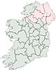
Munster Clare · Cork (Cork City) · Kerry · Limerick (Limerick City) · Tipperary (North Tipperary • South Tipperary) · Waterford (Waterford City)
Leinster Carlow · Dublin (Dublin City • Dún Laoghaire–Rathdown • Fingal • South Dublin) · Kildare · Kilkenny · Laois · Longford · Louth · Meath · Offaly · Westmeath · Wexford · Wicklow
Ulster Italics denote non-administrative counties. Brackets denote eponymous cities or non-traditional counties. † denotes counties of Northern Ireland Categories:- County Louth
- Leinster
- Counties of the Republic of Ireland
- Local administrative units of the Republic of Ireland


Wikimedia Foundation. 2010.