- Carrigaline
Infobox Irish Place
name = Carrigaline
gaeilge = Carraig Uí Leighin
crest
motto =
map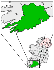
pin coords = left: 129px; top: 69px
north coord = 51.8142
west coord = 8.3925
irish grid = W727625
area =
elevation = 8 m
province =Munster
county =County Cork
town pop = 12,835
rural pop =
census yr = 2006
web = www.carrigaline.ie
|Carrigaline ("Carraig Uí Leighin" in Irish meaning "rock of Lyons") is a single-street
town (or "sráidbhaile") inCounty Cork , Ireland. It is located about 12km from Cork City which can be reached by car in 25 minutes (along the R611 which passes through the town, and then the N28Ringaskiddy –Cork road).Geography
The Owenabue river (sometimes referred to as Owenboy on maps) flows through the village.
Demographics
The population of the town and its hinterland has increased exponentially since the late 1970s when it was identified as a growth centre by Cork County Council. Such growth has occurred with the relentless construction of new housing, mostly semi-detached in estates. The mainly young population, has been stated in a recent publication, as being 12,835 (2006 census) and this is growing by hundreds of people a year with many more houses planned for the area. The village is thus beginning to assume the function of a town, although it does not have its own town council and remains under the authority of Cork County Council. In the most recent census (2006), Carrigaline was recorded as being the town with the second highest proportion of foreign nationals in the county (behind
Midleton ) per head of population, with approximately 900 residents of Eastern European decent, and also a sizable number of Asian and African origin.Transport
*Infrastructural improvements have recently been made with the construction of a Bypass road to the East which allows traffic bound for nearby
Crosshaven (R612) to avoid the congestion of Main Street. A similar road to the West is currently in the late planning stages and construction is expected to begin in 2006. This is expected to facilitate the westward expansion of the village to develop a real town center for the area, which up to now it has lacked. There are also plans at the development stage for the upgrading of the main Cork-Carrigaline road, which also servesRingaskiddy .
* Carrigaline has the highest proportion of workers commuting to work by car in Ireland (74%). [ [http://www.cso.ie/newsevents/pr_prelcen_02vol9.htm CSO] ]
* Nearest airportCork Airport
*Carrigaline was formerly served by the narrow gaugeCork, Blackrock and Passage Railway . The railway station opened on18 June 1903 , but finally closed on1 June 1932 . [cite web | title=Carrigaline station | work=Railscot - Irish Railways | url=http://www.railscot.co.uk/Ireland/Irish_railways.pdf | accessdate=2007-09-15]Economy
The village had a world-famous pottery, situated in the main street. Unusually for an Irish village of its size, it had a small cinema, owned and run by the Cogan family. Neither the pottery or cinema exist today. The Carrigdhoun Weekly newspaper is published here.
The village is twinned with
Guidel inBrittany ,France .port
Locals sports clubs in the area include:
*Carrigaline GAA
* Carrigaline United F.C
* Carrigaline Rugby Club
* Carrigaline Tennis Club
* Carrigaline Basketball Club
* Fernhill Golf and Country Club.ee also
*
Metropolitan Cork
*List of towns in the Republic of Ireland References
External links
* [http://www.carrigaline.ie/ Carrigaline Official Website]
* [http://www.corkcoco.ie/co/web/Cork%20County%20Council/Departments/Infrastructure%20&%20Development/Broadband%20Programme/Broadband%20Locations/Carrigaline Cork County Council - Carrigaline]
* [http://www.carrigcs.ie/ Carrigaline Community School]
* [http://www.carrigalineeducatetogether.ie/ Carrigaline Educate Together Primary School]
* [http://wikimapia.org/s/#y=51811480&x=-8387547&z=13&l=0&m=a/ Satellite image of Carrigaline]
Wikimedia Foundation. 2010.