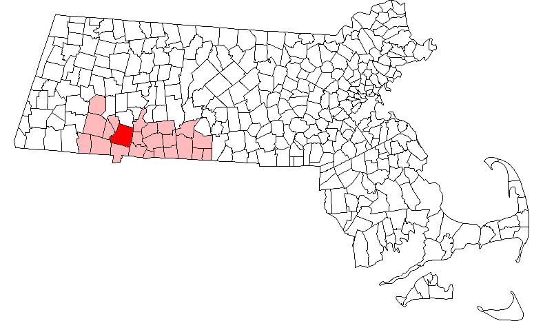
- Westfield, Massachusetts
Infobox Settlement
official_name = Westfield, Massachusetts
settlement_type =City
nickname = The Whip City
motto =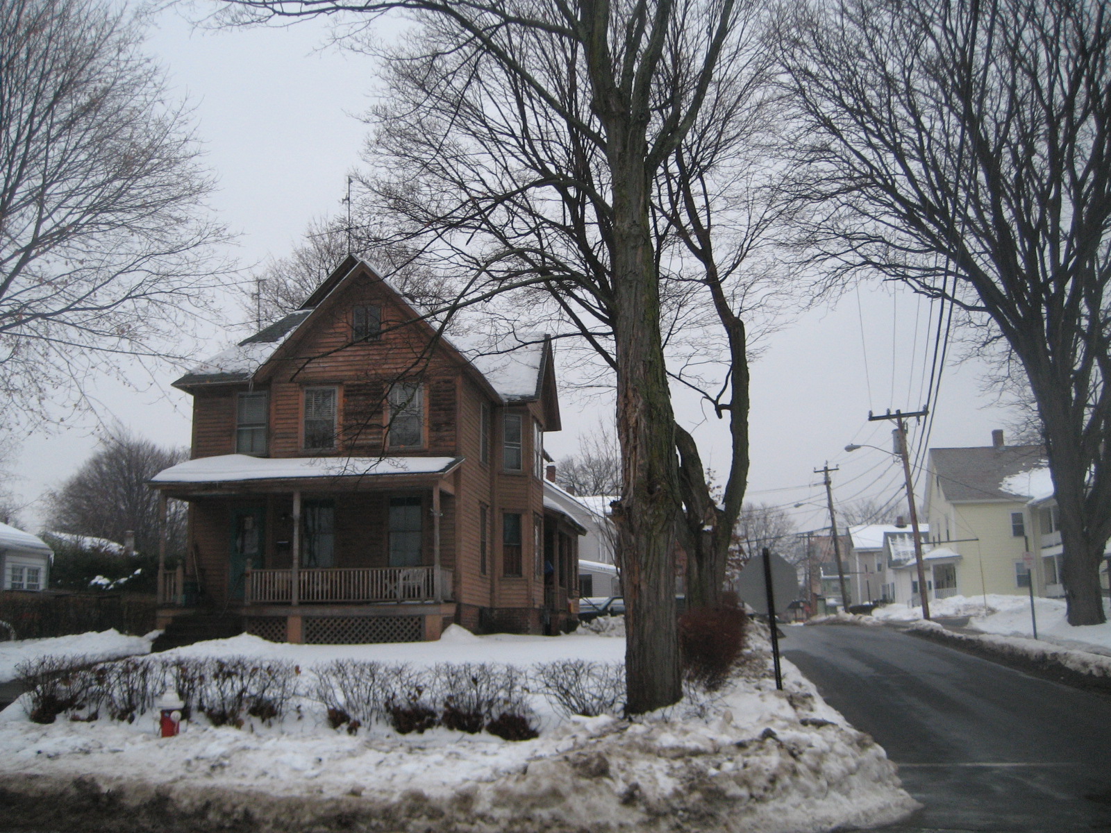
imagesize = 250px
image_caption =
image_
mapsize = 250px
map_caption = Location in Hampden County in Massachusetts
mapsize1 =
map_caption1 =
subdivision_type = Country
subdivision_name =United States
subdivision_type1 = State
subdivision_name1 =Massachusetts
subdivision_type2 = County
subdivision_name2 = Hampden
government_type =
leader_title =Mayor
leader_name = Michael R. Boulanger
established_title = Settled
established_date = 1660
established_title2 = Incorporated (town)
established_date2 =May 19 ,1669
established_title3 = Incorporated (city)
established_date3 =November 2 ,1920
area_magnitude =
area_total_km2 = 122.6
area_total_sq_mi = 47.3
area_land_km2 = 120.6
area_land_sq_mi = 46.6
area_water_km2 = 1.9
area_water_sq_mi = 0.7
area_water_percent = 1.56
area_urban_km2 =
area_urban_sq_mi =
area_metro_km2 =
area_metro_sq_mi =
population_as_of = 2000
population_note =
population_total = 40072
population_density_km2 = 332.2
population_density_sq_mi = 860.3
population_metro =
population_density_metro_km2 =
population_density_metro_sq_mi =
population_urban =
timezone = Eastern
utc_offset = -5
timezone_DST = Eastern
utc_offset_DST = -4
latd = 42 |latm = 07 |lats = 30 |latNS = N
longd = 72 |longm = 45 |longs = 00 |longEW = W
elevation_m = 45
elevation_ft = 148
website = http://www.cityofwestfield.org/
postal_code_type = ZIP codes
postal_code = 01085, 01086
area_code = 413
blank_name = FIPS code
blank_info = 25-76030
blank1_name = GNIS feature ID
blank1_info = 0608962
footnotes =Westfield is a city in Hampden County, in the
Pioneer Valley ofwestern Massachusetts ,United States . It is part of theSpringfield, Massachusetts Metropolitan Statistical Area. The population was 40,072 at the 2000 census. The ZIP Code is 01085 for homes and businesses, 01086 forWestfield State College and U.S. Post Office boxes.History
The area was originally inhabited by the
Pocomtuc tribe, and was called Woronoco (meaning "the winding land" [An Historical Address / Delivered before the citizens of Springfield in Massachusetts at the public celebration May 26 1911 of the Two Hundred and Seventy-Fifth Anniversary of the Settlement with Five Appendices, by Charles H. Barrows. Copyright 1916, Connecticut Valley Historical Society. Thef. A. Bassett Co. Printers, Springfield, Mass. Appendix A, Meaning of Local Indian Names.] ). Trading houses were built in 1639-40 by settlers from theConnecticut Colony . Massachusetts asserted jurisdiction, and prevailed after a boundary survey. In 1647, Massachusetts made Woronoco part ofSpringfield, Massachusetts . [http://www.hampdencountyhistory.com/westfield/wf250/p07.html Chronology of Westfield (1)] Louis M. Dewey, copyright 1905-1919.] Land was incrementally purchased from the Indians and granted by the Springfield town meeting to English settlers, beginning in 1658. The area of Woronoco or "Streamfield" began to be permanently settled in the 1660s. In 1669 (OS), "Westfield" was incorporated as an independent town; [http://www.hampdencountyhistory.com/westfield/wf250/p08.html Chronology of Westfield (2)] Louis M. Dewey, copyright 1905-1919.] in 1920, it would be re-incorporated as a city.From its founding until 1725, Westfield was the westernmost settlement in
Massachusetts Colony . Town meetings were held in a church meeting house until 1839 when Town Hall was erected on Broad Street. This building also served as City Hall from 1920 to 1958. Due to its alluvial lands, the inhabitants of this area were entirely devoted to agricultural pursuits for about 150 years.Early in the 19th century manufacture of bricks, whips, and cigars became economically important. At one point in the 1800s, Westfield was a prominent center of the
buggy whip industry, and the city is still known as the "Whip City." Other firms produced bicycles, paper products, boilers and radiators, textile machinery, abrasives, wood products, and precision tools. Westfield transformed itself from an agricultural town into a thriving industrial city in the 19th century, but in the second half of the 20th century its manufacturing base was eroded by wage competition in the U.S. Southeast, then overseas.Meanwhile, with cheap land and convenient access to east-west and north-south interstate highways, the north side developed into a warehousing center to C & S Wholesale, Home Depot, Lowes and other corporations. South of the river, the intersecting trends of growth of
Westfield State College and declining manufacturing changed the city's character. Students comprise some 15% of Westfield's population and the old downtown business district caters increasingly to them while mainstream shopping relocates to a commercial strip called East Main St., actually part ofU.S. Route 20 .Only four buildings exceed four stories. Until a major fire on January 6, 1952 the Westfield Professional Building covered half a downtown city block and was six stories tall. The entire building was consumed with extensive damage to neighboring buildings because fire department's ladder and snorkel vehicles weren't tall enough and the building did not have a sprinkler system. Subsequent zoning prohibited new construction over three stories, even after improvements in fire suppression technologies and vehicles became available.
In the early 20th century, Westfield was at the center of the Pure Food movement, an effort to require stricter standards on the production of food.
Louis B. Allyn , a Westfield resident and pure foods expert forMcClure's , lived in Westfield until his murder. In 1906, Congress passed thePure Food and Drug Act of 1906 .Geography
Westfield is located at coor dms|42|7|46|N|72|44|46|W|city (42.129492, -72.745986)GR|1. It is bordered on the north by Southampton, on the northeast by Holyoke, on the east by West Springfield, on the southeast by Agawam, on the south by Southwick, on the southwest by Granville, on the west by Russell, and on the northwest by Montgomery. Westfield is split into the "South Side" and the "North Side" by the Westfield River, and the northwestern section of town is known as Wyben.
According to the
United States Census Bureau , the city has a total area of 47.3square mile s (122.6km² ), of which, 46.6 square miles (120.6 km²) of it is land and 0.7 square miles (1.9 km²) of it (1.56%) is water.Westfield is situated at the western edge of the downfaulted
Connecticut River Valley where theWestfield River emerges from the Berkshire Hills and flows through the center of the city on its way to theConnecticut River some ten miles (15 km) downstream. Because of its large, steep and rocky upstream watershed the river has a history of severeflood episodes, inundating adjacent parts of Westfield several times. In spite of a complicated system of pumps, dikes, waterways, and upstream dams, Westfield lies in afloodplain zone and is still considered flood prone.Westfield is bordered on the east by linear cliffs of volcanic
traprock known as East Mountain andProvin Mountain . They are part of theMetacomet Ridge , a mountainoustraprock ridgeline that stretches fromLong Island Sound to nearly theVermont border. Both are traversed by the 110 mileMetacomet-Monadnock Trail .Westfield is on the fringe of the greater
BosWash urban corridor -- the most densely populated region of the United States -- and has experienced substantial land development for suburban residential and commercial uses for the past six decades. Yet it borders "Hilltowns" to the west that were depopulated of subsistence farmers in the 1800s as land became readily available on the western frontier. With population dipping below ten per square kilometer in some upland townships, forests are reverting almost to pre-settlement conditions withwild turkey ,bears ,coyotes and evenmoose returning after absences perhaps measured in centuries. This transition over a few kilometers from 21st century urbanization to nearly those of early colonial times is notable if not unique.Demographics
USCensusPop
1930=16684
1940=18793
1950=20962
1960=26302
1970=31433
1980=36465
1990=38372
2000=40072
footnote=historical data source: [cite web
url=http://www.ci.newton.ma.us/Planning/Demogr/population1930-1990.pdf
title=Population of Massachusetts Cities, Towns and Counties, 1930-1998] As of thecensus GR|2 of 2000, there were 40,072 people, 14,797 households, and 10,017 families residing in the city. Thepopulation density was 860.3 people per square mile (332.2/km²). There were 15,441 housing units at an average density of 331.5/sq mi (128.0/km²). The racial makeup of the city was 94.53% White, 0.91% African American, 0.22% Native American, 0.82% Asian, 0.05% Pacific Islander, 2.12% from other races, and 1.34% from two or more races. Hispanic or Latino of any race were 5.01% of the population.Westfield has long been a multicultural city with significant enclaves of Italians, Irish, Poles, French Canadians and Puerto Ricans. Since 1991 Westfield has welcomed Ukrainians and Russians (often by way of other republics such as
Kazakhstan ). Especially prominent are fundamentalist Protestants who were persecuted for their lack of atheist zeal under Communism, then encountered more problems as new governments sought to restore theRussian Orthodox Church -- or Islam in Central Asia -- while trying to suppress "western" denominations.There were 14,797 households out of which 31.5% had children under the age of 18 living with them, 53.0% were married couples living together, 10.6% had a female householder with no husband present, and 32.3% were non-families. 25.9% of all households were made up of individuals and 10.9% had someone living alone who was 65 years of age or older. The average household size was 2.54 and the average family size was 3.07.
In the city the population was spread out with 23.8% under the age of 18, 12.6% from 18 to 24, 28.0% from 25 to 44, 21.9% from 45 to 64, and 13.7% who were 65 years of age or older. The median age was 36 years. For every 100 females there were 93.7 males. For every 100 females age 18 and over, there were 90.8 males.
The median income for a household in the city was $45,240, and the median income for a family was $55,327. Males had a median income of $38,316 versus $27,459 for females. The
per capita income for the city was $20,600. About 6.9% of families and 11.3% of the population were below thepoverty line , including 16.2% of those under age 18 and 9.5% of those age 65 or over.Government
Westfield is governed by a mayor and a city council, elected every two years. The Office of the Mayor is responsible for a variety of services throughout the city and the mayor also serves as Chairman of the School Committee. The City Council meets the 1st and 3rd Thursday of every month at 7:30 in City Hall.
The current mayor of Westfield is Michael R. Boulanger.
Education
Westfield's [http://www.k12.westfield.ma.us/ public school system] consists of two
preschool s, eightelementary school s, twomiddle school s and twohigh school s.Preschools
* [http://www.k12.westfield.ma.us/fort/index.html Fort Meadow School]
* [http://www.k12.westfield.ma.us/headstart/ Westfield Area Head Start]Elementary schools
* [http://www.k12.westfield.ma.us/ag/index.html Abner Gibbs Elementary School]
* [http://www.k12.westfield.ma.us/fa/INDEX.HTM Franklin Avenue Elementary School]
* [http://www.k12.westfield.ma.us/hlnd/index.html Highland Elementary School]
* [http://www.k12.westfield.ma.us/jp/index.htm Juniper Park Elementary School]
* [http://www.k12.westfield.ma.us/mos/index.html Moseley Elementary School]
* [http://www.k12.westfield.ma.us/mh/index.htm Munger Hill Elementary School]
* [http://www.k12.westfield.ma.us/pm/index.html Paper Mill Elementary School]
* [http://www.k12.westfield.ma.us/sr/index.html Southampton Road Elementary School]Middle schools
* [http://www.k12.westfield.ma.us/sms/index.html South Middle School]
* [http://www.k12.westfield.ma.us/nms/index.htm North Middle School]High schools
* [http://www.k12.westfield.ma.us/whs/index.html Westfield High School]
* [http://wvths.com/ Westfield Vocational-Technical High School]Private schools
* [http://www.diospringfield.org/~stmaryeswsfd/ St. Mary Elementary School]
* [http://www.diospringfield.org/~stmaryhswsfd/ St. Mary High School]Higher education
The city is also home to
Westfield State College .Media
*Westfield Evening News/Pennysaver
*PREDVESTNIK, The Russian Language Newspaper, ( [http://www.predvestnik.com Official website] )Transportation
Major highways
The
Massachusetts Turnpike crosses Westfield just north of the central business district. The "Mass Pike" is part ofI-90 extending east toBoston and west to Albany, Buffalo,Cleveland ,Chicago , and across theUpper Midwest ,Wyoming ,Montana andIdaho to Spokane andSeattle . About five kilometers east of Westfield, the turnpike intersectsI-91 which generally follows theConnecticut River Valley south toSpringfield ,Hartford andNew Haven or north toCanada (Quebec ).Westfield's main north-south thoroughfare is US 202/Route 10, which includes parts of Southwick Rd., S. Maple St., W. Silver St., Pleasant St., Court St., Broad St., Elm St., North Elm St., and Southampton Rd. At the intersection of Southampton Rd. and North Rd., Rte. 10 continues on Southampton Rd. toward Southampton while US 202 follows North Rd. toward Holyoke.
Apart from limited-access I-90, the main east-west thoroughfare is US 20, which includes parts of Russell Rd., Franklin St., Elm St., Main St., E. Main St., and Springfield Rd. Route 187 also ends in Westfield. Other main roads include Western Ave., Granville Rd., Union St., and Montgomery Rd. East Mountain Rd. is the longest road in Westfield.
Great River Bridge project
A notable choke point for north/south travel is the Great River Bridge over the
Westfield River . This is a three lane throughtruss bridge . Currently (August 2007), there is an active project to create a second bridge just to the east (downstream). The new bridge will be a similar through-truss bridge with two spans totaling convert|368|ft. [Phone call to MassHighway District 2 engineer on 2008-06-25] After the second bridge is completed the existing bridge will be refurbished; then each bridge will carry traffic in one direction. A large property taking on the east side of North Elm Street cleared the way for the new bridge.Rail
Westfield is at the junction of the east-west
Boston and Albany Railroad and a north-south spur of theNew York, New Haven and Hartford Railroad . There is no more passenger service, however Pioneer Valley Railroad andCSX provide freight service. More than 35 motor freight carriers with nearby terminals provide competitive freight service locally and to all distant points.Bus
The city is presently served by two PVTA bus routes to Springfield and Holyoke. Bus and rail service to all points is available at Springfield.
Air
Barnes Municipal Airport in Westfield has charter passenger services.Bradley International Airport atWindsor Locks, Connecticut within 30 minutes driving time has scheduled flights by most airlines.Albany International Airport is a practical alternative to Bradley -- similar flight offerings and about a one hour drive west via I-90.Points of interest
* [http://www.ameliapark.org/ Amelia Park Arena]
*Stanley Park of Westfield
* TheMetacomet-Monadnock Trail
* East MountainNotable residents
*
Edward Bancroft (1744–1821) physician and double agent in the American Revolution
*Emma Helen Blair (1851—1911) historian, journalist and editor who attended high school in town
*Lou Barlow (b. 1966), alternative rock singer, songwriter, musician
*Asahel Bush (1824-1913), printer and publisher the "Oregon Statesman" newspaper; His estate is now preserved asBush's Pasture Park and his home, Asahel Bush House, is on the National Register of Historic Places
*Ray Fitzgerald (] 1904] -1977), Major League Baseball player who died in town
*Frederick H. Gillett (1851–1935), U.S. Congressman, Speaker of the U.S. House of Representatives
*Manuel Gonzales (1913-1993), comics artist
*Ferdinand Vandeveer Hayden (1829–1887) pioneering geologist
*Thomas Ingersoll (1749 – 1812), early settler ofIngersoll, Ontario , and for whom that town is named
*Michael Kelley formerly of the NFL, who played for the Houston Oilers, and the Philadelphia Eagles
*Jackie French Koller , author and painter
*Walt Kowalczyk (b. 1935), professional football player with the Philadelphia Eagles, Dallas Cowboys and Oakland Raiders
*Jesse Leach , rock singer and musician
*Kay Life , artist, children's book illustrator
*Don Pardo , television announcer
*Gorham Parks , U.S. Congressman fromMaine and American Consul inRio de Janeiro
*Frederic Rzewski , composer
*Sebadoh , indie rock band
*Walter Scott Story (1879-1955), author
*Edward Taylor (c. 1642–1729) poet, physician, and pastor
*Mark Trafton , U.S. Congressman
*Stephen Albano artist, musician
*Chris Hart - 2007 Massachusetts State Champion of the National Geographic Society National Geography Bee [ [http://press.nationalgeographic.com/pressroom/index.jsp?pageID=pressReleases_detail&siteID=1&cid=1175799163368 National Geographic Society Press Room: Press Release Detail ] ]Bands from Westfield
*
Killswitch Engage , metalcore rock band
*Sebadoh , indie rock band
*Steve Westfield and the Slow Band , indie rock band
*Pajama Slave Dancers , indie rock/punk band
*S.M.A. , ska/rock bandReferences
* http://www.cityofwestfield.org
External links
* [http://www.cityofwestfield.org/ Official Site]
* [http://www.wsc.mass.edu/ Westfield State College]
* [http://www.westath.org/about/about.htm Westfield Athenaeum] , the library in Westfield
* Westfield is home to Barnes Airport, which hosts [http://www.mabarn.ang.af.mil/history.htm/ The 104th Fighter Wing]
* [http://www.hampdencountyhistory.com/westfield/wfvr/index.html/ A Record of Marriages, Births and Deaths in Westfield, Massachusetts Prior to the Year 1700 - Communicated by the Rev. Emerson Davis of that town, Corresponding Member of the New England Historic-Genealogical Society]
Wikimedia Foundation. 2010.