- West Brookfield, Massachusetts
-
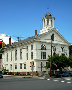
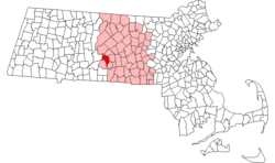
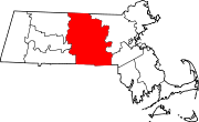
West Brookfield, Massachusetts — Town — Town Hall Location in Worcester County in Massachusetts Coordinates: 42°14′07″N 72°08′30″W / 42.23528°N 72.14167°WCoordinates: 42°14′07″N 72°08′30″W / 42.23528°N 72.14167°W Country United States State Massachusetts County Worcester Settled 1664 Incorporated 1848 Government – Type Open town meeting Area – Total 21.1 sq mi (54.7 km2) – Land 20.5 sq mi (53.0 km2) – Water 0.6 sq mi (1.7 km2) Elevation 633 ft (193 m) Population (2010) – Total 3,701 – Density 175.2/sq mi (67.7/km2) Time zone Eastern (UTC-5) – Summer (DST) Eastern (UTC-4) ZIP code 01585 Area code(s) 508 / 774 FIPS code 25-75400 GNIS feature ID 0618392 Website http://www.wbrookfield.com/ West Brookfield is a town in Worcester County, Massachusetts, United States. The population was 3,701 at the 2010 census. Lucy Stone was born in West Brookfield, and Noah Webster published his dictionary there.
For geographic and demographic information on the census-designated place West Brookfield, please see the article West Brookfield (CDP), Massachusetts.
Contents
History
West Brookfield was first settled in 1664 and was officially incorporated in 1848, splitting off from Brookfield.
The town is believed to be the birthplace of asparagus in the New World. Diederik Leertouwer came to the United States in 1784 to promote trade between the Netherlands and New England. He later settled with his wife and daughter in West Brookfield where he carried out his duties as Consul and lived here between the years 1794 and 1798. At that time West Brookfield had a population greater than Worcester and was being considered for the county seat. Local legend has it that Diederik Leertouwer imported asparagus from his homeland and was the first to plant it in this area. This fact was forgotten until it was discovered in an old cookbook. Wild asparagus still grows in this area today. Leertouwer died here and is buried in the Old Indian Cemetery on Cottage Street in West Brookfield.[1]
The town is also home to the Rock House Reservation, a massive, cave-like rock shelter, exposed after the glacial retreat 10,000 years ago, that served as a winter camp for Native Americans. By the mid 1800s, it was part of a farm owned by William Adams whose descendant, F. A. Carter, dammed a small stream to create Carter Pond and built the cottage now serving as a trailside museum and nature center. The reservation is open year round, daily, sunrise to sunset. Admission is free to all.[2]
Geography
According to the United States Census Bureau, the town has a total area of 21.1 square miles (55 km2), of which 20.5 square miles (53 km2) is land and 0.6 square miles (1.6 km2), or 3.03%, is water. West Brookfield is bounded on the southeast by Brookfield, on the north by North Brookfield, on the north by New Braintree, on the west by Ware and on the southwest by Warren.
Demographics
Historical populations Year Pop. ±% 1850 1,344 — 1860 1,548 +15.2% 1870 1,842 +19.0% 1880 1,917 +4.1% 1890 1,592 −17.0% 1900 1,448 −9.0% 1910 1,327 −8.4% 1920 1,281 −3.5% 1930 1,255 −2.0% 1940 1,387 +10.5% 1950 1,674 +20.7% 1960 2,053 +22.6% 1970 2,653 +29.2% 1980 3,026 +14.1% 1990 3,532 +16.7% 2000 3,804 +7.7% 2001* 3,883 +2.1% 2002* 3,907 +0.6% 2003* 3,925 +0.5% 2004* 3,918 −0.2% 2005* 3,911 −0.2% 2006* 3,900 −0.3% 2007* 3,905 +0.1% 2008* 3,845 −1.5% 2009* 3,859 +0.4% 2010 3,701 −4.1% * = population estimate.
Source: United States Census records and Population Estimates Program data.[3][4][5][6][7][8][9][10][11][12]As of the census[13] of 2000, there were 3,804 people, 1,362 households, and 965 families residing in the town. The population density was 185.8 people per square mile (71.8/km²). There were 1,534 housing units at an average density of 74.9 per square mile (28.9/km²). The racial makeup of the town was 98.16% White, 0.32% Black or African American, 0.24% Native American, 0.24% Asian, 0.05% Pacific Islander, 0.16% from other races, and 0.84% from two or more races. Hispanic or Latino of any race were 1.05% of the population.
There were 1,362 households out of which 33.6% had children under the age of 18 living with them, 59.4% were married couples living together, 8.7% had a female householder with no husband present, and 29.1% were non-families. 23.6% of all households were made up of individuals and 10.4% had someone living alone who was 65 years of age or older. The average household size was 2.53 and the average family size was 3.01.
In the town the population was spread out with 22.9% under the age of 18, 5.3% from 18 to 24, 25.7% from 25 to 44, 25.1% from 45 to 64, and 20.9% who were 65 years of age or older. The median age was 43 years. For every 100 females there were 81.7 males. For every 100 females age 18 and over, there were 78.3 males.
The median income for a household in the town was $49,722, and the median income for a family was $58,750. Males had a median income of $41,211 versus $29,783 for females. The per capita income for the town was $21,501. About 4.0% of families and 6.8% of the population were below the poverty line, including 9.9% of those under age 18 and 4.6% of those age 65 or over.
Government
County government: Worcester County Clerk of Courts: Dennis P. McManus (D) District Attorney: Joseph D. Early, Jr. (D) Register of Deeds: Anthony J. Vigliotti (D) Register of Probate: Stephen Abraham (D) County Sheriff: Lew Evangelidis (R) State government State Representative(s): Anne M. Gobi (D) State Senator(s): Stephen M. Brewer (D) Governor's Councilor(s): Jen Caissie (R) Federal government U.S. Representative(s): John W. Olver (D-1st District), U.S. Senators: John Kerry (D), Scott Brown (R) Library
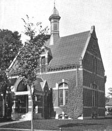
The Merriam-Gilbert Public Library was built in 1880 when Charles Merriam (born in West Brookfield in 1806), famous for publishing the first Webster's Dictionary, provided the funding for the structure. After seven months of construction, the building was dedicated as the Merriam Public Library and Reading Room. The Library was eventually re-dedicated in 1960 as the Merriam-Gilbert Public Library after it received an unexpected and generous bequest from Helen E. Gilbert, a former West Brookfield native.
The exterior of the Library remains relatively unchanged with the exception of a cupola, which was destroyed in the Hurricane of '38. Also, an elevator tower was discreetly added during the 1997 building renovation project that both refurbished and made the building accessible to the handicapped.[14]
In fiscal year 2008, the town of West Brookfield spent 3.11% ($167,532) of its budget on its public library—some $44 per person.[15]
Education
There is one public school in West Brookfield, West Brookfield Elementary School, serving grades K-6. West Brookfield is regionalized with Warren; students in grades 7-12 from both towns attend Quaboag Regional Middle-High School in Warren.
Notable residents
- Lucy Stone, prominent American suffragist
- Jedediah Foster, one of the three original drafters of the Massachusetts Constitution
- Daniel Henry Chamberlain, 76th Governor of South Carolina
References
- ^ "The Legend of Diederick Leertouwer and Asparagus in New England." Diederick Leertouwer. West Brookfield Historical Commission, 5/1/2009. Web. 7 Nov 2011. <http://www.westbrookfield.org/history-of-asparagus.htm>.
- ^ "Rock House Reservation." West Brookfield Historical Commission. West Brookfield Historical Commission, 25 Oct 2006. Web. 8 Nov 2011. <http://www.westbrookfield.org/rockhouse.htm>.
- ^ "TOTAL POPULATION (P1), 2010 Census Summary File 1, All County Subdivisions within Massachusetts". United States Census Bureau. http://factfinder2.census.gov/bkmk/table/1.0/en/DEC/10_SF1/P1/0400000US25.06000. Retrieved September 13, 2011.
- ^ "Massachusetts by Place and County Subdivision - GCT-T1. Population Estimates". United States Census Bureau. http://factfinder.census.gov/servlet/GCTTable?_bm=y&-geo_id=04000US25&-_box_head_nbr=GCT-T1&-ds_name=PEP_2009_EST&-_lang=en&-format=ST-9&-_sse=on. Retrieved July 12, 2011.
- ^ "1990 Census of Population, General Population Characteristics: Massachusetts". US Census Bureau. December 1990. Table 76: General Characteristics of Persons, Households, and Families: 1990. 1990 CP-1-23. http://www.census.gov/prod/cen1990/cp1/cp-1-23.pdf. Retrieved July 12, 2011.
- ^ "1980 Census of the Population, Number of Inhabitants: Massachusetts". US Census Bureau. December 1981. Table 4. Populations of County Subdivisions: 1960 to 1980. PC80-1-A23. http://www2.census.gov/prod2/decennial/documents/1980a_maABC-01.pdf. Retrieved July 12, 2011.
- ^ "1950 Census of Population". Bureau of the Census. 1952. Section 6, Pages 21-10 and 21-11, Massachusetts Table 6. Population of Counties by Minor Civil Divisions: 1930 to 1950. http://www2.census.gov/prod2/decennial/documents/23761117v1ch06.pdf. Retrieved July 12, 2011.
- ^ "1920 Census of Population". Bureau of the Census. Number of Inhabitants, by Counties and Minor Civil Divisions. Pages 21-5 through 21-7. Massachusetts Table 2. Population of Counties by Minor Civil Divisions: 1920, 1910, and 1920. http://www2.census.gov/prod2/decennial/documents/41084506no553ch2.pdf. Retrieved July 12, 2011.
- ^ "1890 Census of the Population". Department of the Interior, Census Office. Pages 179 through 182. Massachusetts Table 5. Population of States and Territories by Minor Civil Divisions: 1880 and 1890. http://www2.census.gov/prod2/decennial/documents/41084506no553ch2.pdf. Retrieved July 12, 2011.
- ^ "1870 Census of the Population". Department of the Interior, Census Office. 1872. Pages 217 through 220. Table IX. Population of Minor Civil Divisions, &c. Massachusetts. http://www2.census.gov/prod2/decennial/documents/1870e-05.pdf. Retrieved July 12, 2011.
- ^ "1860 Census". Department of the Interior, Census Office. 1864. Pages 220 through 226. State of Massachusetts Table No. 3. Populations of Cities, Towns, &c.. http://www2.census.gov/prod2/decennial/documents/1860a-08.pdf. Retrieved July 12, 2011.
- ^ "1850 Census". Department of the Interior, Census Office. 1854. Pages 338 through 393. Populations of Cities, Towns, &c.. http://www2.census.gov/prod2/decennial/documents/1850c-11.pdf. Retrieved July 12, 2011.
- ^ "American FactFinder". United States Census Bureau. http://factfinder.census.gov. Retrieved 2008-01-31.
- ^ "About the Library." Merriam-Gilbert Public Library. Merriam-Gilbert Public Library, 4 Nov 2011. Web. 8 Nov 2011. <http://www.wbrookfieldlibrary.org/about.html>.
- ^ July 1, 2007 through June 30, 2008; cf. The FY2008 Municipal Pie: What’s Your Share? Commonwealth of Massachusetts, Board of Library Commissioners. Boston: 2009. Available: Municipal Pie Reports. Retrieved 2010-08-04
External links
Categories:- Towns in Worcester County, Massachusetts
Wikimedia Foundation. 2010.


