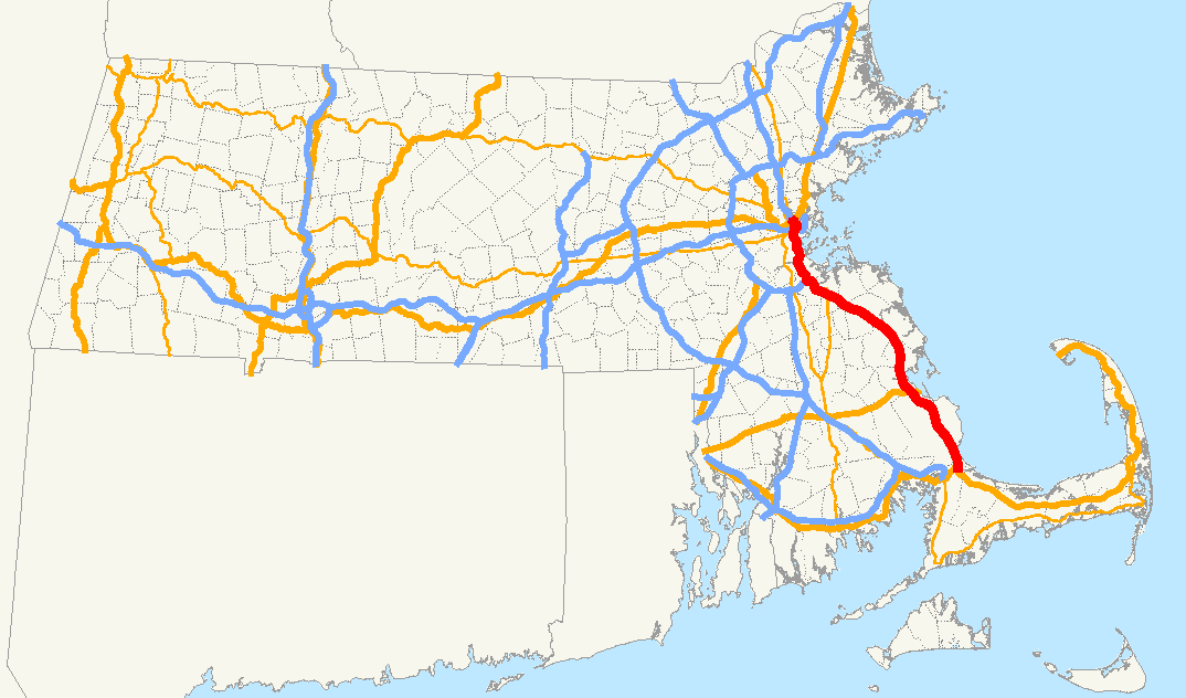
- Massachusetts Route 3
-
- For the U.S. Route that continues (State) Route 3 north into New Hampshire, see U.S. Route 3. For the Route 3 that existed in the early 1920s, see U.S. Route 6 in Massachusetts.
Route 3

Route information Length: 55.7059 mi[1] (89.6500 km) Existed: 1926 – present Major junctions South end:  US 6 in Bourne
 US 44 in Plymouth

 I-93/US 1 in Braintree
North end: 
 US 3/Route 2A in Cambridge[1]
Location Counties: Barnstable, Plymouth, Norfolk, Suffolk, Middlesex Highway system Massachusetts State Highway Routes
← US 3Route 3A  →
→Route 3 is a southward continuation of U.S. Route 3, connecting Cambridge, Massachusetts with Cape Cod. All of it, except for the northernmost end in downtown Boston and Cambridge, is a freeway.
The section from Boston to Braintree is also marked as Interstate 93 and U.S. Route 1 and is known in downtown Boston as the Central Artery, and south of downtown as the Southeast Expressway. In Braintree, I-93 and US 1 split to follow the Yankee Division Highway to Interstate 95, and Route 3 continues south on its own, as the Pilgrims Highway. This section extends to a junction with U.S. Route 6 in Sagamore, just before the Sagamore Bridge over the Cape Cod Canal where Route 3 originally ended at rotary. Replacement of this rotary with a grade-separated interchange was completed in November 2006.
Because Route 3 and U.S Route 3 are treated as the same route by the Massachusetts Department of Transportation (MassDOT), mileposts increase continuously from Bourne to the New Hampshire border.
Contents
Route description
Route 3 can be said to have three segments; the Pilgrims Highway, its concurrency with Interstate 93, and its route after leaving I-93 in Boston and Cambridge.
Pilgrims Highway
Pilgrims Highway is the part of Route 3 that stretches from the intersection with US 6 in Bourne to the junction with Interstate 93 in Braintree.
Interstate 93
Route 3 runs concurrently with Interstate 93 and U.S. Route 1 from Exit 7 in Braintree to Exit 26 in Boston. See Interstate 93.
Downtown Boston and Cambridge
Route 3 exits I-93 at Exit 26, passes through Leverett Circle, and runs for a short way along the Charles River to the Longfellow Bridge where it crosses over to Cambridge and joins Memorial Drive. It is on Memorial Drive that the designation changes to US-3 which continues northward toward New Hampshire.
History

Route 3 began as a new designation for New England Highway 6 in 1927 when the U.S. Highway system was created and New England highway Route 3 was chosen to be US 6. The former NE 6 then took the route 3 number with U.S. Route 3 designated north of its intersection with U.S. Route 1 and Massachusetts Route 3 to the south. The route was basically a connected system of two-lane roadways up until the 1950s with the exception of Route 3's original path through Boston which paired it with US 1 on Park Drive, the Riverway and the Jamaicaway and then along its own path in Mattapan and Dorchester along the Arborway, Morton Street and Gallivan Boulevard.
 A portion of the Pilgrims Highway in Plymouth
Before the road was rerouted, the road continued over the Cape Cod Canal via the Sagamore Bridge to the Bourne Rotary, to the south of the Bourne Bridge. This arrangement changed after 1951.
The Plimoth Plantation Highway, a two-lane expressway that connects Route 3 with Route 3A, was once signed as Route 3 before the southernmost portion of the freeway to Cape Cod was finished.
The first section of the Pilgrims Highway was built as a bypass of Plymouth in the early 1950s. The mid-1950s saw an extension of this bypass route south to the Sagamore Bridge and north to Kingston. The northern section of the highway was built next with a connection from Derby Street in Hingham to the Southeast Expressway opening in 1959. (Portions of this road run alongside the Old Colony Railroad's mainline, now used by the MBTA Old Colony Lines Commuter Rail, and the MBTA Red Line rapid transit.) Finally the last sections between Hingham and Duxbury were completed by 1963 when the Route 3 designation was moved onto the completed freeway. The former Route 3 highways became Route 3A in Quincy and from Kingston south, the remainder became Route 53. Route 3 was connected to the Southeast Expressway in Milton by using Granite Avenue as a link from Gallivan Boulevard. Until around 1965, the northern portion of the Pilgrims Highway, from current Exit 15 (Derby Street) in Hingham, was also signed as Route 128, which continued past the exit on surface streets to Hull. However, by 1966 the 128 designation was removed past its intersection with Route 3 in Braintree (and thus from the Pilgrims Highway entirely) and the surface portion became Massachusetts Route 228. Route 3 was then taken off its remaining pathway along surface streets in Boston and extended up the Southeast Expressway and Central Artery in 1971 to the Storrow Drive exit. The routing of Route 3 has changed little since that time.
A re-signing project from 2006 to 2009 changed exit 20 to exit 20A for I-93 south and exit 20B for I-93 north. In the process, the ramp carrying Route 3 to I-93 north was no longer signed as part of Route 3. Separate signs indicating Route 3's routing along I-93 were installed on exit sign support poles in 2011.[2]
The MassDOT is currently looking in to the possibility of widening Route 3 from I-93 to the Sagamore Bridge from four to six lanes with new bridges and new on- and off-ramps, and will include upgraded interchanges with new acceleration and deceleration lanes. The project is expected to cost $256 million.
Exit list
County Location Mile marker # Destinations Notes Barnstable Bourne 0.1 1A US 6 west (Scusset Beach Road) – Buzzards Bay, FalmouthSplit into two exits Northbound: Northbound Exit 1A leads to Eastbound Scusset Beach Road; the exit for Route 6 Westbound is unnumbered Northbound 0.3 1B US 6 east – Sagamore, Hyannis0.0 1C  Route 6A – Sagamore
Also Exit 1C off of Route 6 Plymouth Plymouth 2.5 2 Route 3A (Herring Pond Road) – Cedarville, ManometSouthern terminus of Route 3A 7.1 3 Clark Road, Beaver Dam Road – Pine Hills Former control locations: Myles Standish State Forest, Long Pond. 12.3 4 Plimoth Plantation Highway – Manomet Partial interchange: southbound exit and northbound entrance only. 12.7 5 Long Pond Road, South Street – Plymouth Center Former control locations: Myles Standish State Forest, College Pond 14.5 6 US 44 east (Samoset Street) – Plymouth Center, CarverSouth end of US 44 overlap; signed as exits 6A (east) and 6B (west) southbound 15.6 7 US 44 west – Taunton, ProvidenceNorth end of US 44 overlap Kingston 16.9 8 Smith Lane – Rocky Nook To Independence Mall Way 17.8 9 Route 3A – Kingston, North PlymouthTo 

 Routes 80, 106, and 27 via Route 3A north.
Duxbury 19.4 10  Route 3A to Route 53 – Kingston, South Duxbury
22.3 11  Route 14 – Duxbury, Pembroke
Pembroke 26.9 12  Route 139 – Marshfield, Hanover
Pembroke was a former control location southbound. Hanover 31.7 13  Route 53 to Route 123 – Hanover, Norwell
To Hanover Mall Drive Rockland 34.3 14  Route 228 – Hingham, Rockland
Southern end of Route 228
Secondary control location: Nantasket.
Cohasset was a former secondary control location.Hingham 36.1 15 Derby Street, Hingham, Weymouth To Route 53, Norwell (southbound). Northbound sign removed by 13 July 2009.Norfolk Weymouth 38.1 16  Route 18 – Weymouth, Abington
Signed as exits 16A (north) Weymouth and 16B (south) Abington, southbound. South Weymouth is signed as a primary control location northbound and as a secondary control location southbound (16B). Braintree 40.5 17 Union Street – Braintree, South Braintree 42.7 18 Washington Street – Braintree Southbound exit and northbound entrance 42.0 (NB)
42.4 (SB)19 Burgin Parkway, Quincy Center, Quincy Adams MBTA Station Signed as exits 19/18 southbound, former exit 18 ramp serves both Burgin Pkwy and Washington St 42.6 20A TO  I-93 south / US 1 south to I-95 - Canton*
42.6 20B I-93 north / US 1 – Boston*South end of I-93/US 1/Route 3 overlap *Initial signs do not include US 1, however, plans are to add this route to the signs later on See I-93 (exits 7-24) Suffolk Boston 53.5 26 
 Route 3/Route 28
Storrow Drive-Cambridge-North StationNorth end of I-93/US 1 overlap North end of freeway 54.1 Route 28 North - Leverett CircleSouth end of Route 28 overlap; interchange northbound and at-grade intersection southbound 54.4 Cambridge Street - to Government Center, Massachusetts General Hospital Route 3 leaves Storrow Drive Longfellow Bridge over the Charles River Middlesex Cambridge 55.0 Main Street – Kendall Square Interchange; southbound exit is via a left turn at Wadsworth Street 55.3 Land Boulevard to Expressways – Charlestown 55.6 Route 2A - Massachusetts Ave./Harvard BridgeRamp to direct access to Mass Ave - Route 3 continues below grade 55.7 U.S. Route 3Route 3 continues as US 3 west of Harvard Bridge. Former exit numbers
Route 3 was one of the freeways whose exits were once numbered with the "25 is 128" system, in which the Braintree Split was numbered "Exit 25" (due to it being the exit for Route 128), with numbers increasing away from Boston and decreasing toward Boston. Under the old system, the Sagamore Rotary was (on paper) "Exit 43". When the first 22 miles (35 km) of the highway were resurfaced in 1975-76, the new numbers were instituted in that section. When the Braintree section was resurfaced in 1978, the rest of the new numbers were posted, leaving a two-year gap when half the highway was on the new system while the other half was on the old system. During that time, the exit to Route 14 was "Exit 11" northbound and "Exit 33" southbound.
References
- Pilgrims Highway (MA 3) on Bostonroads.com
- 1952 Shell Oil Sectional Map No. 1, New England States
- 1960 AAA Map of Southern New England
- 1966 ESSO New England Map
- 1971 ESSO Southern New England Map
- Responses to post by Bob Malme on newsgroup ne.transportation titled "MA Roadtrip Observations" posted 6/28/07.
- ^ a b Executive Office of Transportation, Office of Transportation Planning - 2005 Road Inventory. AASHTO however lists the end of US 3 at US 20 after it crosses the BU Bridge from Memorial Drive. If US 3 now ends at MA 2A, this has not been officially approved by that organization and MassHighway has yet to apply for this change.
- ^ Personal e-mail from Stephen Timmins, Mass. Highway Department Route 3 sign replacement project engineer, January 20, 2011
External links
Road transportation infrastructure of Cape Cod U.S. Routes  State Routes
State Roads Bridges See also: Cape Cod Canal Tunnel · Southside ConnectorCategories:- Braintree, Massachusetts
- Duxbury, Massachusetts
- Freeways in the United States
- Kingston, Massachusetts
- Numbered routes in Massachusetts
- Plymouth, Massachusetts
- Pembroke, Massachusetts
- Marshfield, Massachusetts
- Norwell, Massachusetts
- Hanover, Massachusetts
- Rockland, Massachusetts
- Hingham, Massachusetts
- Weymouth, Massachusetts
- Quincy, Massachusetts
- Milton, Massachusetts
- Transportation in Boston, Massachusetts
- Cambridge, Massachusetts
- Transportation in Plymouth County, Massachusetts
- Transportation in Norfolk County, Massachusetts
- Transportation in Suffolk County, Massachusetts
- Transportation in Middlesex County, Massachusetts


Wikimedia Foundation. 2010.