- Massachusetts Route 6A
-
Route 6A

Route information Length: 62.4637 mi[1] (100.5256 km) Existed: ca. 1950 – present Major junctions West end:  U.S. Route 6 in Bourne
(continues as Sandwich Road) Route 132 in Barnstable
U.S. Route 6 in Orleans
 Route 28 in Orleans
U.S. Route 6 in Eastham
U.S. Route 6 in TruroNorth end: U.S. Route 6 in ProvincetownHighway system Massachusetts State Highway Routes
← US 6US 7  →
→

In Barnstable Village Route 6A is the name for parts of former U.S. Route 6 on Cape Cod. Most of "6A", as the locals call it, is also known as the Old King's Highway. Combining the 2 major sections (and the apparent "silent concurrency" with US-6 through Eastham, Wellfleet, and South Truro), the highway is approximately 62 miles (100 km) long.
Contents
Route description
Although some maps have Route 6A starting at the Bourne Bridge Rotary along Sandwich Road, it actually starts some feet east of the Sagamore Bridge, according to state signage. From there, it goes thus:
- Bourne: Sandwich Road
- Sandwich: Route 6A
- Barnstable: Main Street
- Yarmouth: Main Street
- Dennis: Kings Highway
- Brewster: Main Street
- Orleans: Cranberry Highway
- Truro: Shore Road
- Provincetown: Commercial Street (1 mile), Bradford Street (2.5 miles), Provincelands Road (1 mile)
Since 1982, Route 6A has ended at an intersection (signalized until 2010) with US 6 at Herring Cove, part of the Cape Cod National Seashore. Before 1982, the intersection was a large complicated rotary-like design, and 6A ran slightly more north than its intersection with US 6, ending at the exit off the rotary for the remainder of Provincelands Road toward Race Point.
It is signed East and West between Bourne and Orleans, and signed North and South in Truro and Provincetown.
Some maps erroneously had the northern Route 6A having its southern terminus at US-6 along Mayflower Avenue in Provincetown. However, since Mayflower Avenue is an extremely narrow private road of questionable maintenance, and there is no access from East US-6 to Mayflower Avenue, the reason for this misunderstanding was unknown. This has since been fixed in most maps which once contained this error.
Some maps also erroneously mark US 6's old routing through downtown Wellfleet as Route 6A, though MassHighway (and the Massachusetts Department of Public Works before it) has never included the stretch as part of Route 6A.
Junction list
County Location Milepost Roads Intersected Notes Barnstable Bourne 0.00 U.S. Route 6
(Mid-Cape Highway)Western terminus of Route 6A. (continues west as Sandwich Road).
US-6 Exit 1C (formerly Exit 1).
To Route 3 (via the Sagamore Bridge).
Sandwich 0.8  Route 130
Northern terminus of Route 130. Barnstable 10.1  Route 149
Northern terminus of Route 149.
To U.S. Route 6.11.9 Route 132Northern terminus of Route 132.
To U.S. Route 6.Dennis 23.8  Route 134
Northern terminus of Route 134. Brewster 27.9  Route 137
Northern terminus of Route 137. 28.3  Route 124
Northern terminus of Route 124. Orleans 32.7 U.S. Route 6
(Mid-Cape Highway)US-6 Exit 12. 34.0 Route 28Southern terminus of Route 28. 34.6 U.S. Route 6
(Mid-Cape Highway)Eastern terminus of Mid-Cape Highway (Orleans Rotary).
Southern terminus of (unsigned) US-6/Route 6A concurrency.
Route 6A is signed E/W west of this intersection.Concurrency between Orleans and Truro signed as 
Truro 53.00 U.S. Route 6Northern terminus of (unsigned) US-6/Route 6A concurrency.
Route 6A is signed N/S north of this intersection.Provincetown 62.46 U.S. Route 6Eastern terminus of U.S. Route 6.
Northern terminus of Route 6A.History
- Route 6A was first signed upon partial completion of the Mid-Cape Highway, which was Cape Cod's first freeway in 1953, traveling between the Sagamore Bridge in Bourne and Route 132 in Barnstable.
- A second stretch in 1954 was signed when a US 6 bypass was constructed in Truro and Provincetown, although in Provincetown, Route 6A was signed along Bradford Street instead of US 6's former routing on Commercial Street, as the latter road had become one-way westbound.
- A third stretch in 1956 was signed between Route 132 in Barnstable and the Orleans/Eastham town line when the US 6 freeway was completed.
- Route 6A does not officially exist in Eastham or Wellfleet, though mile markers on the Truro/Provincetown section (which start at Mile 53.0) suggest a silent concurrency with US 6 through the gap.
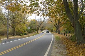
- The road is generally considered to be Cape Cod's most historic and scenic highway.
- The only portions of the Provincetown section under state (or federal) maintenance are the Commercial Street section (including Bradford between Commercial and Allerton) and the Provincelands Road section (which runs through National Park land). The remainder of the Bradford Street section has always been locally maintained, and though that section carries the occasional mile marker from the last postings in 1979, it has always only sparsely been signed as Route 6A.
- There was once another section of Route 6A running through downtown Truro along Truro Center Road, although it was never signed or mile-markered. When Truro Center Road and North Truro's Shore Road were turned back to local maintenance in 1979, the Route 6A designation was officially removed from the downtown Truro section, though locals still referred to it as "Route 6A" until it was officially named "Truro Center Road" when Truro obtained E-911 service.
- The Shore Road section went at least 40 years without a resurfacing. This was evident by the presence of white paint remnants for the lines in the middle of the road that were visible when then-current paint jobs faded. Truro finally resurfaced the road in 2000.
References
- ^ MassHighway, Location Survey Sheets for Mile Marker Program
External links
Road transportation infrastructure of Cape Cod U.S. Routes  State Routes
State Roads Bridges See also: Cape Cod Canal Tunnel · Southside ConnectorCategories:- Numbered routes in Massachusetts
- U.S. Route 6


Wikimedia Foundation. 2010.