- Eastham, Massachusetts
Infobox Settlement
official_name = Eastham, Massachusetts
nickname =
motto =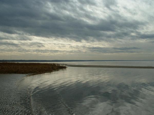
imagesize =
image_caption = First Encounter Beach along Cape Cod Bay in Eastham.
image_
mapsize = 250px
map_caption = Location in Barnstable County in Massachusetts
mapsize1 =
map_caption1 =
subdivision_type = Country
subdivision_name =United States
subdivision_type1 = State
subdivision_name1 =Massachusetts
subdivision_type2 = County
subdivision_name2 = Barnstable
established_title = Settled
established_date = 1644
established_title2 = Incorporated
established_date2 = 1651
established_title3 =
established_date3 =
government_type =Open town meeting
leader_title =
leader_name =
leader_title1 =
leader_name1 =
area_magnitude =
area_total_km2 = 70.6
area_total_sq_mi = 27.3
area_land_km2 = 36.2
area_land_sq_mi = 14.0
area_water_km2 = 34.3
area_water_sq_mi = 13.3
population_as_of = 2000
settlement_type = Town
population_total = 5453
population_density_km2 = 150.5
population_density_sq_mi = 389.8
elevation_m = 15
elevation_ft = 48
timezone = Eastern
utc_offset = -5
timezone_DST = Eastern
utc_offset_DST = -4
latd = 41 |latm = 49 |lats = 48 |latNS = N
longd = 69 |longm = 58 |longs = 28 |longEW = W
website = [http://www.eastham-ma.gov/ www.eastham-ma.gov]
postal_code_type = ZIP code
postal_code = 02642
area_code = 508 / 774
blank_name = FIPS code
blank_info = 25-19295
blank1_name = GNIS feature ID
blank1_info = 0619414
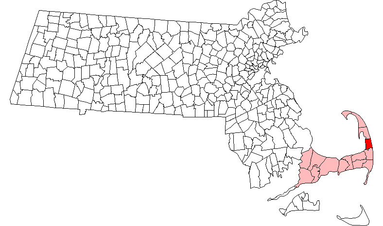
footnotes =Eastham is a town in Barnstable County,
Massachusetts ,United States , Barnstable County being coextensive withCape Cod . The population was 5,453 at the 2000 census.For geographic and demographic information about the village of North Eastham, please see
North Eastham, Massachusetts .History
Originally settled by the
Nauset tribe, Eastham was the site where in 1621 a hunting expedition comprised from the crew of the sailing vessel "Mayflower ", which had stopped in Provincetown harbor on Cape Cod Bay after a rough crossing of the Atlantic Ocean, which led to the first encounter of thePilgrims and the local Nauset Indians at First Encounter Beach. The area would not be settled by Europeans, however, until 1644. The original lands included the towns of Truro, Wellfleet, Eastham, Orleans and a small portion of Chatham. Eastham town was officially incorporated in 1651. Birthplace of Freeman Hatch, who in 1853 set the world record (which still stands) for a single-hull wooden sailing vessel from San Francisco around Cape Horn to Boston aboard the clipper ship "Northern Light". Fishing and especially farming were early industries in the town, and writers and artists also came to the town. In fact, it was in Eastham thatHenry Beston wrote "The Outermost House ." The town is discussed at some length in Henry David Thoreau's "Cape Cod" as the somewhat rugged site of one of New England's largest summer "camp-meeting" evangelistic gatherings in the mid-19th century. The gatherings were at times attended by at least "one hundred and fifty ministers, (!) and five thousand hearers" at a site called Millennium Grove, in the northwest part of town. (The area is now a residential neighborhood, the only reminder being Millennium Lane.)Today, Eastham is mostly known as the "Gate" to the
Cape Cod National Seashore , which was founded in 1961 by PresidentJohn F. Kennedy to protect Cape Cod's coast from erosion and overpopulation. The town is the site of many beaches, both on the Atlantic and bay sides, as well as theNauset Light , which was moved to the town in 1923 from its old location in Chatham, and the Three Sisters Lighthouses, which have since been moved away from their now-eroded perches on the coast to a field just west of Nauset Light. ["Cape Cod, Martha's Vineyard and Nantucket Street Atlas." South Easton, MA: Arrow Books Inc., 2004, p. 43.]Geography
According to the
United States Census Bureau , the town has a total area of 27.2square mile s (70.6km² ), of which, 14.0 square miles (36.2 km²) of it is land and 13.3 square miles (34.3 km²) of it (48.66%) is water. It is bordered byCape Cod Bay and theAtlantic Ocean on its western and eastern sides, respectively. Eastham is also bordered by the towns of Wellfleet and Orleans on its northern and southern sides, respectively. Eastham is located on the "forearm" of Cape Cod, and is twenty-three miles south of Provincetown and east-northeast of Barnstable, thirty-eight miles east of theSagamore Bridge , and ninety-two miles (by land) southeast of Boston.Approximately one-third of the town is located within the
Cape Cod National Seashore . There are several freshwater ponds near the center of town, the largest being called Great Pond, which has two public beaches and does not allow water-skiing. Along the Atlantic coast, portions of the CCNS include several islands, divided by channels which lead from Nauset Bay and Salt Pond Bay to the ocean. The town also shares Town Cove with neighboring Orleans. Also, several creeks and the Herring River run inland from the bay side.Transportation
U.S. Route 6 passes from south to north through the town. The Cape Cod Rail Trail, as well as several other bicycle routes, pass through the town. There is no rail or air service in town; the nearest regional air service is at the Chatham Regional Airport, though better and more regularly scheduled air service between the Cape and Boston can be found in Provincetown and Hyannis through [http://www.capeair.com Cape Air] , and the nearest national and international air service can be found atLogan International Airport in Boston. Eastham is also serviced by an inexpensive regional bus service, [http://www.theflex.org The Flex] .Demographics
As of the
census GR|2 of 2000, there were 5,453 people, 2,396 households, and 1,634 families residing in the town. Thepopulation density was 389.8 people per square mile (150.5/km²). There were 5,535 housing units at an average density of 395.6/sq mi (152.8/km²). The racial makeup of the town was 96.31% White, 1.49% African American, 0.15% Native American, 0.31% Asian, 0.04% Pacific Islander, 0.29% from other races, and 1.41% from two or more races. Hispanic or Latino of any race were 0.83% of the population.There were 2,396 households out of which 21.9% had children under the age of 18 living with them, 55.0% were married couples living together, 9.9% had a female householder with no husband present, and 31.8% were non-families. 25.5% of all households were made up of individuals and 12.4% had someone living alone who was 65 years of age or older. The average household size was 2.24 and the average family size was 2.66.
In the town the population was spread out with 17.7% under the age of 18, 5.0% from 18 to 24, 23.7% from 25 to 44, 27.6% from 45 to 64, and 26.0% who were 65 years of age or older. The median age was 48 years. For every 100 females there were 93.6 males. For every 100 females age 18 and over, there were 89.0 males.
The median income for a household in the town was $42,618, and the median income for a family was $51,269. Males had a median income of $36,642 versus $32,109 for females. The
per capita income for the town was $24,642. About 4.5% of families and 7.0% of the population were below thepoverty line , including 6.5% of those under age 18 and 7.3% of those age 65 or over.Government
Eastham is represented in the
Massachusetts House of Representatives as a part of the Fourth Barnstable district, which includes (with the exception of Brewster) all the towns east and north of Harwich on the Cape. The town is represented in theMassachusetts Senate as a part of the Cape and Islands District, which includes all of Cape Cod, Martha's Vineyard and Nantucket except the towns of Bourne, Falmouth, Sandwich and a portion of Barnstable. [ [http://www.mass.gov/legis/citytown.htm Index of Legislative Representation by City and Town, from Mass.gov] ] The town is patrolled by the Second (Yarmouth) Barracks of Troop D of theMassachusetts State Police . [ [http://www.mass.gov/?pageID=eopsterminal&L=5&L0=Home&L1=Law+Enforcement+%26+Criminal+Justice&L2=Law+Enforcement&L3=State+Police+Troops&L4=Troop+D&sid=Eeops&b=terminalcontent&f=msp_divisions_field_services_troops_troop_d_msp_field_troop_d_station_d2&csid=Eeops Station D-2, SP Yarmouth] ]On the national level, Eastham is a part of
Massachusetts's 10th congressional district , and is currently represented byBill Delahunt . The state's senior (Class I) member of theUnited States Senate , re-elected in 2006, isTed Kennedy . The junior (Class II) Senator, up for re-election in 2008, isJohn Kerry .Eastham is governed by the
open town meeting form of government, and is led by a town administrator and aboard of selectmen . The town hall, police and fire department headquarters are all located along Route 6 across from Windmill Park. The Eastham Public Library is located just west of the park, along Samoset Road (which leads from Route 6 to First Encounter Beach). There are separate post offices for Eastham and the village of North Eastham, both of which are located along Route 6 (the former being just across from the town hall, south of the park).Education
Eastham, along with Brewster, Orleans and Wellfleet, make up the Nauset Regional School District. Each town is responsible for operating its own elementary schools, with the middle and high school students attending regional schools. Eastham Elementary School serves students from kindergarten through fifth grade, and is located near the CCNS Visitor Center and the Schoolhouse Museum. Middle school students attend the Nauset Regional Middle School in Orleans, and the
Nauset Regional High School is located in North Eastham, on the edge of the Cape Cod National Seashore. The school's teams are known as the Warriors, and their colors are black and gold. It should be noted that, due to controversy, the Nauset Indian logo for the school has been revoked, but there are rumors that it will be reinstated. High school students also have the option of attending Cape Cod Regional Technical High School in Harwich free of charge. There are no private schools in Eastham; the nearest are in Brewster.Landmarks
Eastham is home to a number of sites that are listed on the
National Register of Historic Places . The Eastham Center Historic District, located near Town Hall, is the site ofEastham Windmill , the oldestwindmill on Cape Cod. Another registered historic place,Nauset Light , is located on the grounds of theCape Cod National Seashore .ee also
*
List of Registered Historic Places in Barnstable County, Massachusetts References
External links
* [http://www.eastham-ma.gov/Home/ Town of Eastham official website]
* [http://www.easthamchamber.com/ Eastham Chamber of Commerce tourist information]
* [http://www.provincetownbanner.com/articles/ Provincetown Banner]
*
Wikimedia Foundation. 2010.