Bourne Bridge

Bourne Bridge

Infobox Bridge
bridge_name=Bourne Bridge


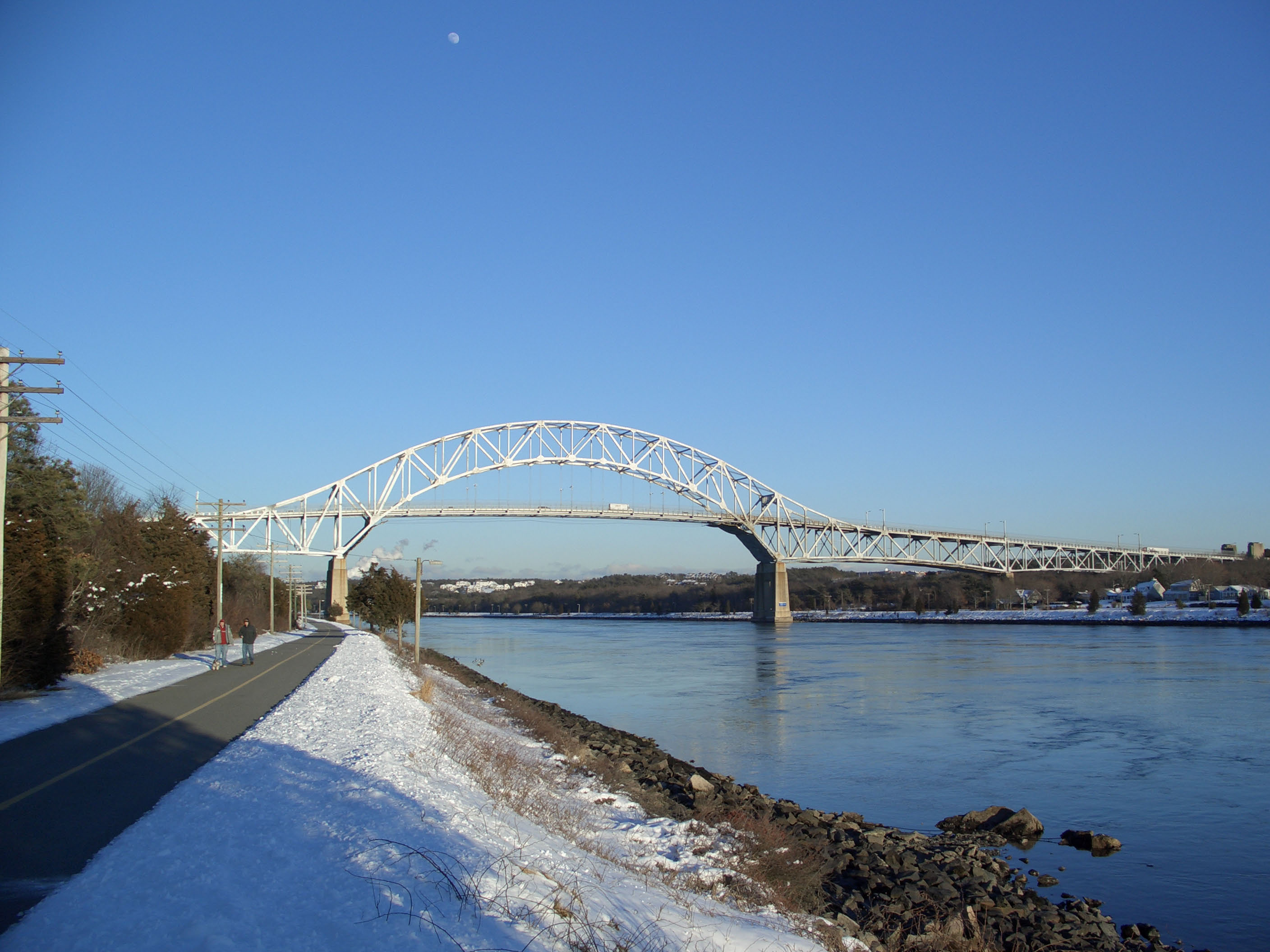
caption=Cape Cod Canal - Bourne Bridge
official_name=
carries=
crosses=Cape Cod Canal
locale=Bourne, Massachusetts
maint=United States Army Corps of Engineers
id=
design=Arch bridge with suspended deck
mainspan=616 ft (188 m)
length=2,384 ft (727 m)
width=45 ft (14 m)
height=
load=
clearance=
below=135 ft (41 m)
traffic=
begin=1933
complete=
open=June 22, 1935
closed=
toll=
map_cue=
map_

map_text=
map_width=
coordinates= coord|41|44|52.36|N|70|35|23.12|W|display=inline,title
lat=
long=

The Bourne Bridge in Bourne, Massachusetts carries Route 28 across the Cape Cod Canal, connecting Cape Cod with the rest of Massachusetts, USA.

Most traffic approaching from the west follows Massachusetts Route 25, which ends at the interchange with US 6/Route 28 just north of the bridge, and provides freeway connections from Interstate 495 and Interstate 195.

History

The bridge, along with its sibling, the Sagamore Bridge, was constructed beginning in 1933 by the Public Works Administration for the United States Army Corps of Engineers, which operates both the bridges and the canal. Both bridges carry four lanes of traffic over a 616-foot (188 m) main span, with a 135-foot (41 m) ship clearance, and opened on June 22, 1935. Due to the topography of the land, however, the approaches to the main span are considerably longer than those of the Sagamore.

The bridge replaces an earlier, 1911 drawbridge; the current structure was built to accommodate the widening of the canal. Like the old Sagamore Bridge, the original drawbridge's approaches are still accessible.

The bridge commences at a major rotary, this one on the east (Cape Cod) end.

External links

*

Crossings navbox
structure = Crossings
place = Cape Cod Canal
bridge = Bourne Bridge
bridge signs =
upstream = Sagamore Bridge
upstream signs =
downstream = Cape Cod Canal Railroad Bridge
downstream signs =


Wikimedia Foundation. 2010.

Игры ⚽ Нужно решить контрольную?

Look at other dictionaries:

  • Bourne High School — is a public high school located in Bourne, Massachusetts. The school serves roughly 900 students in grades 9 12 that reside in the town of Bourne. Bourne High School is located about 1 mile west of the famous Bourne Bridge and Cape Cod engraved… …   Wikipedia

  • Bourne, Massachusetts — Infobox Settlement official name = Bourne, Massachusetts nickname = motto = imagesize = image caption = Bourne Town Hall image mapsize = 250px map caption = Location in Barnstable County in Massachusetts mapsize1 = map caption1 = subdivision type …   Wikipedia

  • Bourne Abbey — is the name of the parish church in Bourne, Lincolnshire, England. The building remains in parochial use, despite the sixteenth century dissolution, as the nave was used by the parish, probably from the time of the foundation of the Abbey in 1138 …   Wikipedia

  • Bourne End Railway Bridge — Infobox Bridge bridge name= Bourne End Railway Bridge caption=Bourne End Railway Bridge showing cantilevered footbridge official name= carries=Marlow Branch Line Thames Path crosses=River Thames locale= Bourne End, Buckinghamshire maint= id=… …   Wikipedia

  • Bourne End, Buckinghamshire — Coordinates: 51°34′54″N 0°42′48″W / 51.581737°N 0.713382°W / 51.581737; 0.713382 …   Wikipedia

  • Bourne End railway station — Infobox UK station name = Bourne End code = BNE manager = First Great Western. locale = Bourne End borough = Wycombe usage0405 = 0.254 usage0506 = 0.240 usage0607 = 0.238 platforms = 2 start = 1873Bourne End railway station serves Bourne End in… …   Wikipedia

  • Bourne–Morton Canal — The Bourne–Morton Canal is an archaeological feature to the north east of Bourne in Lincolnshire, England.[1] In old maps and documents it is known as the Old Ea. It was a 6.5 km artificial waterway linking the dry ground at Bourne to the… …   Wikipedia

  • Bridge, Kent — infobox UK place country = England official name= Bridge static static image caption=Bridge church latitude= 51.2450 longitude= 1.1274 map type= population = 1467 [ [http://www.neighbourhood.statistics.gov.uk/dissemination/LeadTableView.do?a=3… …   Wikipedia

  • Sandwich Road (Bourne) — Sandwich Road is a two lane state highway [PDFlink| [http://www.eot.state.ma.us/downloads/planning/dataResources/Jurisdiction District5.pdf Jurisdiction of Roads in District 5] |7.62 MB] in Bourne, Massachusetts, United States, running from… …   Wikipedia

  • Sagamore Bridge — Infobox Bridge bridge name=Sagamore Bridge caption=Cape Cod Canal Sagamore Bridge official name= carries= crosses=Cape Cod Canal locale=Sagamore, Massachusetts maint=United States Army Corps of Engineers id= design=arch bridge with suspended deck …   Wikipedia

Share the article and excerpts

Direct link
Do a right-click on the link above
and select “Copy Link”