- Braintree Split
Infobox road
marker_
highway_name=Braintree Split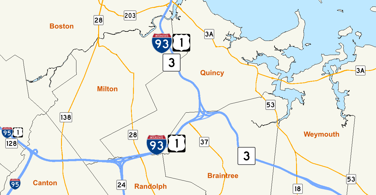
state=MA
maint=MassHighway The Braintree Split is the intersection ofInterstate 93 and MA Route 3 located along the city line separating Braintree andQuincy, Massachusetts . The Braintree Split was also the southern end of Route 128 until 1997, when Route 128 was truncated to the I-95/I-93 intersection in Canton. [ [http://www.bostonroads.com/roads/MA-128/ Yankee Division Highway Historic Overview] bostonroads.com.] Weekday traffic volume through the intersection averages 250,000 to 275,000 vehicles per day. [http://www.bostonmpo.org/bostonmpo/4_resources/1_reports/1_studies/2_highway/braintree_split/braintree_split_p1.pdf "I-93/Southeast Expressway/Route 3 (Braintree Split): "Operational Assessment and Potential Improvements"] Boston Region Metropolitan Planning Organization, March 2006, p. 3. ] The term "Braintree Split" is used as a focal point in all local radio and television traffic reports. [Weinreb, Michael, [http://www.bostonmagazine.com/articles/traffic_report/ Traffic Report] ,Boston Magazine , May 2002.]The Braintree Split, technically a "Directional T" type of interchange, is the main road gateway to the South Shore region of
Massachusetts , making it a critical point in Boston's highway system. The Southeast Expressway is the single limited access highway traveling south out of Boston, carrying traffic from the city destined for communities in populous Norfolk (650K residents)GR|2 and Plymouth (472K residents)GR|2 counties. Drivers other than those headed for parts of Milton and Quincy which straddle the Expressway traverse the split to connect with Route 3 and Route 24 traveling to those southern localities. Similarly, Boston traffic bound for cities and towns inSoutheastern Massachusetts including western Norfolk and Bristol County (535K residents)GR|2 and inRhode Island negotiate the Braintree Split prior to continuing along Route 24 orInterstate 95 . Finally, Route 3 serves as the primary freeway route toCape Cod from Boston's Inner Core. Travelers headed north from these destinations into Boston via I-93 likewise encounter the interchange in Braintree.Factors local to the Braintree Split contribute to chronic congestion at the interchange. The split is bordered on the south by
South Shore Plaza , a major regional shopping mall. It is adjacent to the I-93 intersection with Route 37/Granite Street in Braintree which feeds retail, manufacturing and office complexes along Wood Road and Forbes Road, which run parallel to the north and south lanes of I-93 west of the split. Short weaves, lane drops and line-of-sight problems all contribute to congestion in the interchange and the highways it serves. In addition to these issues, the split also serves the Quincy Adams subway station and Burgin Parkway, a major route into downtown Quincy, through ramps exiting the directional ramps for each roadway.References
Wikimedia Foundation. 2010.