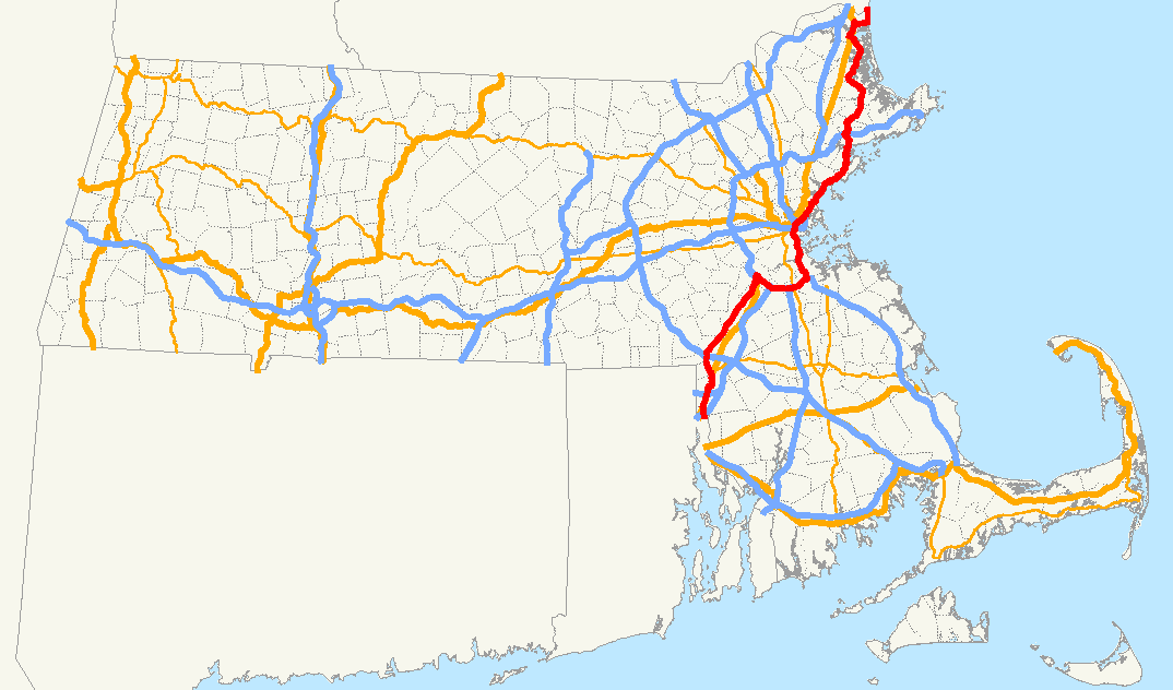
- Massachusetts Route 1A
-
Route 1A

Route information Length: 94.26 mi[1] (151.70 km) Existed: by 1927 – present Major junctions South end:  U.S. Route 1A in Pawtucket, RI
 I-95 in Attleboro
 U.S. Route 1 in Attleboro
U.S. Route 1 in North Attleborough
Boston-Providence Tpk. in Dedham

 I-93/US 1/Rt. 3 in Boston
 Mass Pike I-90/Mass Pike in Boston
 Route 128 in Beverly
U.S. Route 1 in NewburyportNorth end:  Route 1A in Seabrook, NH
Highway system Massachusetts State Highway Routes
← US 1Route 2  →
→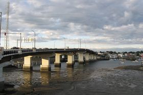

Veterans Memorial Bridge entering Beverly Route 1A is a south–north state highway in Massachusetts. It is an alternate route to U.S. 1 with three signed sections and two unsigned sections where the highway is concurrent with its parent. Due to the reconfiguration of tunnel interchanges brought on by the completion of the Big Dig, Route 1A is discontinuous in the downtown Boston area.[2]
Contents
Route description
Attleboro
A short segment of Route 1A, 1.8 miles (2.9 km) in length, in Attleboro runs from U.S. Route 1A at the Rhode Island border through a junction with Interstate 95, before heading north and merging with Route 1. The entire length of this segment is known as Newport Avenue.
County Location Mile Roads intersected Notes Bristol Attleboro 0.00 U.S. Route 1ASouthern terminus of Route 1A, crosses into Rhode Island (as US-1A). 0.4 Interstate 95I-95 Exits 2A-B. 1.7  Route 123
To U.S. Route 1 South, via Route 123 West.1.8 
U.S. Route 1 NorthNorthern terminus of Route 1A (Attleboro segment).
No access to US-1 South from Route 1A; use Route 123.North Attleborough to Dedham
This segment of Route 1A extends roughly north from North Attleborough to Dedham, passing through the towns of Plainville, Wrentham, Norfolk, Walpole, Norwood and Westwood on the way. Prior to its realignment along I-95 and I-93, Route 1 continued north along the Providence Highway towards Boston at the junction of Route 1A and that road.
County Location Mile Roads intersected Notes Bristol North Attleborough 7.1 U.S. Route 1Southern terminus of Route 1A (N. Attleborough-Dedham segment). Norfolk Plainville 8.0  Route 106
Western terminus of Route 106. Wrentham 10.6  Interstate 495
I-495 Exit 15. 11.4  Route 121
Eastern terminus of Route 121. 12.8  Route 140
Norfolk 15.1  Route 115
Walpole 19.7  Route 27
To US-1/I-95, via Route 27 South.Dedham 27.1 Providence Highway (formerly U.S. Route 1) Northern terminus of Route 1A (N. Attleborough-Dedham segment).
To I-95/Route 128/US-1.Boston to Salisbury
This segment of Route 1A extends from Boston, Massachusetts to Salisbury, Massachusetts.
The highway starts from US 1 (which is on the Central Artery with I-93 and Route 3) at the former Government Center/Logan Airport interchange. It passes through the Callahan Tunnel (outbound/northbound, no toll) and Sumner Tunnel (inbound/southbound, toll), becoming the East Boston Expressway past Logan Airport. The East Boston Expressway was the first freeway built in the city. Immediately beyond Logan Airport, Interstate 90 ends at Route 1A.
The road continues as a divided highway through Revere. It is a limited access highway through Revere, passing Suffolk Downs and the Wonderland Greyhound Park (which is across the street from the outer terminus of the MBTA's Blue Line, before running through the isolated Point of Pines neighborhood) and exiting Revere over the General Edwards Bridge into Lynn. For the first mile and a half in Lynn, it is concurrent with the Lynnway, and is a high-traffic retail area. After the Lynnway portion, the route becomes concurrent with Route 129 for a mile, before crossing into Swampscott as Paradise Road. At Vinnin Square, it passes into Salem as Loring Avenue, passing by Salem State University. The route turns left onto Lafayette Street and is concurrent with Route 114. At the intersection with Derby Street, notable for the large fire station, the route turns right. At the next stop sign, the route turns left onto Hawthorne Boulevard passing Salem Common and the Salem Witch Museum before turning left onto Winter Street. At the end of Winter Street, the route turns right onto Bridge Street crossing the Veterans Memorial Bridge into Beverly. It follows two of the main streets of downtown Beverly, before heading north, passing through Wenham and Hamilton (through this section the road is occasionally signed as a US Route) before becoming the main road through the town of Ipswich, crossing the historic Choate Bridge over the Ipswich River. While in Ipswich, much of the route runs concurrently with Route 133 until just over the town line into Rowley. It passes through the main village of Rowley, as well as the central villages of Newbury. In Newburyport, Massachusetts, it merges with Route 1, signed with its parent highway over the Merrimack River and into the town center of Salisbury. It then heads east from the Salisbury town center before turning north and ending in Salisbury Beach at the New Hampshire border. New Hampshire Route 1A continues north from this point.
County Location Mile Roads intersected Notes Suffolk Boston 47.7 Interstate 93
U.S. Route 1
Route 3Southern terminus of Route 1A (Boston-Salisbury segment).
I-93 (Central Artery) Exit 24 (partial interchange).
No access to Route 1A from I-93 North; no access to I-93 South from
Route 1A. For these connections, useMass Pike/I-90.49.4 Mass Pike/I-90Eastern terminus of I-90.
No access from I-90 to Route 1A South.
To Logan International Airport.East Boston 49.7  Route 145
Southern terminus of Route 145; interchange. Revere 50.0 Route 145Partial interchange; northbound exit, southbound entrance only. 52.1  Route 16
 Route 60
Eastern terminus of Route 16.
Eastern terminus of Route 60.Essex Lynn 58.3  Route 129
Salem 61.8 

 Route 114 East
Southern terminus of Route 1A/114 concurrency. 62.8 
Route 114 WestNorthern terminus of Route 1A/114 concurrency. 63.4  Route 107
Northern terminus of Route 107. Beverly 64.6  Route 22
 Route 127
Southern terminus of Route 22.
Southern terminus of Route 127.65.5  Route 62
66.9  Route 97
Southern terminus of Route 97. 67.1 Route 128Route 128 Exits 20A-B. Ipswich 75.1
 Route 133 East
Southern terminus of Route 1A/133 concurrency. Rowley 79.1
Route 133 WestNorthern terminus of Route 1A/133 concurrency.
To U.S. Route 1.Newburyport 87.7
 Route 113
Eastern terminus of Route 113. 88.1 
U.S. Route 1 SouthSouthern terminus of US-1/Route 1A concurrency. Salisbury 90.1
U.S. Route 1 North
 Route 110
Northern terminus of US-1/Route 1A concurrency.
Eastern terminus of Route 110.94.26 NH Route 1ANorthern terminus of Route 1A; crosses into New Hampshire (as NH-1A). Major interchanges
Attleboro segment
- Interstate 95 at Exit 2A-B (Attleboro)
North Attleborough to Dedham segment
- Interstate 495 at Exit 15 (Wrentham)
(Note: Although it crosses Interstate 95 again just before its terminus, it does not have any direct exit on the route; signage for Exit 15 indicates it can be reached from there.)
Boston to Salisbury segment
- Interstate 93/U.S. 1/Route 3 (Boston)
- Interstate 90/Massachusetts Turnpike (Boston)
- Route 16 (Revere)
- Route 128 (Beverly)
- U.S. 1 (Newburyport and Salisbury)
References
- ^ Executive Office of Transportation, Office of Transportation Planning - 2007 Road Inventory
- ^ Executive Office of Transportation - Office of Transportation Planning Roads - June 2008 The older tunnels to and from East Boston have interchanges with I-93 and surface roads north of the point at which unsigned Route 1A "exits" Route 1 in downtown Boston. Unsigned Route 1A along the Fitzgerald Expressway does not directly connect to those tunnels; a direct connection requires using I-90 and the newer Ted Williams Tunnel, which is not concurrent with Route 1A at any point.
External links
- Massachusetts Executive Office of Transportation - Boston's First Expressway
- East Boston Expressway - Historic Overview
Categories:- Numbered routes in Massachusetts
- U.S. Route 1


Wikimedia Foundation. 2010.