- Ipswich, Massachusetts
Infobox Settlement
official_name = Ipswich, Massachusetts
nickname = Birthplace of American Independence
motto =
image_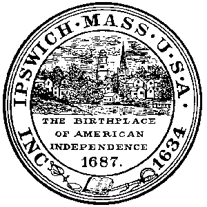
imagesize = 250px
image_caption = Ipswich riverfront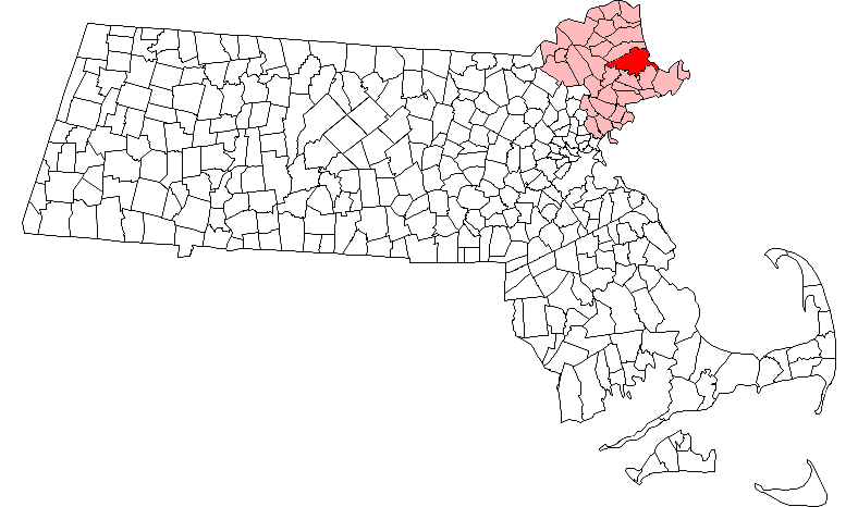
mapsize = 250px
map_caption = Location in Essex County in Massachusetts
mapsize1 =
map_caption1 =
subdivision_type = Country
subdivision_name =United States
subdivision_type1 = State
subdivision_name1 =Massachusetts
subdivision_type2 = County
subdivision_name2 = Essex
established_title = Settled
established_date = 1633
established_title2 = Incorporated
established_date2 = 1634
established_title3 =
established_date3 =
government_type =Open town meeting
leader_title =
leader_name =
leader_title1 =
leader_name1 =
area_magnitude =
area_total_km2 = 109.1
area_total_sq_mi = 42.1
area_land_km2 = 84.4
area_land_sq_mi = 32.6
area_water_km2 = 24.8
area_water_sq_mi = 9.6
population_as_of = 2000
settlement_type = Town
population_total = 12987
population_density_km2 = 153.9
population_density_sq_mi = 398.6
elevation_m = 15
elevation_ft = 50
timezone = Eastern
utc_offset = -5
timezone_DST = Eastern
utc_offset_DST = -4
latd = 42 |latm = 40 |lats = 45 |latNS = N
longd = 70 |longm = 50 |longs = 30 |longEW = W
website = http://www.town.ipswich.ma.us/
postal_code_type = ZIP code
postal_code = 01938
area_code = 351 / 978
blank_name = FIPS code
blank_info = 25-32310
blank1_name = GNIS feature ID
blank1_info = 0619448
footnotes =Ipswich is a coastal town in Essex County,
Massachusetts ,United States . The population was 12,987 at the 2000 census. Home to Willowdale State Forest and Sandy Point State Reservation, Ipswich includes the southern part of Plum Island and Plum Island State Park. A residential community with a vibranttourism industry, the town is famous for its clams, celebrated annually at the Ipswich Chowderfest and also forCrane Beach , a beautiful barrier beach near the Crane estate.History
Native Americans called the area Agawam, meaning "lowland, marsh or meadow (with water)." Here they hunted and caught fish, especially
shellfish , leaving behind mounds of shells. Captain John Smith wrote about the region in 1614, referring to it as "an excellent habitation, being a good and safe harbour." A plague of about 1617, perhapssmallpox brought from abroad, devastated the once populous Indian tribe. In 1633,John Winthrop , governor of theMassachusetts Bay Colony , sent his son, also named John, and 12 men aboard ashallop to settle the town. It was incorporated in 1634 as Ipswich, afterIpswich in the county ofSuffolk ,England , the source of prominent early settlers.Nathaniel Ward , an assistant pastor in town from 1634 to 1636, wrote the first code of laws for Massachusetts and later published the religious/political work, "The Simple Cobbler of Aggawam in America" in England.Pioneers would become farmers, fishermen, shipbuilders or traders. The tidal
Ipswich River providedwater power for mills, andsalt marsh es supplied hay forlivestock . Acottage industry inlace-making developed. But in 1687, Ipswich residents, led by the Reverend John Wise, protested a tax imposed by the governor, SirEdmund Andros . As Englishmen, they argued, taxation without representation was unacceptable. Citizens were jailed, but then Andros was recalled toEngland in 1689, and the new Britishsovereigns , William and Mary, issued colonists another charter. The rebellion is the reason the town calls itself the "Birthplace of American Independence."Great
clipper ships of the 19th century, however, bypassed Ipswich in favor of deep-waterseaport s at Salem and Newburyport. The town remained primarily a fishing and farming community, its residents living in older homes they could not afford to replace -- leaving Ipswich with a considerable inventory of earlyarchitecture . In 1822, astocking manufacturing machine which had been smuggled out of England arrived at Ipswich, violating a British ban on exporting technology, and the community would develop as amill town . In 1828 theIpswich Female Seminary was founded. In 1868, Amos A. Lawrence established the Ipswich Hosiery Mills beside the river. It would expand into the largest stocking mill in the country by the turn of the century.In 1910, Richard T. Crane, Jr. of Chicago, the magnate owner of Crane Plumbing, bought Castle Hill, a
drumlin on Ipswich Bay. He hiredOlmsted Brothers , successors toFrederick Law Olmsted , to landscape his convert|3500|acre|km2|sing=on estate, and engaged the Boston architectural firm of Shepley, Rutan & Coolidge to design an ItalianRenaissance Revival stylevilla on the summit. A grandeallée , convert|160|ft|m wide and lined withstatuary , would run the half mile from house to sea. But his wife, Florence, loathed the building. Crane promised that if she still didn't like it in 10 years, he would replace it. True enough, in 1928 a new 59-roommansion designed by Chicago architectDavid Adler in the English Stuart style stood in its place, called the Great House. At Mrs. Crane's death in 1949, the entire property was bequeathed to The Trustees of Reservations, which uses it as a venue for concerts and weddings. [Salny, Stephen M. (2001). "The Country Houses of David Adler", pp. 63-71. New York: W.W. Norton & Company. ISBN 039373045X.]The house was designated a
National Historic Landmark in 1998. It was a filming location for the 1987 movie "The Witches of Eastwick", based on the novel written byJohn Updike . For many years a resident of Ipswich, Updike used the community as a model for his fictional town of Tarbox. Other movies with scenes filmed in Ipswich include "The Thomas Crown Affair" (1968), "Flowers in the Attic" (1987), "Glory" (1989), "Mermaids" (1990), "The Crucible" (1996), and "National Treasure " (2003).Constructed in 1829, to provide power to the Willowdale Mills, the historic Willowdale Dam now provides the scenic backdrop at the access point to the river for the canoeing enthusiast.
Flood ing in May 2006 caused extensive damage to three bridges in town. The Choate Bridge (built in 1764), a stonearch bridge , was closed as a result of structural damage. County Street Bridge and Mill Bridge were also closed for repairs. The Mill Bridge remains closed 2 years after the storm as various historical, town and state agencies bicker over funding and the proper way to repair the bridge, inconveniencing residents and increasing traffic loads on other less suitable roads. Following the bridge closings, a fire occurred in an historical block of shops adjacent to the Choate Bridge.
John Whipple House (1642) in c. 1910
Geography
According to the
United States Census Bureau , the town has a total area of 42.1 square miles (109.1km² ), of which, 32.6 square miles (84.4 km²) of it is land and 9.6 square miles (24.8 km²) of it (22.69%) is water. Ipswich is drained by the Ipswich River and adjacent toCape Ann .Demographics
"This article describes the town of Ipswich as a whole. Additional demographic detail is available which describes only the more densely-populated central settlement or village within the town, although that detail is included in the aggregate values reported here. See:
Ipswich (CDP), Massachusetts ."As of the
census of 2000, there were 12,987 people, 5,290 households, and 3,459 families residing in the town. Thepopulation density was 398.6 people per square mile (153.9/km²). There were 5,601 housing units at an average density of 66.4 persons/km² (171.9 persons/sq mi). The racial makeup of the town was 97.60% White, 0.39%African American , 0.08% Native American, 0.80%Asia n, 0.01% Pacific Islander, 0.33% from other races, and 0.79% from two or more races. 1.04% of the population wereHispanic orLatino of any race.There were 5,290 households out of which 30.1% had children under the age of 18 living with them, 54.0% were married couples living together, 8.4% have a woman whose husband does not live with her, and 34.6% were non-families. 28.3% of all households were made up of individuals and 11.7% had someone living alone who was 65 years of age or older. The average household size was 2.42 and the average family size was 3.00.
In the town the population was spread out with 23.0% under the age of 18, 5.1% from 18 to 24, 28.3% from 25 to 44, 28.1% from 45 to 64, and 15.6% who were 65 years of age or older. The median age was 42 years. For every 100 females there were 89.8 males. For every 100 females age 18 and over, there were 86.2 males.
The median income for a household in the town was $57,284, and the median income for a family was $74,931. Males had a median income of $51,408 versus $38,476 for females. The
per capita income for the town was $32,516. 7.1% of the population and 4.1% of families were below the poverty line. Out of the total people living in poverty, 7.8% are under the age of 18 and 13.0% are 65 or older.Education
Ipswich High School [http://www.ipswichschools.org/ihsweb/hshome/index.htm] has been considered one of the best public high schools in the Boston area. Middle School and High School are connected in the same building and share library, cafeteria and athletic resources (tennis courts, a soccer field, a football field, and a running track).
In 2006, the high school was named a "Blue Ribbon" school. Blue Ribbon is an award for national excellence in education under the
No Child Left Behind legislation. The school also received a Vanguard award for similar academic prowess. IHS offers a great deal of college-prep, honors, and AP-level classes. IHS also has one of the best graduation rates in Massachusetts.Paul F. Doyon Elementary School and Winthrop Elementary school are the town's two elementary schools. The two schools are devoted to the use of the
Everyday Math program, despite national criticism of its methodology.The school district has had significant budget cuts over the past several years, and the current budget draft proposes the cut of the elementary music program, two elementary teachers, and the entire high school technology program (drafting, engineering/CAD, and robotics), as well as no provision for the purchase of new technology or upkeep of existing technology (computers, software, multimedia). Despite both academic achievement awards and highly qualified teaching staff under NCLB criteria, the district is currently considered to be one of the lowest paid teaching staff relative to the surrounding districts in the Cape Ann region. The budget problems in the district led to discussion of a funding override; however, overrides failed in past town meetings because of the increase in property taxes they would entail. The override issue came at a time when people were losing their homes to foreclosure, fuel and food prices were soaring, and the economy was slowing. Given the current economic landscape, persuading voters to endorse a tax hike was sure to be a contentious effort. However, the override passed.
The high school school mascot is the Tiger and the school colors are Orange, Black & White. Ipswich competes in the Cape Ann League. Football won the Division 3A Super Bowl Championship in 2006. It was the schools first title since 1992, and the 5th in school history. (1974, 1977, 1991, 1992, 2006) Ipswich's biggest rivals are Newburyport and Hamilton-Wenham Regional of Hamilton, MA.
Points of interest
* Castle Hill (1928)
* John Heard House (c. 1800)
*John Whipple House (1642/1677)
*Crane Beach Transportation
MBTA Commuter Rail provides service from Boston'sNorth Station with the Ipswich station on its Newburyport branch of theNewburyport/Rockport Line .Ipswich Essex Explorer provides weekend service during the summer toCrane Beach , downtown Essex and other nearby attractions.Notable residents
*
Anne Bradstreet , poet
*Simon Bradstreet , governor
*Chevy Chase , comedian, actor
*Nathan Dane , lawyer
*Arthur Wesley Dow , artist
*Thomas Dudley , governor
*Dennis Eckersley , Hall-of-Fame Pitcher
*Ed Emberley , artist of children's drawing books
*Nancy Kerrigan , former Olympic skater
*John Norton , Puritan divine, author, minister at Ipswich 1636
*Caleb Stone , artist
*John Updike , author
*Nathaniel Ward , clergyman & juristTrivia
*The town of Innsmouth, a setting for several stories of
H. P. Lovecraft 'sCthulhu Mythos , is a close neighbor in the stories - many inhabitants of Innsmouth do their shopping in Ipswich.
*Is the setting for the 2006 film "The Covenant".
*The Feoffees of the Grammar School of Ipswich are the only feoffees in the United States, probably.References
* [http://www.town.ipswich.ma.us/history.htm Town of Ipswich History]
External links
* [http://www.town.ipswich.ma.us/ Official Website]
* [http://www.ipswicharts.com/ Official Ipswich Arts & Culture Website, Ipswich, Massachusetts]
* [http://www.thetrustees.org/pages/249_appleton_farms.cfm Appleton Farms]
* [http://www.thetrustees.org/pages/308_greenwood_farm.cfm Greenwood Farm]
* [http://www.thetrustees.org/pages/311_hamlin_reservation.cfm Hamlin Reservation]
* [http://www.ipswichchowderfest.com/ Ipswich Chowderfest]
* [http://www.town.ipswich.ma.us/library/ Ipswich Public Library]
* [http://www.ipswichmuseum.org Ipswich Historical Society & Museum]
* [http://www.stateparks.com/plum_island.html Plum Island State Park]
* [http://www.mass.gov/dcr/parks/northeast/sndp.htm Sandy Point State Reservation]
* [http://www.mass.gov/dcr/parks/northeast/wild.htm Willowdale State Forest]
* [http://www.oldeipswich.com/attract.html Olde Ipswich Attractions]
Wikimedia Foundation. 2010.