- Natick, Massachusetts
-
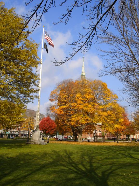
Natick, Massachusetts — Town — Natick Common, Halloween 2004
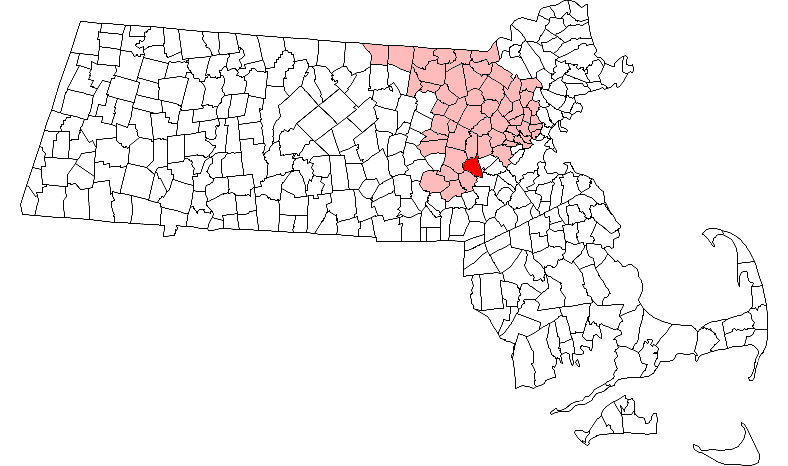
SealNickname(s): Home of Champions Location in Middlesex County in Massachusetts
Coordinates: 42°17′00″N 71°21′00″W / 42.2833333°N 71.35°WCoordinates: 42°17′00″N 71°21′00″W / 42.2833333°N 71.35°W Country United States State Massachusetts County Middlesex Settled 1651 Incorporated 1781 Government – Type Representative town meeting Area – Total 16.1 sq mi (41.6 km2) – Land 15.1 sq mi (39.1 km2) – Water 1.0 sq mi (2.5 km2) Elevation 180 ft (55 m) Population (2010) – Total 33,006 – Density 2,117.5/sq mi (817.8/km2) Time zone Eastern (UTC-5) – Summer (DST) Eastern (UTC-4) ZIP code 01760 Area code(s) 508 / 774 FIPS code 25-43895 GNIS feature ID 0619407 Website www.natickma.gov Natick (
 /ˈneɪtɨk/) is a town in Middlesex County, Massachusetts, United States. Natick is located near the center of the MetroWest region of Massachusetts, with a population of 33,006 at the 2010 census. Only 15 miles (24 km) west from Boston, Natick is considered part of the Greater Boston area. The center of population of Massachusetts in 2000 was located in Natick.[1]
Contents
Name
The name Natick comes from the language of the Massachusett Native American tribe and means place of hills. The original settlement, in the community of South Natick, is a hilly area. Located in the community of West Natick is Captain Tom's Hill, which was the site of a small Indian encampment during King Philips War.
History
Natick was first settled in 1651 by John Eliot, a Puritan missionary born in Widford, Hertfordshire, England who received a commission and funds from England's Long Parliament to settle the Massachusett Indians on both sides of the Charles River, on land deeded from the settlement at Dedham. They were called Praying Indians – Eliot was best known for attempting to preserve the culture (minus the religion) of the Native Americans by putting them in thirteen planned towns where they could continue by their own rule, with Natick as the political and spiritual center. Eliot and Praying Indian translators printed America's first written Bible in the Algonquian language.[2][3]
The colonial government placed such settlements in a ring of villages around Boston as a defensive strategy. Natick was the first and best documented of such settlements. The land was granted by the General Court, part of the Dedham Grant.
A school was set up, a government established, and the Indians were encouraged to convert to Christianity. In November 1675, during King Philip's War, the Natick Indians were sent to Deer Island. Many died of disease and cold, and the Indians who survived found their homes destroyed. The Indian village did not fully recover, and the land held in common by the Indian community was slowly sold off to white settlers to cover debts, and, by 1785, most of the Natick Indians had drifted away.
In 1775, both English and Praying Indian citizens of Natick participated in the Battles of Lexington and Bunker Hill, as well as serving in the Continental Army. The names of the Praying Indian soldiers from Natick are memorialized on a stone marker, along with all of Natick's Revolutionary War veterans, on a stone marker on Pond St near downtown Natick.[4]
The town was officially incorporated in 1781. Henry Wilson, a U.S. senator born in 1812 who became eighteenth Vice President of the United States (1873–1875), and who lived most of his life in Natick as a shoemaker and schoolteacher and was known as the "Natick Cobbler",[5] is buried there. He is the namesake of one of Natick's middle schools.
Though Natick was primarily a farming town, the invention of the sewing machine in 1858 led to the growth of several shoe factories. The business flourished and peaked by 1880, when Natick, with twenty-three operating factories, was third in the nation in the quantity of shoes produced. The shoes made in Natick were primarily heavy work shoes with only one or two companies adding lighter dress shoes to their line. Natick was famous for its brogan, a heavy ankle-high boot worn by soldiers in the American Civil War. The wound core for a more resilient ball was developed by John W. Walcott and combined with the figure-eight stitching devised by Col. William A. Cutler. It was manufactured by the firm of H. Harwood & Sons in their factory built in 1858 – the first plant in the world for the manufacture of baseballs. In 1988 the H. Harwood & Sons factory was converted into baseball factory condominiums[6]
In 1874, a great fire in downtown Natick demolished 18 business blocks, two shoe factories, the Town Hall, Natick's only fire engine house and the Congregational Church, as well as many private homes. Though no lives were lost, the loss of property was greater in proportion to the town's wealth than the Great Chicago Fire of 1871. In 1875, Natick's new Central Fire Station was completed on Summer Street and opened with grand ceremony on the same city block where the great fire was first discovered. The Central Fire Station is now the home of a private non-profit community performing arts center called The Center for Arts in Natick (TCAN).
Miles 8 through 12 of the Boston Marathon run through Natick on Patriots Day every year along Route 135/Central St., and thousands of residents and visitors line the road to watch.
Geography
According to the United States Census Bureau, the town has a total area of 16.0 square miles (41 km2), of which, 15.1 square miles (39 km2) of it is land and 1.0 square mile (2.6 km2) of it is water. The total area is 7.04% water, including bodies of water Lake Cochituate and Dug Pond.
Communities and neighborhoods
Natick Center
 Natick Center
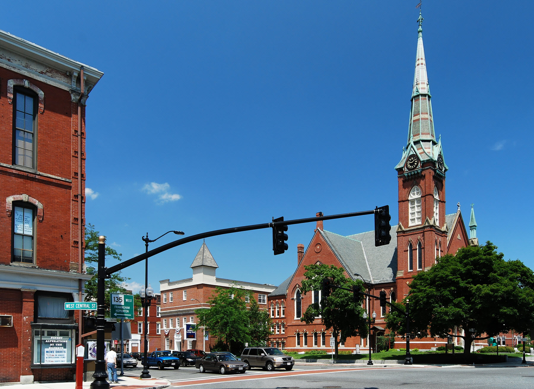
Natick Center, which is also known as Downtown Natick, is located at the intersection of Central Street and Main Street and serves as the civic and cultural hub of the town.
Many public services and public land use are located downtown. Municipal buildings like the Natick Town Hall, Natick Fire Department, Natick Police Department and Morse Institute Library are located here along East Central Street. Also located directly downtown is the Natick Town Common where many town events and community activities are held. An MBTA Commuter Rail station links Natick with Boston and Worcester. In the 1990s new downtown construction of a town hall, fire/police station, and enlargement to the library gave the downtown a fresh new look. New municipal buildings exist alongside several historic buildings and churches, the restored Central Fire House, several banks, restaurants and small businesses.
South Natick
South Natick, known for its scenic nature, is where the Native American settlers first arrived and began the town on the shores of the Charles River. Housing developers like Martin Cerel lived in South Natick, and thus refrained from building major tract neighborhoods in this part of town. A common mistake is the belief that South Natick is a separate town or village, but that is not the case. South Natick is simply a section of the town, governed by the Town of Natick. This misconception may be due to street signage such as a sign located in Wellesley along Route 16 that has the destination listed as "So. Natick." Due to this and many other reasons, it is common to see mail addressed to South Natick, Massachusetts rather than just Natick, Massachusetts.
North Natick
North Natick is located at the intersections of North Main Street and Worcester Road. It is a primarily residential area but there is a retail strip mall at the intersection of N. Main and Worcester known as 27/9 which includes business and stores such as http://www.building19.com/locations/NATICK.htm Staples, Super Stop & Shop, Building 19, Panera Bread, Five Guys, The UPS Store, and Hair Cuts Ltd. The Wilson Middle School is located behind the Stop & Shop.
East Natick
East Natick is a community of Natick that is located along Oak Street and at the intersection of Oak and Worcester Road. Notable landmarks include Jennings Pond, the Industrial Park on Oak St North, and the Lilja School. A sports and tennis club is located in East Natick off Oak St. in a part of the Industrial Park. The stretch of Route 9 in East Natick as one heads into Wellesley, contains a multitude of ever-changing retail businesses.
West Natick
West Natick is a large section of Natick that borders the town of Framingham. The Natick Mall, as well as the strip mall called Sherwood Plaza with its office Industrial Park behind, are considered to be the commercial hub of West Natick. In addition to its retail development, post World War II housing developments like Westfield, Pelham, and Sherwood as well as the National Guard depot and a golf course on Speen St brought many people to this part of town.
There are many businesses in West Natick along West Central Street as well as another MBTA Commuter Rail station in addition to the one downtown. The area in West Natick, along Route 135 is the most densely populated section of town, with its thousands of condominiums and apartments clustered across the street from the train station.
Neighborhoods
Natick is a small town, and thus, the various sections of tract development homes are considered neighborhoods. These were houses built by several contractors in the late 1940s until the late 1950s. Listed here, are a few of these sections.
Sherwood
One of the earliest post World War II developments in West Natick, the homes are colonial in style, with street names reminiscent of the Robin Hood legend. The homes were built in 1948 and the neighborhood remains popular due to the fact that there's no through traffic, and most of the houses have been enlarged with additions.
Walnut Hill
Walnut Hill is a neighborhood located north of downtown. It is known for the private boarding school, Walnut Hill School as well as many Victorian era houses lining Walnut and Bacon Streets.
Wethersfield
The Wethersfield area of Natick is a residential neighborhood North of Route 9. It is a typical 1950s development of Campanelli ranch houses, and remains popular with first time home-buyers, due to the relatively inexpensive nature of slab style houses. This area includes Drury lane and all connecting roads within the boundaries of route 9, Pine st. and Route 27.
Oak Street
South of Rte 9, this section began as a summer vacation area, with tiny cottages surrounding Jennings Pond. Over the years, some houses were enlarged, but the area remains quaint, and quiet with no thru-traffic. On the westerly side of South Oak, is a neighborhood of Cape style houses with streets named after World War II Generals. North of Route 9, other developments of small Cape-style homes were built in the early and mid 1950s and these houses remain popular with first-time home buyers due to the affordability of the houses. There are two Industrial Parks along north Oak St which contain office buildings on one side of the road, and larger warehouses on the eastern side.
Little South
Just south of the Natick Common, Cottage Street begins what is commonly called Little South, named so because of its proximity to South Natick. Little South nomenclature extends to the east portions of Everett Street, down to Eliot St. Homes along Cottage St. were primarily built in the early 1950s and are mostly modest, and well maintained. The best known landmarks in Little South are a WWII monument dedicated to the fallen soldiers from Natick, and The Tobin School, a private daycare and elementary school that has two large, attractive buildings off of Cottage St. Everett St. has larger farm homes situated on generous lots. Eliot St., which runs parallel to the Charles River, boasts some of the oldest and nicest homes in Natick. Just before South Natick begins, there is a beautiful Virgin Mary statue on a large rock on the south side of the Charles River, enveloped by graceful pine trees.
Demographics
Historical populations Year Pop. ±% 1850 2,744 — 1860 5,515 +101.0% 1870 6,404 +16.1% 1880 8,479 +32.4% 1890 9,118 +7.5% 1900 9,488 +4.1% 1910 9,866 +4.0% 1920 10,907 +10.6% 1930 13,589 +24.6% 1940 13,851 +1.9% 1950 19,838 +43.2% 1960 28,831 +45.3% 1970 31,057 +7.7% 1980 29,461 −5.1% 1990 30,510 +3.6% 2000 32,170 +5.4% 2001* 32,238 +0.2% 2002* 32,160 −0.2% 2003* 32,111 −0.2% 2004* 31,973 −0.4% 2005* 31,838 −0.4% 2006* 31,705 −0.4% 2007* 31,806 +0.3% 2008* 31,962 +0.5% 2009* 32,335 +1.2% 2010 33,006 +2.1% * = population estimate.
Source: United States Census records and Population Estimates Program data.[7][8][9][10][11][12][13][14][15][16]As of the census[17] of 2000, there were 32,170 people, 13,080 households, and 8,528 families residing in the town. The population density was 2,132.9 people per square mile (823.7/km2). There were 13,368 housing units at an average density of 886.3 per square mile (342.3/km2). The racial makeup of the town was 90.02% White, 1.63% African American, 0.11% Native American, 3.86% Asian, 0.05% Pacific Islander, 0.77% from other races, and 1.56% from two or more races. Hispanic or Latino of any race were 3.97% of the population.
There were 13,080 households out of which 30.3% had children under the age of 18 living with them, 54.5% were married couples living together, 8.2% had a female householder with no husband present, and 34.8% were non-families. 28.3% of all households were made up of individuals and 9.8% had someone living alone who was 65 years of age or older. The average household size was 2.42 and the average family size was 3.02.
In the town the population was spread out with 23.0% under the age of 18, 5.1% from 18 to 24, 34.3% from 25 to 44, 23.3% from 45 to 64, and 14.3% who were 65 years of age or older. The median age was 38 years. For every 100 females there were 89.7 males. For every 100 females age 18 and over, there were 85.3 males.
According to a 2007 estimate,[18] the median income for a household in the town was $81,855, and the median income for a family was $105,056. Males had a median income of $51,964 versus $41,060 for females. The per capita income for the town was $36,358. About 1.7% of families and 2.8% of the population were below the poverty line, including 2.4% of those under age 18 and 5.3% of those age 65 or over.
Natick is surrounded, on three sides, by five of the ten most affluent towns in Massachusetts [19] with Wayland to the north, Weston to the northeast, Wellesley to the east, Dover to the southeast, and Sherborn to the southwest. In addition to these five very-wealthy communities, Framingham lies immediately to the west. Similar to Natick but larger in size and population, Framingham is largely middle class and has areas of semi-rural affluence, although Framingham has the issue of urban blight in its downtown area which Natick has managed to avoid.
Government
Town
Natick has representative town meeting form of government with a Board of Selectmen and a Town Administrator.[20] The current members of the Board and the dates their terms end are:
- Charles M. Hughes, Chairman, 2013;
- Carol A. Gloff, Vice Chair, 2014;
- Paul R. Joseph, Clerk, 2013;
- Nicholas S. Mabardy, 2014; and
- Joshua Ostroff, 2012.
County
Mismanagement of Middlesex County's public hospital in the mid 1990s left the county on the brink of insolvency, and in 1997 the Massachusetts legislature stepped in by assuming all assets and obligations of the county. The government of Middlesex County was officially abolished on July 11, 1997. The sheriff and some other regional officials with specific duties are still elected locally to perform duties within the county region, but there is no county council or commissioner. However, communities are now granted the right to form their own regional compacts for sharing services.
These are the remaining elected officers for Middlesex County:
- Clerk of Courts: Michael A. Sullivan
- County Treasurer: Position Eliminated
- District Attorney: Gerard T. Leone, Jr.
- Register of Deeds: Richard P. Howe, Jr. (North at Lowell), Eugene C. Brune (South at Cambridge)
- Register of Probate: Tara E. DeCristofaro
- County Sheriff: James DiPaola
Education
Public schools
The Natick Public School District operates the following schools:[21]
- High school:
- Natick High School; The High School building on the shore of Dug Pond, was opened in 1954. In order to avoid loss of accreditation, the residents voted approval of a tax override, aka. a "debt exclusion" for construction of a new High School building and related improvements. The new building design is based on a model approved by the state of Massachusetts. This was necessary in order to maximize state reimbursement for design and construction. It's expected to cost over $80 million. The new high school will be built adjacent to the current high school and is scheduled to be complete by the beginning of the 2012/2013 school year.
- Middle schools:
-
- Kennedy Middle School;
- Wilson Middle School.
- Elementary schools:
-
- Brown Elementary School;
- Lilja Elementary School;
- Memorial Elementary School;
- Bennett-Hemenway (Ben-Hem) Elementary School;
- Johnson Elementary School;
Private schools
- Brandon School and Residential Treatment Center[22]
- The Eliot Montessori School[23]
- Walnut Hill School[24]
- The Tobin School[25]
Notable residents
In alphabetical order:
- Horatio Alger, Jr., minister, author of children's books with a rags to riches theme, settled in Natick in 1860 and built his family home in South Natick
- Thomas S. Allen, American composer
- James Bamford, author, journalist who writes about the world of United States intelligence agencies
- John Carlson, NHL player for the Washington Capitals
- William Finn, Tony-winning composer
- Keene Fitzpatrick, legendary track coach at Yale, Michigan and Princeton, 1890–1932
- Darren Flutie, CFL and NFL veteran who attended Natick High School before going to Boston College; 2nd all time in receptions in the CFL. CFL Hall of Famer
- Doug Flutie, NFL and CFL veteran who attended high school in Natick, before going to Boston College; retired from the New England Patriots after the 2005–06 season; resides in Natick, 50th Heisman Trophy winner; also played for many other NFL teams, including the Buffalo Bills
- Alison Fraser, Broadway performer and two-time Tony Award nominee grew up in Natick; graduated from Natick High School (1973)
- Alfred S. Hartwell (1836–1912), commanded the 55th Massachusetts Infantry Regiment, sister regiment of the 54th Massachusetts Infantry, during the Civil War. He led Union troops into Charleston, South Carolina when it fell and worked for the Freedman's Bureau. Moved to the Kingdom of Hawaii in 1868 and was appointed Chief Justice of the Hawaiian Supreme Court.
- Walt Hriniak, briefly a Major League Baseball player and, more notably, a prominent batting coach.
- Harold Kushner, rabbi and author of many books, especially known for When Bad Things Happen to Good People'.
- Harvey Leonard, chief meteorologist for WCVB-TV
- Meg Mallon, professional golfer on the LPGA Tour and twice winner of the U.S. Women's Open
- William Nutt, moved to Natick in 1856, went to Kansas to oppose pro-slave forces there in 1858 and was an organizer of the Natick Shoe Strike in 1860. Served with the 55th Massachusetts Infantry during the Civil War and rose to the rank of Colonel.
- Michael Owen former principal dancer, American Ballet Theatre
- Rob Patterson, former guitarist for Otep, touring guitarist for Korn, currently the guitarist for Filter (band) and engaged to Carmen Electra
- Rene Rancourt, professional singer, sings the national anthem at all home Boston Bruins hockey games.
- Jonathan Richman, proto-punk rock icon and founder of The Modern Lovers
- Harriet Beecher Stowe (June 14, 1811 – July 1, 1896) was an American author and abolitionist, whose novel Uncle Tom's Cabin (1852) attacked the cruelty of slavery and received world-wide acclaim. Her novel "Old Town Folks" was written while she was living in Natick and tells the story of her husband's family.
- Alexander Wheelock Thayer, United States consul at Trieste in 1859 and author of a biography of Ludwig van Beethoven published in 1866
- Waban, 17th-century tribal chief
- Mark Walker, Grammy award-winning drummer
- Sara Whalen, Olympic soccer silver medalist
- Henry Wilson, the eighteenth Vice President of the United States, lived at 33 West Central Street and worked as a shoemaker at his shoe shop at 181 West Central Street.
Points of interest
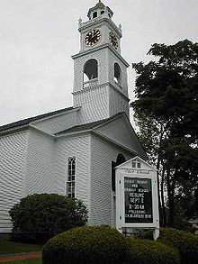 Eliot Church in South Natick, Mass.
- The Bacon Free Library, which opened in 1881, is located at 58 Eliot Street. This building was a gift to the community under the will of Oliver Bacon who died in 1878. It has been operating as a public library ever since. The library overlooks the Charles River in South Natick. The Natick Historical Society resides in the lower portion of the building.
- Temple Israel of Natick, Natick's oldest Synagogue, is located on Hartford street. It is currently the largest Conservative Synagogue in the area, and serves many communities in the Metro West area.
- The Natick Historical Society, located in the lower level of the Bacon Free Library. Archives and exhibits on John Eliot and Praying Indians, natural history collections, life during colonial times, early republic and industrial revolution, memorabilia of famous Natick citizens.
- Eliot Church, originally founded as a meetinghouse in 1651, is the fifth structure on the site. The present church dates from the 1830s. A sign erected in front of the church in 1930, on the 300th anniversary of the founding of the Massachusetts Bay Colony, reads,"INDIAN MEETINGHOUSE – On this site John Eliot helped his Indian converts to build their first meetinghouse in 1651, with a 'prophet's chamber' where he lodged on his fortnightly visits to preach to them in their language. His disciple Daniel Takawambait succeeded to the pastoral office in 1698."
- The U.S. Army Soldier Systems Center (SSC) (Also known as The Natick Army Labs), a complex of military R&D facilities, produces military-use items such as field rations, personal protective field equipment, and specialized uniforms.
- Natick Collection (formerly the Natick Mall, still its commonly-used name), managed by General Growth Properties, Inc. of Chicago, is one of Boston's premier shopping centers and recently completed a major expansion. The newly renovated wing opened 9/7/07.
- BJ's Wholesale Club Corporate Headquarters.
- Cognex Corporation Corporate Headquarters.
- MathWorks Corporate Headquarters.
- Boston Scientific Corporate Headquarters. This site used to be the HQ for mini-computer manufacturer Prime Computer, Inc. Before Prime, Carling ran a Black Label brewery there.
- The Walnut Hill School is one of the nation's leading private secondary schools, offering particular emphasis in the studio and performing arts. Walnut Hill graduates more students to the Juilliard School than any other secondary school in the world.
- The Center for Arts in Natick (TCAN), located in Natick's historic Central Fire Station, is a favored performance venue for musicians in jazz, folk, classical, and rock genres. TCAN also hosts theatrical productions by the TCAN Players and children's classes in theatre and dance. Artists performing at TCAN have included Judy Collins, Don McLean, George Winston, Paula Poundstone, Rockapella, Karla Bonoff, John Sebastian and Adrian Belew.
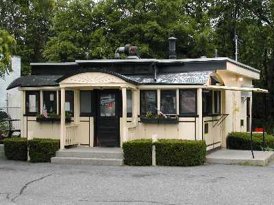
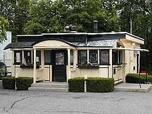 Casey's Diner
- Casey's Diner, constructed in 1922, is one of the oldest operating ten-stool diners in the United States. Casey's Diner is diminutive in size at only 10 feet (3.0 m) by 20-1/2 feet, and was constructed by the Worcester Lunch Car Company in Worcester, Massachusetts. Famous for its steamed hot dogs, Casey's originated as a horse-drawn lunch wagon that was parked on Natick Common.
- The Boden Lane Cemetery is a very small burial site established in 1815. Although the cemetery was established in that year, many of the gravestones are dated even earlier than this date, with some dating back to the Revolutionary War. The cemetery is located on Boden Lane, to the right of Beaver Dam, and directly across the street from the Chabad Center of Natick.
- The Natick Community Organic Farm, located in South Natick on conservation land. It is a certified-organic, fully functioning working open year-round with no admission fee for the public's visits and purchases. The farm welcomes volunteers and runs a bevy of hands-on educational programs for adults and children. The farm has a barn built in 1815, a timber-framed nature center, two greenhouses, two hoophouses, four acres of market gardens, bee hives, woodland walking trails, a composting toilet, and a host of animals including chickens, turkeys, pigs, rabbits, sheep, goats, and cows.
- Henry Wilson Shoe Shop, 181 West Central Street, listed on the National Register of Historic Places
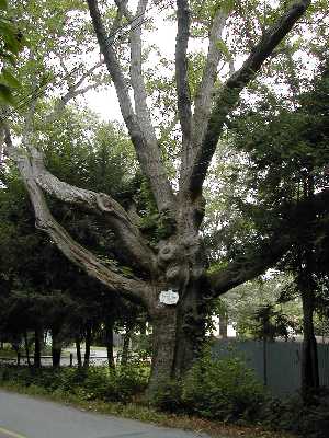
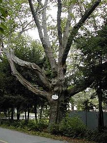 Station Tree in Natick, Mass.
- The station tree is a 500-year-old black oak that the original surveyors used to mark the boundary between Natick and what was then part of Needham. That boundary is now the Natick-Weston town line on Winter Street, near the campus of The Rivers School in Weston, MA. One other notable landmark tree—the Eliot Oak next to the Eliot Church in South Natick—was removed in 1936 after the installation of underground gas lines damaged the root system, ultimately killing it.
- The Chabad Center in Natick is a synagogue and Jewish educational center which is dedicated to strengthening Jewish awareness in the Metrowest area. The Hebrew School for the Arts is a breakthrough in typical Hebrew school education. Located at the Chabad Center, Hebrew School for the Arts teaches traditional Judaism while integrating the modern arts of drama.
- Sassamon Trace Golf Course, built atop the former town landfill, is a branch of the Natick Recreation Department.
- Natick's Recycle Center, adjacent to the town-owned golf course, and the High School athletic fields, serves the town's recycle needs.
In popular culture
Natick appears on the Family Guy episode Da Boom when the family sets out to the town after Peter reveals that there is a Twinkie factory there. (This was at one time true, as a Hostess bakery did once exist on Speen Street, although part of the Factory was in Framingham ) He eventually starts a town on the ruins of the community, naming it New Quahog.
To solvers of the New York Times Sunday crossword puzzle, the term "Natick" has a particular meaning. It refers to any square on the puzzle grid that a solver cannot fill in correctly except by a lucky guess, because the solver does not know the answer to either the ACROSS clue or to the DOWN clue. See Rex Parker Does the New York Times Crossword.
See also
- The Golden Triangle
- Greater Boston
- MetroWest
- Representative town meeting
References
- ^ "Population and Population Centers by State: 2000". http://www.census.gov/geo/www/cenpop/statecenters.txt. Retrieved January 27, 2011.
- ^ John Eliot Bible, 1st Ed. 1663, From Natick Historical Society Collection
- ^ "The Eliot Indian Bible: First Bible Printed in America." Library of Congress Bible Collection. Library of Congress, n.d. Web. 5 Sep 2011.
- ^ Massachusetts Soldiers and Sailors of the Revolutionary War
- ^ James M. McPherson, Battle Cry of Freedom: The Civil War Era (New York: Bantam Books, 1989), p. 139.
- ^ www.baseballfactory.org
- ^ "TOTAL POPULATION (P1), 2010 Census Summary File 1, All County Subdivisions within Massachusetts". United States Census Bureau. http://factfinder2.census.gov/bkmk/table/1.0/en/DEC/10_SF1/P1/0400000US25.06000. Retrieved September 13, 2011.
- ^ "Massachusetts by Place and County Subdivision - GCT-T1. Population Estimates". United States Census Bureau. http://factfinder.census.gov/servlet/GCTTable?_bm=y&-geo_id=04000US25&-_box_head_nbr=GCT-T1&-ds_name=PEP_2009_EST&-_lang=en&-format=ST-9&-_sse=on. Retrieved July 12, 2011.
- ^ "1990 Census of Population, General Population Characteristics: Massachusetts". US Census Bureau. December 1990. Table 76: General Characteristics of Persons, Households, and Families: 1990. 1990 CP-1-23. http://www.census.gov/prod/cen1990/cp1/cp-1-23.pdf. Retrieved July 12, 2011.
- ^ "1980 Census of the Population, Number of Inhabitants: Massachusetts". US Census Bureau. December 1981. Table 4. Populations of County Subdivisions: 1960 to 1980. PC80-1-A23. http://www2.census.gov/prod2/decennial/documents/1980a_maABC-01.pdf. Retrieved July 12, 2011.
- ^ "1950 Census of Population". Bureau of the Census. 1952. Section 6, Pages 21-10 and 21-11, Massachusetts Table 6. Population of Counties by Minor Civil Divisions: 1930 to 1950. http://www2.census.gov/prod2/decennial/documents/23761117v1ch06.pdf. Retrieved July 12, 2011.
- ^ "1920 Census of Population". Bureau of the Census. Number of Inhabitants, by Counties and Minor Civil Divisions. Pages 21-5 through 21-7. Massachusetts Table 2. Population of Counties by Minor Civil Divisions: 1920, 1910, and 1920. http://www2.census.gov/prod2/decennial/documents/41084506no553ch2.pdf. Retrieved July 12, 2011.
- ^ "1890 Census of the Population". Department of the Interior, Census Office. Pages 179 through 182. Massachusetts Table 5. Population of States and Territories by Minor Civil Divisions: 1880 and 1890. http://www2.census.gov/prod2/decennial/documents/41084506no553ch2.pdf. Retrieved July 12, 2011.
- ^ "1870 Census of the Population". Department of the Interior, Census Office. 1872. Pages 217 through 220. Table IX. Population of Minor Civil Divisions, &c. Massachusetts. http://www2.census.gov/prod2/decennial/documents/1870e-05.pdf. Retrieved July 12, 2011.
- ^ "1860 Census". Department of the Interior, Census Office. 1864. Pages 220 through 226. State of Massachusetts Table No. 3. Populations of Cities, Towns, &c.. http://www2.census.gov/prod2/decennial/documents/1860a-08.pdf. Retrieved July 12, 2011.
- ^ "1850 Census". Department of the Interior, Census Office. 1854. Pages 338 through 393. Populations of Cities, Towns, &c.. http://www2.census.gov/prod2/decennial/documents/1850c-11.pdf. Retrieved July 12, 2011.
- ^ "American FactFinder". United States Census Bureau. http://factfinder.census.gov. Retrieved 2008-01-31.
- ^ "Natick town, Middlesex County, Massachusetts – Fact Sheet – American FactFinder". Factfinder.census.gov. http://factfinder.census.gov/servlet/ACSSAFFFacts?_event=Search&geo_id=06000US2502141690&_geoContext=01000US%7C04000US25%7C05000US25021%7C06000US2502141690&_street=&_county=natick&_cityTown=natick&_state=04000US25&_zip=&_lang=en&_sse=on&ActiveGeoDiv=geoSelect&_useEV=&pctxt=fph&pgsl=060&_submenuId=factsheet_1&ds_name=ACS_2007_3YR_SAFF&_ci_nbr=null&qr_name=null®=null%3Anull&_keyword=&_industry=. Retrieved January 27, 2011.
- ^ "List of Massachusetts locations by per capita income – Wikipedia, the free encyclopedia". En.wikipedia.org. http://en.wikipedia.org/wiki/Massachusetts_locations_by_per_capita_income. Retrieved January 27, 2011.
- ^ Town of Natick (December 28, 2010). "Town of Natick – Board Of Selectmen/Town Administrator". Natickma.gov. http://natickma.gov/Public_Documents/NatickMA_Admin/index. Retrieved January 27, 2011.
- ^ Natick Public Schools
- ^ "Brandon School & Residential Treatment Center". Brandonschool.org. http://www.brandonschool.org. Retrieved January 27, 2011.
- ^ "The Eliot Montessori School". Eliotmontessori.org. July 1, 2010. http://www.eliotmontessori.org. Retrieved January 27, 2011.
- ^ "Walnut Hill | Boarding Arts High School for Ballet, Classical Music, Visual Arts, Theater and Writing & Publishing". Walnuthillarts.org. http://www.walnuthillarts.org. Retrieved January 27, 2011.
- ^ "The Tobin School". thetobinschool.org. July 1, 2010. http://www.thetobinschool.org/. Retrieved July 26, 2011.
External links
- Natick official website
- Natick Public Schools
- Morse Institute Library
- Bacon Free Library
- Natick Recreation Department's Farm
- Natick Police Department
- Natick Historical Society
- Natick Historical Commission
- A Brief History of Natick
- Natick's Strategic Planning Initiative
- Natick Soldier Systems Center
- Belkin Family Lookout Farm
Municipalities and communities of Middlesex County, Massachusetts Cities 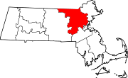
Towns Acton | Arlington | Ashby | Ashland | Ayer | Bedford | Belmont | Billerica | Boxborough | Burlington | Carlisle | Chelmsford | Concord | Dracut | Dunstable | Framingham | Groton | Holliston | Hopkinton | Hudson | Lexington | Lincoln | Littleton | Maynard | Natick | North Reading | Pepperell | Reading | Sherborn | Shirley | Stoneham | Stow | Sudbury | Tewksbury | Townsend | Tyngsborough | Wakefield | Wayland | Westford | Weston | Wilmington | Winchester
CDPs Ayer | Cochituate | Fort Devens | East Pepperell | Groton | Hopkinton | Hudson | Littleton Common | Pepperell | Pinehurst | Shirley | Townsend | West Concord
Other
villagesAuburndale | Chestnut Hill | Gleasondale | Nabnasset | Newton Centre | Newton Highlands | Newton Lower Falls | Newton Upper Falls | Newtonville | Nonantum | North Billerica | North Chelmsford | Waban | West Newton
Categories:- Natick, Massachusetts
- Towns in Middlesex County, Massachusetts
- MetroWest


Wikimedia Foundation. 2010.